By Ross Stein, Temblor
Check your seismic hazard rank
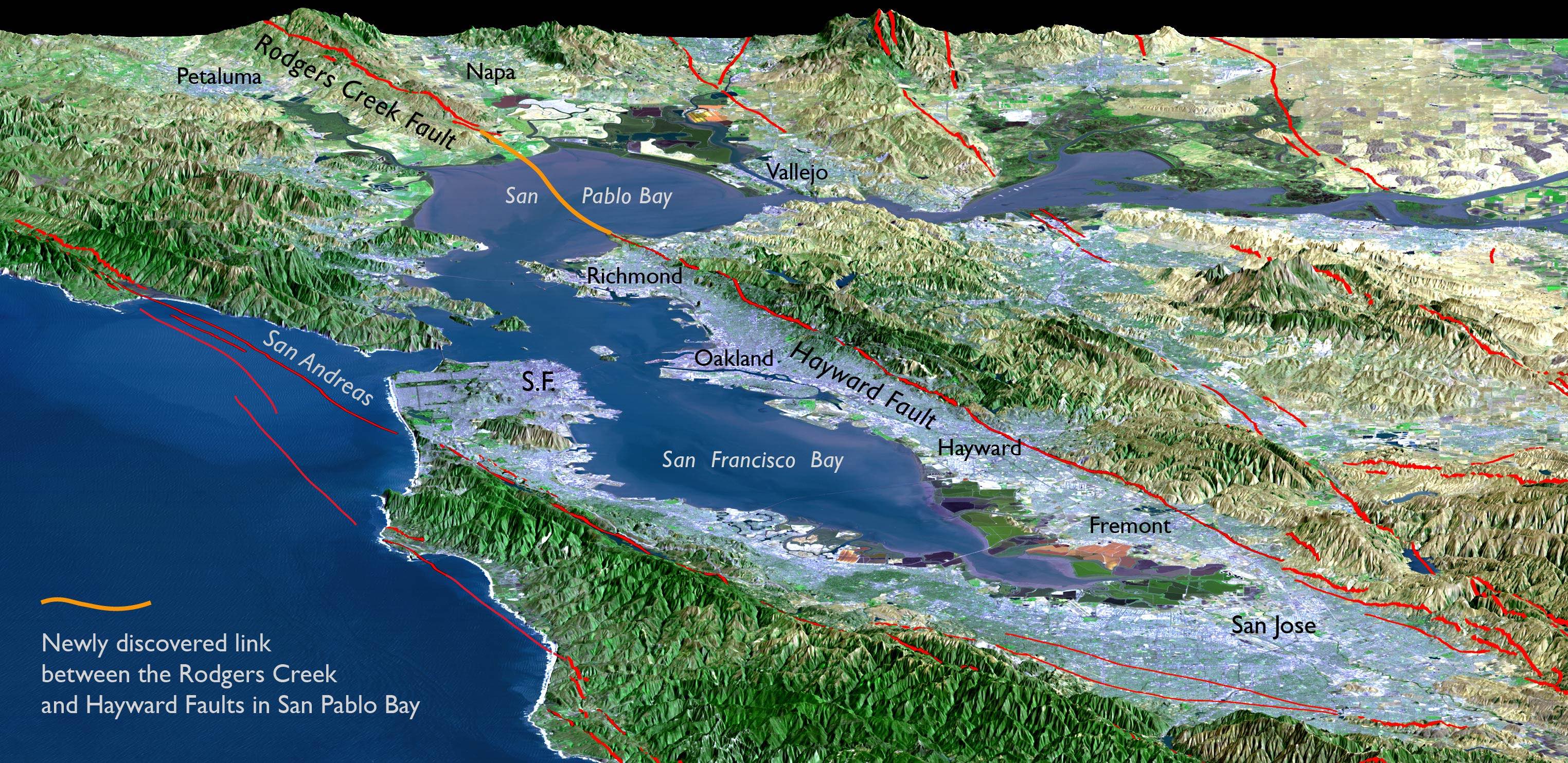
A new finding by Janet Watt and her USGS coauthors appeared last month in Science Advances , heralding a “Missing link between the Hayward and Rodgers Creek faults.” From fine-scale seismic imaging and other geophysical sounding, they argued that the Rodgers Creek and Hayward faults are continuous, connecting through a curved fault section hidden beneath San Pablo Bay. This means that earthquakes as large as M=7.4 are possible on both sides of San Francisco Bay, rather than just on the San Andreas, as we had thought before.
What does this discovery foretell for seismic hazards in the East Bay?
I put this question to USGS colleague and Watt et al. coauthor, Tom Parsons. Tom replied, “I think Janet’s observations show an easier connection than I thought was there. The fault also shows a sharp discontinuity right at the surface, which is very surprising in recently deposited Bay mud. It suggests that either the fault is creeping there, or there has been recent seismic slip.” In fact, according to Watt et al., even the most recent prehistoric earthquakes along the Rodgers Creek fault and Hayward faults, which struck sometime between 1715 and 1776, could have been a single combined event given dating uncertainties. This means that it will be extremely difficult to prove whether such a combined rupture has happened in the past.
I asked if this changes the USGS earthquake probabilities for M=7.4 East Bay shocks. Parsons replied that in the current USGS model (Field et al., 2015), if a rupture is deemed capable of jumping from one fault to the other, then the combined event is just as likely as if there were no jump (or ‘step-over’) at all, and this was the case for the Rodgers Creek and Hayward faults. So, the Watt et al. paper does not change the probability of a combined rupture, which stands at about 4% in the next 30 years, or one chance in 25.


But a M=7.4 could be worse than a lone Rodgers Creek or Hayward Fault rupture
Whenever ruptures speed up or slow down, they shed seismic energy—which we feel as strong shaking. The curve in San Pablo Bay would likely be a ‘speed-bump’ to the rupture front as it unzips at about 5,000 km/hr (3,000 mph) down the fault, causing a spike in shaking, most strongly affecting the surrounding cities of Richmond, Vallejo, Novato, and Napa.
A M=7 shock on either fault would rupture for up to 100 km (60 mi), which would take up to 50 seconds. A combined rupture could double that duration to up to 100 seconds. Compare that to the M=6.9 Loma Pieta shock, which took a mere 20 seconds. The longer the shaking continues, the more buildings, bridges, pipelines, and dams would fatigue. Think of a thin stainless steel strap: Bend it back and forth a few times and it weakens; do this repeatedly and it snaps.
USGS earthquake engineer, Erol Kalkan, commented to me that “Long-duration shaking may weaken structures due to ‘low-cycle fatigue,’ and aftershocks could escalate failures of structures already weakened by the mainshock.” He also pointed out that most seismic design codes, including in the U.S., are based on ground-shaking intensity, but do not explicitly take into account the duration. A long shaking duration may also increase the liquefaction hazard.” This much is clear: the stronger the building, the better it would fare.
Rather than concealing the link, San Pablo Bay is its offspring
You would be forgiven for thinking that the reason it has taken so long to reveal the fault link is that it’s hidden under San Pablo Bay. But it’s actually cheaper and easier to capture high quality seismic reflection images like the one below with a single ship than with a fleet of trucks, and marine sediments preserve the delicate stratification of layers better than on land, particularly urban land.

Instead, repeated fault slip through the curved section has caused the area to subside, creating the trough in the landscape that captures the drainage from the Great Valley that we know as the Delta. So, perhaps if the fault had not thrown us a curve, San Francisco would not have been the gateway to the Gold Rush, sending countless steamships across the ‘missing link,’ in San Pablo Bay, ferrying would-be miners to Sacramento and the Sierran gold fields.

Janet commented to me, “The ability to measure centimeter-scale deformation on the Earth’s surface through satellite radar (InSAR), topographic (LiDAR), and seismic (chirp) measurements has illuminated heretofore unknown fault connectivity. The 2016 M=7.8 Kaikoura earthquake in New Zealand is another case where these measurements could reveal whether the seemingly independent ruptures are also connected.”
If it’s one fault, it should have one name
If the Watt et al. paper stands, and I see no reason why it will not, it’s time to retire the name ‘Rodgers Creek Fault, and rechristen the entire 175 km (120 mi) long feature the ‘Hayward Fault.’ This is something that the USGS and California Geological Survey could do in concert, and it would be a fitting reminder of this fault’s unrivaled ability to damage a major U.S. urban corridor.
Sources
Janet Watt, David Ponce, Tom Parsons, Patrick Hart (2016), Missing link between the Hayward and Rodgers Creek faults, Science Advances, 2: e1601441, DOI: 10.1126/sciadv.1601441.
Edward H. Field, Glenn P. Biasi, Peter Bird, Timothy E. Dawson, Karen R. Felzer, David D. Jackson, Kaj M. Johnson, Thomas H. Jordan, Christopher Madden, Andrew J. Michael, Kevin R. Milner, Morgan T. Page, Tom Parsons, Peter M. Powers, Bruce E. Shaw, Wayne R. Thatcher, Ray J. Weldon II, and Yuehua Zeng (2015), Long-Term Time-Dependent Probabilities for the Third Uniform California Earthquake Rupture Forecast (UCERF3), Bull. Seismol. Soc. Amer., 105, 511–543, doi: 10.1785/0120140093
- Earthquake science illuminates landslide behavior - June 13, 2025
- Destruction and Transformation: Lessons learned from the 2015 Gorkha, Nepal, earthquake - April 25, 2025
- Knock, knock, knocking on your door – the Julian earthquake in southern California issues reminder to be prepared - April 24, 2025