Researchers link subducting plate angle to earthquake events that produce larger than normal tsunamis — helpful information for future tsunami risk awareness.
By: Danielle Woodring, M.S., structural geologist/science writer (@daniellew0123)
Citation: Woodring, D., 2020, Subducting plate angle dictates tsunami threat during large earthquakes, Temblor, http://doi.org/10.32858/temblor.101
In 2011, a magnitude-9.1 Tohoku earthquake and subsequent tsunami struck Japan. The economic damage from the event totaled $211 billion dollars (USD) and caused at least 19,000 casualties. The quake originated along the interface between the subducting Pacific plate and the overriding North American plate. Scientists latter determined that a major normal fault near the Japan Trench also slipped during this event, rupturing all the way to the surface. This rupture enhanced shaking and contributed to the associated tsunami that assaulted the coast of Japan.
Large earthquake ruptures and associated tsunamis are among some of the world’s most devastating natural hazards. In a recently published Nature Geoscience article, scientists describe a link between earthquake rupture mechanism and tsunami size. This work allows scientists to better identify regions at high risk of large tsunamis.
Offshore earthquakes cause large tsunamis
Tsunamis can occur when a fault ruptures beneath a large body of water. Earthquakes can generate tsunamis on faults where rocks on one side of the fault are uplifted relative to the other side. When these rocks suddenly move, the overlying water is displaced, generating a large wave of water that moves outward from the fault. When slip along a fault reaches all the way to the earth’s surface, the uplifted area is concentrated near the fault, causing an even larger tsunami than would have occurred if slip occurred only at depth.
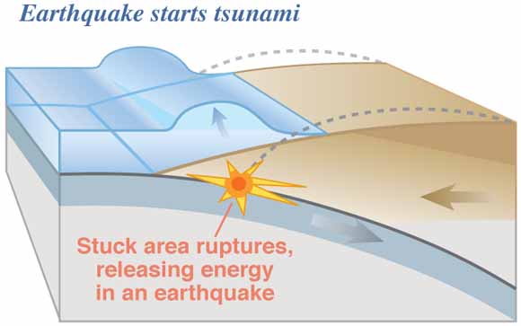
Along subduction zone boundaries between converging tectonic plates, such as offshore Japan, “megathrusts” generate large earthquakes. But in these regions, normal faults — which accommodate stretching, or extension, within the crust — also exist.
Some quakes make big tsunamis, and some don’t
Large tsunami-generating earthquakes are commonly associated with aftershocks along normal faults in the overlying plate, close to subduction zone trenches (e.g. 1960 Peru, 1963 and 1975 Kuril Islands, 1992 Nicaragua earthquakes). This puzzled seismologists, because subduction zones are more commonly associated with convergent or compressional structures, like thrust faults. In this latest study, scientists have found a possible explanation.
Researchers simulated the long-term evolution of a subduction zone and periodic short-term release of stress during earthquakes. They looked at various different scenarios, among which factors such as the angle of the subducting plate varied. They discovered that in scenarios where the angle of the subducting plate decreases over time, the overriding plate bends upward. This results in a widespread region of extensional stress in the overriding plate.

It is unclear why the angle of the subducting plate changes in these settings, according to Bar Oryan, a doctoral student in marine geology and geophysics at Columbia University and lead author of the study. “It may be due to large-scale temperature and density changes,” he says.
Evidence in nature
Oryan and coauthor W. Roger Buck, a geoscientist at Lamont-Doherty Earth Observatory, noticed that the relative location of the largest extensional stresses in the simulation was similar to the location of the major normal fault that ruptured during the 2011 Tohoku earthquake. Additional evidence for a relative ‘shallowing’ of subducting plate angle would be the observation of migration of an active volcanic arc away from the trench over time.
To test the validity of their results, the researchers identified natural subduction zones with volcanic arc migration and long-term uplift of the overriding plate. Geological data collected from the Honshu volcanic arc off the coast of Japan indicates that volcanic activity has moved away from the trench in the recent geological past, which is consistent with a shallowing of the subducting plate angle. This migration is also observed in Nicaragua, and Java. Both of these regions have experienced large tsunami earthquakes and extensional aftershocks. The researchers admit however, that long-term uplift signals on million-year timescales are hard to obtain and that these datasets should be collected to better estimate tsunami hazards.
Tsunami hazards research
“[This type of research] is important to take into account when building these earthquake rupture scenarios”, says Alex Dolcimascolo, a tsunami geologist with the Washington State Geological Survey. In the future, he and colleagues plan to “take into account the rupture of multiple fault sources, not only the main megathrust fault, to better understand and estimate the potential of tsunami hazards in the Pacific Northwest.” Oryan and Buck’s work demonstrates that megathrust earthquake events are complex, and their approach can be applied to subduction zones around the world.

Check your earthquake risk at Temblor.
Further Reading
Oryan, B. and Buck, W.R., 2020, Larger tsunamis from megathrust earthquakes where slap dip is reduced: Nature Geoscience, 8 p., [https://doi.org/10.1038/s41561-020-0553-x].
Kajitani, Y., Chang, S. E. and Tatano, H., 2013, Economic impacts of the 2011 Tohoku-oki earthquake and tsunami: Earthquake Spectra 39, p. 457–478.
Tsuji, T., Kawamura, K., Kanamatsu, T., Kasaya, T., Fujikura, K., Ito, Y., Tsuru, T., and Kinoshita, M., 2013, Extension of continental crust by anelastic deformation during the 2011 Tohoku-oki earthquake: the role of extensional faulting in the generation of a great tsunami: Earth and Planetary Science Letters, v. 364, pp. 44–58.
Witter, R.C., Yinglong, Z., Wang, K., Priest, G.R., Goldfinger, C., Stimely, L.L., English, J.T., and Ferro, P.A., 2011, Simulating Tsunami Inundation at Bandon, Coos County, Oregon, Using Hypothetical Cascadia and Alaska Earthquake Scenarios: Oregon Department of Geology and Mineral Industries Special Paper 43, 57 p.
Eungard, D. W., Forson, Corina, Walsh, T. J., González, F. I., LeVeque, R. J, Adams, L. M., 2018, Tsunami hazard maps of Port Angeles and Port Townsend, Washington—Model results from a ~2,500-year Cascadia subduction zone earthquake scenario: Washington Geological Survey Map Series 2018-03, 6 sheets, scale 1:11,000 and 1:16,000, 11 p. text. [http://www. dnr.wa.gov/publications/ger_ms2018-03_tsunami_hazard_pt_angeles_pt_townsend.zip]
- Venezuela’s doublet leaned toward Caracas - June 30, 2026
- Is Southern California’s Cajon Pass an ‘earthquake gate’ ready to open? - June 29, 2026
- Philippines magnitude 7.8 shock may have loaded the central Cotabato subduction zone - June 11, 2026