By Elisabeth Nadin, Ph.D., Associate Professor, University of Alaska Fairbanks, U.S.
Haluk Eyidoğan, Ph.D., Professor of Seismology, Istanbul Technical University, Turkey
Ali Moradi, Ph.D., Director of Iranian Seismological Center and Assistant Professor, Institute of Geophysics, University of Tehran, Iran
*editor’s note: Haluk Eyidoğan and Ali Moradi provided significant insight into this piece, in addition to their attributed material.
On February 23, 2020, two earthquakes struck the Turkey-Iran border. Scientists from both countries are now working to figure out which faults ruptured during this event.
Citation: Nadin, E., Eyidoğan, H., Moradi, A. (2020), Strong earthquakes on Turkey-Iran border trigger scientific cooperation, Temblor, http://doi.org/10.32858/temblor.074
Faults don’t recognize international boundaries. When large earthquakes occur in border regions, scientists are often left piecing together data from different sources to figure out what happened. This is critical to assessing further seismic hazard in the area.
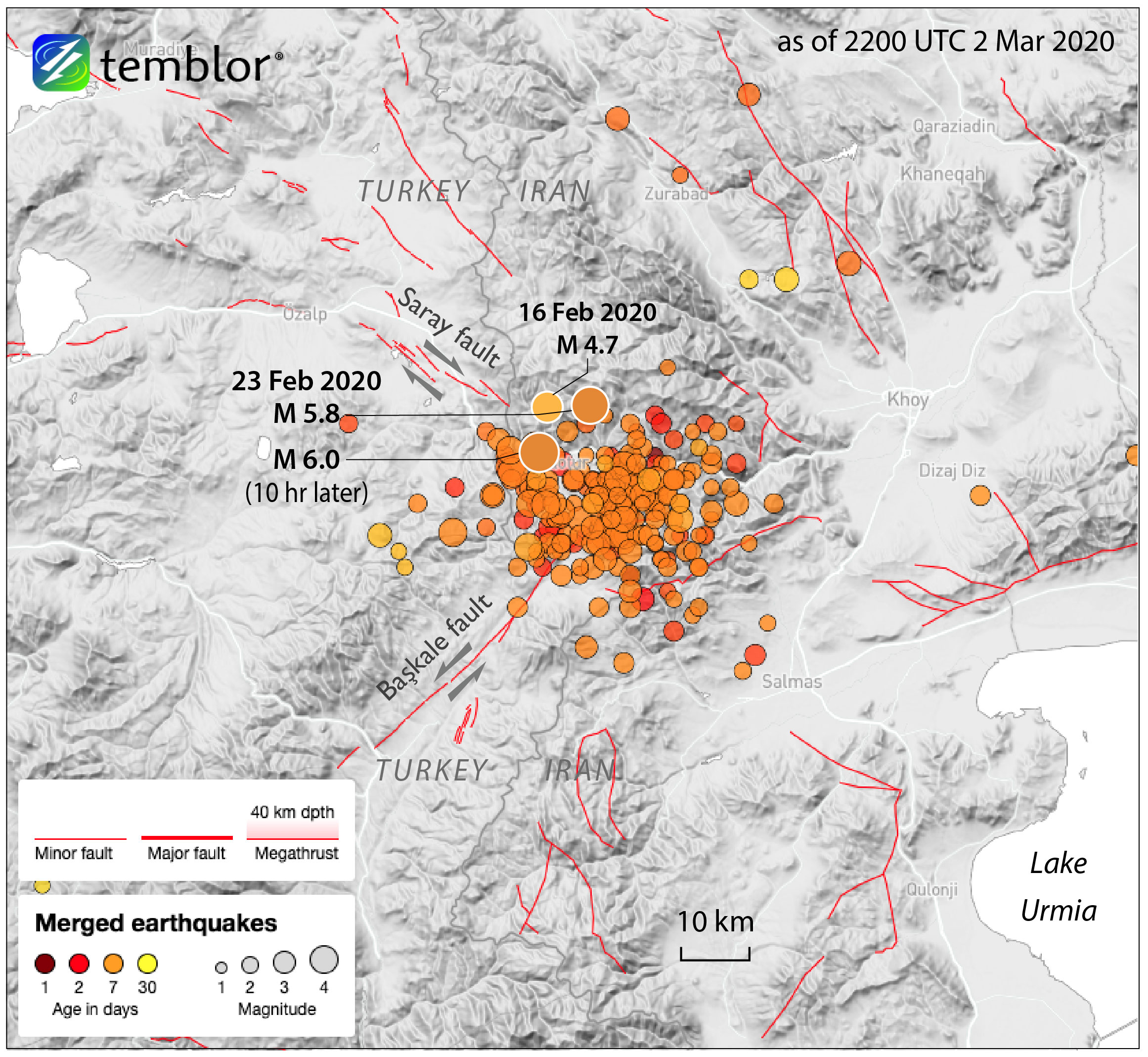
In the early morning hours of February 23, a magnitude 5.8 earthquake rattled the border between Turkey and Iran. That evening, a magnitude 6 quake struck in the same area. Ten days later, geologists in both countries are still trying to figure out exactly which of the numerous faults in this region ruptured.
A cluster of earthquakes
The February 23 events were among several notable quakes in the region in recent days. A cluster of earthquakes occurred in northwestern Iran over the past few weeks, including a magnitude-4.7 on 16 February. The magnitude 5.8 caused 10 fatalities in Turkey, more than 100 injuries between the two countries, and thousands of destroyed or damaged buildings. Ten hours later, the magnitude-6 struck within the same cluster.
Although seismic hazard agencies around the world calculate earthquake magnitude and location within minutes to hours of any large event, it can still be difficult to know exactly which fault ruptured, and what its precise orientation is. This information is important to understanding future earthquake risk in a region because in some cases energy released during one earthquake could increase stress on a neighboring fault, driving it toward failure.
Science across borders
Seismologists Haluk Eyidoğan of Turkey and Ali Moradi of Iran are trying to converge on what faults in the region slipped during this series of earthquakes. They suspect that a pair of conjugate faults—two faults that intersect like an “X” through Earth’s crust —is to blame.
The complex network of faults throughout Turkey and Iran result from the tectonic march of the Arabian plate into the Eurasian plate, resulting in the rise of the Zagros mountains. “Conjugate fault structures are a common feature in the eastern Anatolian tectonic region,” notes Eyidoğan.

The two scientists believe that on the Iranian side of the border, the Goharan Fault, oriented northwest–southeast, slipped predominantly by right-lateral motion during the 5.8-magnitude quake. Its conjugate—the other arm of the X—the northeast–southwest-oriented Ravian Fault, slipped by left-lateral motion during the magnitude-6 quake.
As these faults don’t stop just because there is a national border, it is important to know how their traces continue into Turkey. Differing fault naming and measurement conventions can obscure the continuity of faults from one country to another and make rapid post-event analysis challenging. “As far as I understand, the continuation of the Ravian fault is called the Başkale Fault on the Turkish side,” says Eyidoğan, a professor at Istanbul Technical University. “Can we propose that the Goharan Fault in Iran is the continuation of the Saray Fault on the Turkish side?” he suggests.
A region at risk of damaging earthquakes
Earthquakes along strike-slip faults, like those that exist throughout this region, tend to have lower magnitudes than those at convergent margins, but these can still be quite large. The Başkale Fault is capable of producing a magnitude-7 earthquake, for example (Emre et al., 2016). In fact, in 1930 there was a magnitude-7.1 within the same region, on the Salmas Fault parallel to the Goharan–Saray Fault.
The proximity of the 1930 earthquake and this recent cluster “is important in terms of the energy accumulation in the area, the interaction between the seismogenic sources, and the possible maximum magnitudes for seismic hazard assessments,” notes Farnaz Kamranzad, a seismologist at the University of Tehran. She suggests that this earthquake cluster is similar to an event that occurred in the area in 2012, noting that “moderate earthquakes are quite frequent in the northwest part of Iran.”
The two recent earthquakes of February 23 were particularly destructive for their size. This is because they occurred at shallow depths—about 10 km for both. The closer to the surface an earthquake nucleates, the less energy dissipates before it reaches the surface, and therefore the more shaking that occurs.
Knowing the potential for destruction during earthquakes is integral to preparing regions for shaking hazards. Turkey’s most recent earthquake hazard map, published in 2018, indicates that the Başkale fault is capable of generating a magnitude-7 temblor. Despite this warning, this cluster of earthquakes from February, as well as the January earthquake about 500 km to the west on a different fault system, “showed us how unprepared the settlements are for earthquake risks,” says Eyidoğan. He adds, “We are sadly watching how the stone masonry and adobe masonry structures in rural areas are weak, and the so-called reinforced concrete carcass multi-story buildings are demolished in cities.” It is clear that more work is to be done to understand the geology in this region, to better prepare citizens of both countries for future damaging earthquakes.
Further reading
Emre, Ö., Duman, T. Y., Özalp, S., Şaroğlu, F., Olgun, Ş., Elmacı, H., & Can, T. (2016). Active fault database of Turkey. Bulletin of Earthquake Engineering, 16(8), 3229-3275.
- Venezuela’s doublet leaned toward Caracas - June 30, 2026
- Is Southern California’s Cajon Pass an ‘earthquake gate’ ready to open? - June 29, 2026
- Philippines magnitude 7.8 shock may have loaded the central Cotabato subduction zone - June 11, 2026