A major earthquake shook residents of Assam and nearby states on Wednesday. Aftershocks continue to rattle the region.
By Akash Kharita, Indian Institute of Technology, Roorkee, Temblor science writing extern
Citation: Kharita, A., 2021, Strong earthquake jolts Assam, Temblor, http://doi.org/10.32858/temblor.171
A strong earthquake rocked the northeastern Indian state of Assam on Wednesday morning at 7:51 am local time. The National Centre for Seismology (NCS), India’s agency responsible for monitoring earthquakes via a regional network of seismic stations, determined that the magnitude-6.4 event struck 4.8 miles (7.7 kilometers) northwest of the town of Dhekiajuli and 26.7 miles (43 kilometers) west of Tezpur, a city on the banks of the Brahmaputra River. The NCS reports that the quake ruptured at a depth of 10.5 miles (17 kilometers). The United States Geological Survey and European Mediterranean Seismological Centre both report that the event registered as a magnitude-6.0 earthquake. They calculated this magnitude using teleseismic data collected from stations located more than approximately 620 miles (1000 kilometers) from the quake.
Approximately 70 aftershocks, with magnitudes ranging from 2.3 to 4.9, have been detected by NCS within a day after the mainshock. These quakes appear to align along a roughly northwest-southeast trend near the mainshock. Aftershocks are common following large earthquakes, and become less frequent with time.
The chief minister of Assam, Sarbananda Sonowal, urged people to stay alert. Prime Minister Narendra Modi also assured those in the area that India’s central government would provide all the help it could.
As of now, there are no immediate reports of loss of life, though several videos show severe infrastructure damage in the city Guwahati, the town of Tezpur and state of Bengal.
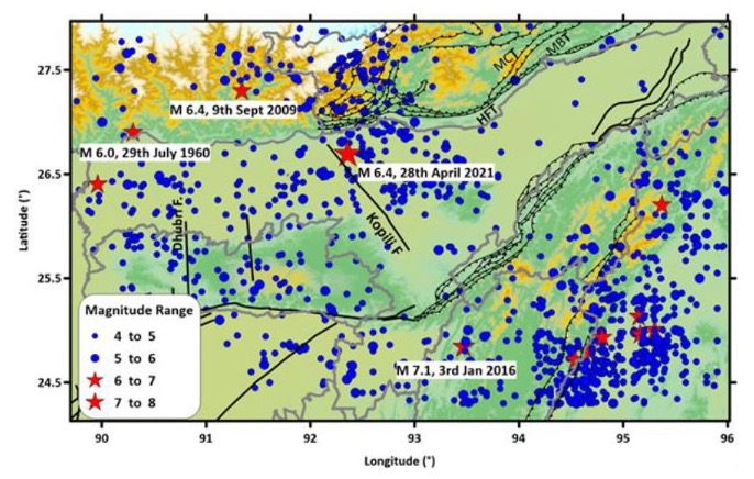
A quake in the Himalayan foothills
The state of Assam lies in the northeastern arm of India, sitting south of the mountainous country of Bhutan and the rugged Indian state of Arunachal Pradesh. Nevertheless, Assam feels the effects of convergence between the Indian and Eurasian tectonic plates that drives up the mountains. The southernmost Himalayan thrust fault — the type of fault that successively built the Himalayan range by shoving Eurasia over India — defines the boundary between the two plates. The surface expression of this boundary, interchangeably called the Himalayan Frontal Thrust or the Main Frontal Thrust, runs through the northern part of Assam and has hosted several major earthquakes in the past, whereas relatively minor faults splice the state at different orientations.
The Shillong Plateau, which lies south of Assam, complicates the region compared to other parts of the Himalayan range. According to Byron Adams, a Royal Society Dorothy Hodgkin Fellow at the University of Bristol, “It’s possible that the Indian plate behind the Shillong Plateau, which includes Assam, has low flexural strength, so it doesn’t bend easily under the load of either the overriding Eurasian plate or sediment coming from the rivers draining the range.” Instead, this part of the Indian plate breaks, with numerous faults slicing through the region at irregular angles, he says. “There may be more heterogeneities in the Indian crust in the east, so as the plate tries to subduct, it breaks instead of bending, creating more northwest-trending faults between the Himalayan range and the Shillong Plateau.”
Because of the numerous active faults crisscrossing the region, the NCS classifies this area within its zone of highest seismic hazard (Zone 5).

The Kopili Fault
The mainshock likely struck near the Kopili Fault, according to a preliminary analysis by the NCS. This fault trends in a northwest-southeast direction, indicating it is a “minor” fault, though it’s still capable of substantial seismic activity. Scientists believe this fault hosted the 1869 magnitude-7.5 Chachar earthquake and the 1947 magnitude-7.3 Hajoi earthquake (Sutar et al., 2017). This fault may have played a role in a 1941 magnitude-6.5 event (Kayal et. al., 2010).
According to Supriyo Mitra, a professor at the Indian Institute of Science Education and Research Kolkata Seismological Observatory, the Kopili fault zone moves with right-lateral strike-slip motion, meaning that the northeastern side of the fault moves to the southeast along a very steep fault surface. For reference, this is the same sense of motion along the famed San Andreas Fault. As the Shillong Plateau moves northward, says Mitra, that movement may be accommodated by the Kopili Fault zone.
Adams points out that the focal mechanism produced by the United States Geological Survey indicates a substantial thrust component, along with right-lateral movement. “If you put some right-lateral shear on those northwest-trending faults between the Himalayan range and the Shillong Plateau, you might expect something like what just happened in Assam.”
Find an updated earthquake hazard zone map here
References
Kayal, J. R., Sergei S. Arefiev, Saurabh Baruah, Ruben Tatevossian, Naba Gogoi, Manichandra Sanoujam, J. L. Gautam, Devajit Hazarika, and Dipak Borah. “The 2009 Bhutan and Assam felt earthquakes (Mw 6.3 and 5.1) at the Kopili fault in the northeast Himalaya region.” Geomatics, Natural Hazards and Risk 1, no. 3 (2010): 273-281.
National Centre for Seimology Report on 28th April 2021 Earthquake (M 6.4), Sonitpur, Assam, https://seismo.gov.in/sites/default/files/pressrelease/Assam_EQ_Report_28Apr2021.pdf
Sutar, A. K., Verma, M., Pandey, A. P., Bansal, B. K., Prasad, P. R., Rao, P. R., & Sharma, B. (2017). Assessment of maximum earthquake potential of the Kopili fault zone in northeast India and strong ground motion simulation. Journal of Asian Earth Sciences, 147, 439-451.
Further Reading
Clark, M. K., & Bilham, R. (2008). Miocene rise of the Shillong Plateau and the beginning of the end for the Eastern Himalaya. Earth and Planetary Science Letters, 269(3-4), 337-351.
- Venezuela’s doublet leaned toward Caracas - June 30, 2026
- Is Southern California’s Cajon Pass an ‘earthquake gate’ ready to open? - June 29, 2026
- Philippines magnitude 7.8 shock may have loaded the central Cotabato subduction zone - June 11, 2026