By: Deborah Kilb, Ph.D., Project Scientist, Scripps Institution of Oceanography (@Kinect_with_Sci), and Frank Vernon, Ph.D., Researcher, Scripps Institution of Oceanography
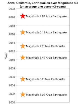
Over the last 20 years, the Anza area has hosted six quakes over magnitude-4.5, including last Friday’s quake. Most of these mainshocks did not produce large aftershocks, perhaps because the fault zone is unusually wide and fractured.
Citation: Kilb, D. and Vernon, F. (2020), Southern California jolted by moderate but intense quake, Temblor, http://doi.org/10.32858/temblor.084
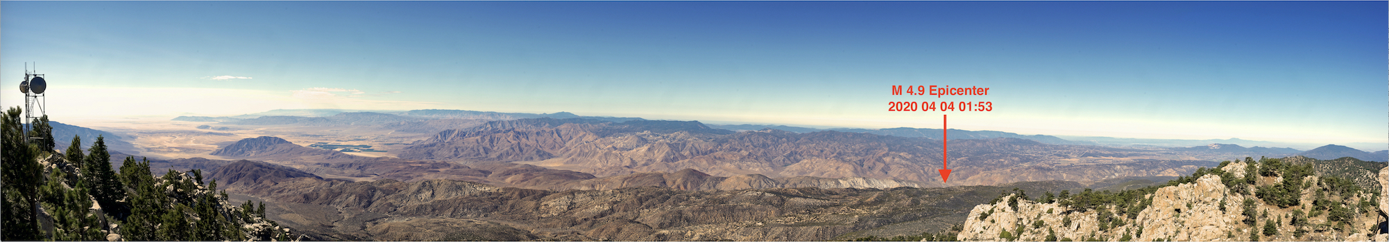
A magnitude-4.9 earthquake struck on April 3rd around 7 pm local time near the town of Anza, CA, when residents were in day 15 of the COVID 19 “stay at home” order. Reports came in of an intense earthquake, unlike the “slow-rollers” that many were accustomed to. This earthquake packed a punch, giving a good walloping shake to the region.
Normal earthquake behavior
The magnitude 4.9 Anza earthquake originated at approximately 6.5 miles (10.5 kilometers) depth according to the United States Geological Survey (USGS). The quake occurred on the Clark fault, a segment of the San Jacinto fault zone, which runs parallel to the San Andreas for ~130 miles (210 kilometers) through southern California.
Although the energy intensity produced by the earthquake was unexpected, the timeline and earthquake size were not. Over the last ~20 years the Anza region has experienced six earthquakes over magnitude 4.5, occurring approximately every three years. 20 years is a relatively short snapshot of the history of the fault zone however and this pattern of recurrence is not necessarily indicative of a long-term trend, nor does this offer any means to predict future quakes.
Abnormal earthquake behavior
The intensity of the earthquake was anything but normal. Scientists measure earthquake intensity using the Modified Mercalli Intensity scale, which is often reported using roman numerals to avoid confusion with earthquake magnitude. An earthquake of intensity II is only felt by a few people whereas an earthquake of intensity VI is strong and felt by many.
Intensity vs. magnitude
An earthquake has one magnitude–like a lightbulb that has a given wattage, that wattage will not change. The intensity of the lightbulb close-up will look brighter than it would farther away. Adding a cone lampshade can produce more intense light in one direction, while shadowing the intensity in the other direction. Similar effects can happen in earthquakes if the energy primarily propagates in only one direction, producing greater intensities in the earthquake propagation direction.
Friday’s quake was high intensity
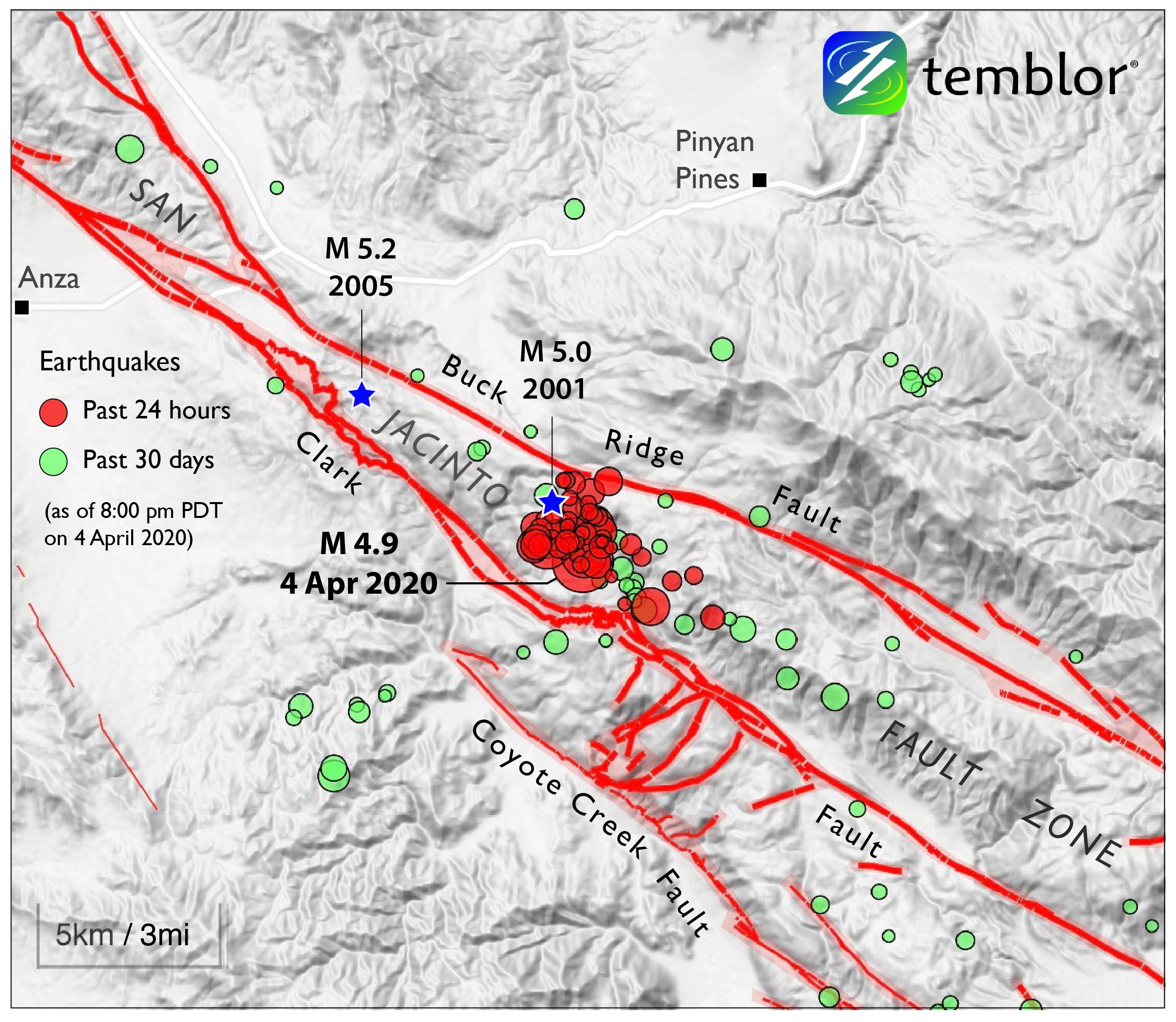
According to the USGS ShakeMap, Friday’s magnitude 4.9 earthquake produced a maximum Modified Mercalli Intensity of VI. The highest intensities were north of the mainshock, suggesting the earthquake generated more energy toward the north than elsewhere.

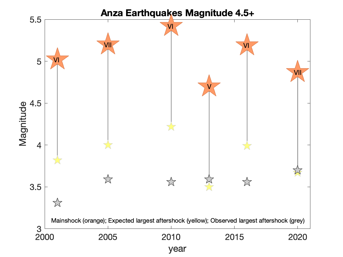
Importantly, earthquake intensity does not always scale with earthquake magnitude. Of the six largest earthquakes near Anza within the last two decades, Friday’s magnitude 4.9 earthquake ranks fifth largest, but the intensity of the quake is tied for the largest.
Large aftershocks or not?
Scientists expect that for any given earthquake, the largest aftershock will be 1.2 magnitude units smaller than the mainshock. For example, following the March 18, 2020 magnitude 5.7 Magna, Utah, earthquake the largest aftershock was magnitude 4.6, very close to the expected 4.5 value (5.7-1.2=4.5).
We find this to be approximately true for the Anza region’s 2013 and 2020 earthquakes, although at this point the largest aftershock for the 2020 quake is based on only ~7 days of data. In the weeks to come there could be a larger aftershock. We notice however, that for these 6 quakes, regardless of the earthquake magnitude or intensity, the largest aftershocks tend to be around magnitude 3.5, which is often lower than the predicted magnitude. This is a curious observation.
Extreme fault complexity
We suggest that it is the complexity of the fault system near Anza that is limiting the maximum magnitudes of the aftershocks here.
Within this region the San Jacinto fault zone is made up of three individual segments, rather than a single fault. In addition, smaller faults cut the landscape and are oriented perpendicular to the primary fault system (Ross et al., 2017). A map of the fault zone looks like a game of pick-up-sticks of multiple lengths.
It is this wide and ‘latticed’ fault structure that is likely inhibiting large aftershocks within the Anza region. Such a fault configuration indicates that stress heterogeneity also exists in the region (Garzon et al., 2016). This means that patches of high and low stress are intermingled within the region. Although there is no consensus on whether earthquake size is dictated by how an earthquake starts or by how it stops, research increasingly suggests the latter (Meier et al., 2017). Therefore, because the Anza region is peppered with low-stress regions¬–areas that limit earthquake propagation–it is easier to stop an earthquake rupture after it starts than it would be in a region uniformly under high stress. The result is relatively small magnitude aftershocks in Anza.
We don’t have enough data to know yet, but in 200 years someone should be able to test this hypothesis by validating this trend over the long term.
Concerned about your earthquake risk? Check it at Temblor.
Further Reading:
Ross, Z. E., Hauksson, E., & Ben-Zion, Y. (2017). Abundant off-fault seismicity and orthogonal structures in the San Jacinto fault zone. Science Advances, 3, e1601946.
Martínez‐Garzón, P., Ben‐Zion, Y., Abolfathian, N., Kwiatek, G., & Bohnhoff, M. (2016). A refined methodology for stress inversions of earthquake focal mechanisms. Journal of Geophysical Research: Solid Earth, 121(12), 8666-8687.
Meier, M. A., Ampuero, J. P., & Heaton, T. H. (2017). The hidden simplicity of subduction megathrust earthquakes. Science, 357(6357), 1277-1281.
Dr. Debi Kilb is a Project Scientist at Scripps Institution of Oceanography (SIO). In addition to her seismology research, she enjoys playing at the intersections of disciplines. She was the Science Director of the Scripps Visualization center (2002-2009) and the Director of SIO games (2014-2017), a group developing geoscience video games, and she enjoys teaching a ‘Music of Earthquakes’ class to middle schoolers.
Dr. Frank Vernon is a Research Seismologist at Scripps Institution of Oceanography (SIO). Over his career Dr. Vernon has worked on real-time sensor networks including the ANZA seismic network (1982-present), High Performance Wireless Research and Education Network (2000-present), USArray TA (2004-present), and the San Jacinto Fault Zone Project (2010-present).
- Venezuela’s doublet leaned toward Caracas - June 30, 2026
- Is Southern California’s Cajon Pass an ‘earthquake gate’ ready to open? - June 29, 2026
- Philippines magnitude 7.8 shock may have loaded the central Cotabato subduction zone - June 11, 2026