By Alka Tripathy-Lang, Ph.D. (@DrAlkaTrip)
The latest modeling shows that the interface between India and Eurasia may be segmented into pieces that can host earthquakes, and pieces that cannot.
Citation: Tripathy-Lang, Alka (2020), Slow moving fault pieces may limit large Himalayan quakes, Temblor, http://doi.org/10.32858/temblor.079
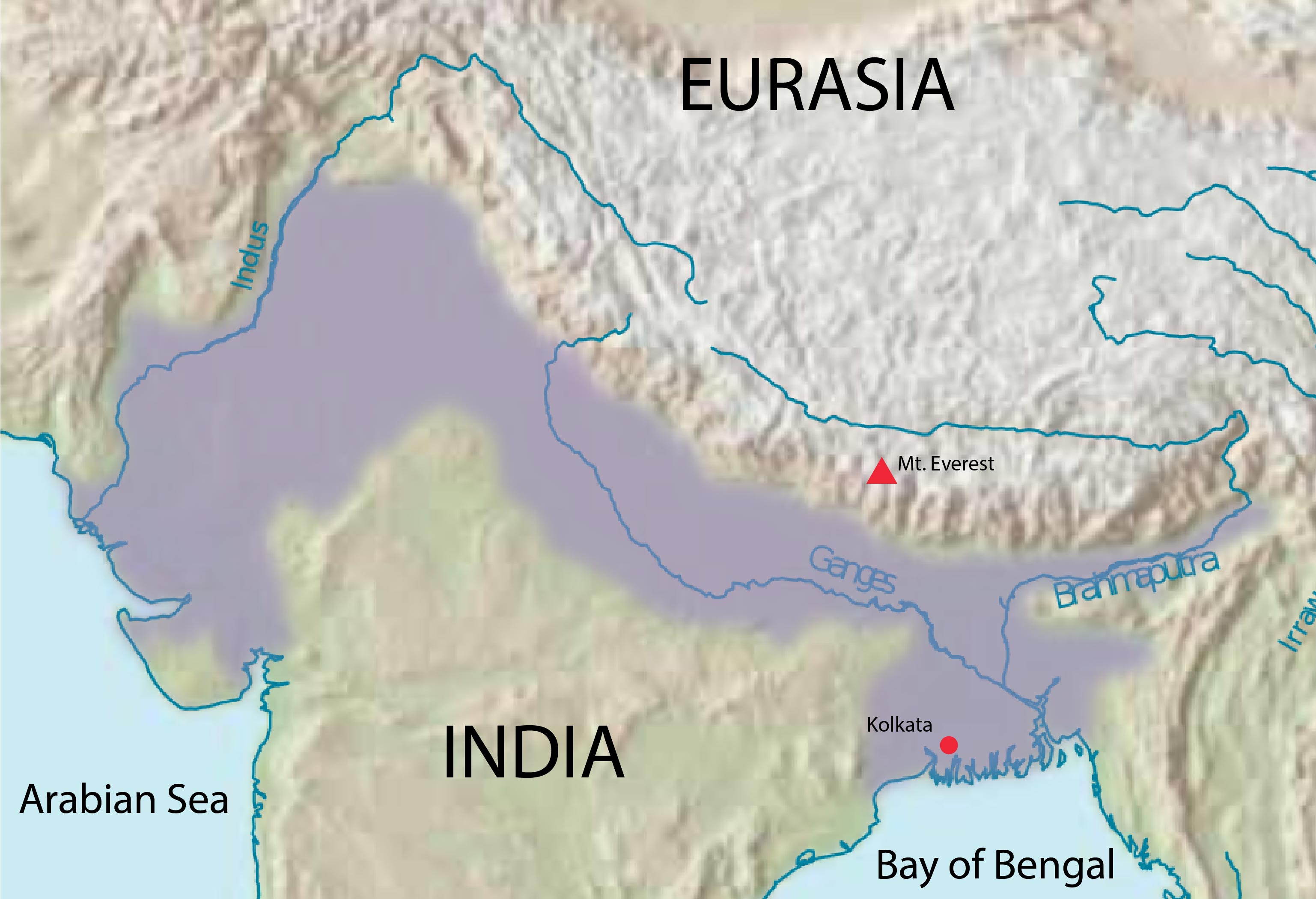
In the Indian city of Kolkata, the columnar steeple of St. Paul’s Cathedral presides over the 173-year-old structure. Its original cuspate spire toppled in 1934 during the magnitude-8.2 Bihar-Nepal earthquake, which ruptured near Mount Everest, more than 600 kilometers away.

Felt for hundreds of kilometers, the earthquake decimated villages in the Indian state of Bihar, home to almost 100 million people today. Understanding where seemingly far-off Himalayan temblors might strike is paramount for the safety of the 400 million people living in the densely populated Indo-Gangetic Plain that lies south of the mountains.
In a recent study in Geophysical Research Letters, scientists report that along the length of the interface between India and Eurasia, they’ve discovered locked, or stuck, sections of the fault separated by segments that creep languidly along. The plodding pieces may limit how far an earthquake can propagate, limiting the magnitude of future earthquakes.
Rising mountains, shaking ground
Millions of years ago, the vast Tethyan Ocean separated India from Eurasia. Initially closer to Africa, the Indian subcontinent careened northward as the Tethyan oceanic plate rapidly plunged beneath the Eurasian continent. When the Indian Plate finally smashed into the Eurasian Plate, India was jammed into the subduction zone and Eurasia was shoved on top. Since then, rocks have been stacking up, incrementally building the highest mountain range in the world—the Himalaya.
Cut-globe view of the continental collision between India and Eurasia from about 60 million years ago to present. Credit: Tanya Atwater, University of California, Santa Barbara
The interface between India and Eurasia is called the Main Himalayan Thrust, which scientists model as one big fault zone. It absorbs most of the convergence between India and Eurasia, representing the largest source of seismic hazard in the Himalaya and north India, says the study’s lead author, Luca Dal Zilio, a geophysicist Caltech. Across the range, he says, scientists estimate that India pushes northward continuously at a rate of between 13 to 20 millimeters per year.
If India and Eurasia continuously stack themselves at a rate equal to India’s northward movement, large earthquakes won’t rupture in such regions. However, if the interface is locked, Dal Zilio says, “every 60 years or so, the fault accumulates 1 meter of slip,” which needs to be released at some point. The stress built up by the interface being stuck, he says, eventually must be unleashed as an earthquake.
Modeling a fault
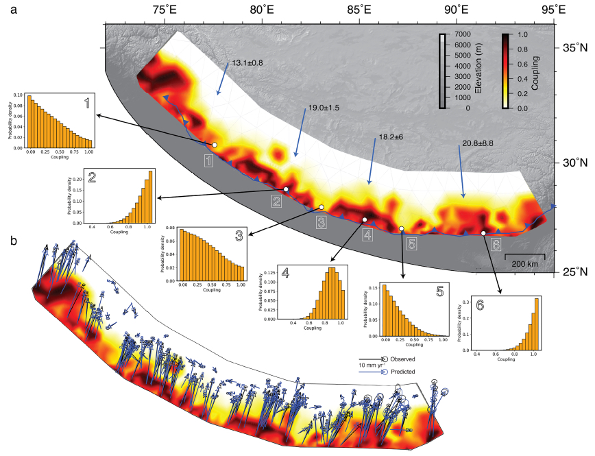
Dal Zilio and colleagues modeled motion along the fault through time to locate where the Main Himalayan Thrust is stuck, slowly moving, or something in between. He compared 360,000 iterations of his model to data from more than 280 global positioning system (GPS) stations throughout the Himalaya that show how India and Eurasia are moving today, and generated a map showing where the fault is most likely to be locked, or not.
Previous fault-modeling studies began with the assumption that the Main Himalayan Thrust was locked along the length of the range, says Dal Zilio, which can compel the model toward concluding that the fault remains locked today. His model did not presume the whole fault zone was locked—or even moves together as a single piece. This approach is potentially useful because the model results are “based on the data, and not on the assumptions,” says Victoria Stevens, a geophysicist at the University of Capetown in South Africa who was not involved in this study.
Locked segments, less hazard?
Instead of showing the range to be locked across its entirety, Dal Zilio’s map shows four locked segments separated by slowly slipping sections that are highly unlikely to host earthquakes. Further, if an earthquake begins in a locked section, Stevens says, “[it] may not be able to cross these seismic barriers.” This has significant ramifications for Himalayan countries, particularly with respect to infrastructure. “Barriers to rupture may change the pattern and level of hazard,” Stevens says, “which needs to be considered when placing infrastructure projects such as dams.”
However, Stevens says, although the earthquake barriers appear well constrained, they correspond to regions without GPS stations. These slowly-slipping seismic barriers may instead result from lack of data, and could, instead, be stuck—just like the rest of the fault. “Filling in the gaps in GPS coverage in these locations should be a priority,” she says. If there are patches where the fault isn’t locked, she says, “the patches could limit the size of an earthquake.”
Further reading
Bilham, R. (2019). Himalayan earthquakes: a review of historical seismicity and early 21st century slip potential. Geological Society, London, Special Publications, 483, 423-482. https://doi.org/10.1144/SP483.16
Dal Zilio, L., Jolivet, R., and van Dinther, Y. (2020). Segmentation of the Main Himalayan Thrust illuminated by Bayesian inference of interseismic coupling. Geophysical Research Letters, 47, e2019GL086424. https://doi.org/10.1029/2019GL086424
Nasu, N. (1934). The Great Indian Earthquake of January 15, 1934. Bulletin of the Earthquake Research Institute (Tokyo Imperial University), 13, 426. pdf.
Stevens, V.L. & Avouac, J.P. (2015). Interseismic coupling on the main Himalayan thrust. Geophysical Research Letters, 42, 5828–5837. doi:10.1002/2015GL064845.
- Living through the Loma Prieta earthquake - October 21, 2021
- The Great Quake Debate: an interview with seismologist and author Susan Hough - August 27, 2020
- Salton Sea Swarm quiets down - August 12, 2020