By Ali Moradi, Ph.D., Assistant Professor of Seismology, Institute of Geophysics, University of Tehran
I would like to thank Prof. Berberian for his valuable comments in “Tehran earthquake a wakeup call for the region”. However, I would like to clarify my comments, which were misquoted by IRNA news agency and then referenced by Prof. Berberian.
The multiple earthquakes in Iran in recent weeks, including the November 2017 Ezgeleh-Sar Pole Zahab Earthquake, and the earthquakes in the Kerman, Alborz and Tehran provinces in December 2017 were followed by widespread rumors on social media. These rumors were widely covered by news agencies reflecting controversial view points and sometimes misquoting the opinions of seismologists.
I was misquoted by the press
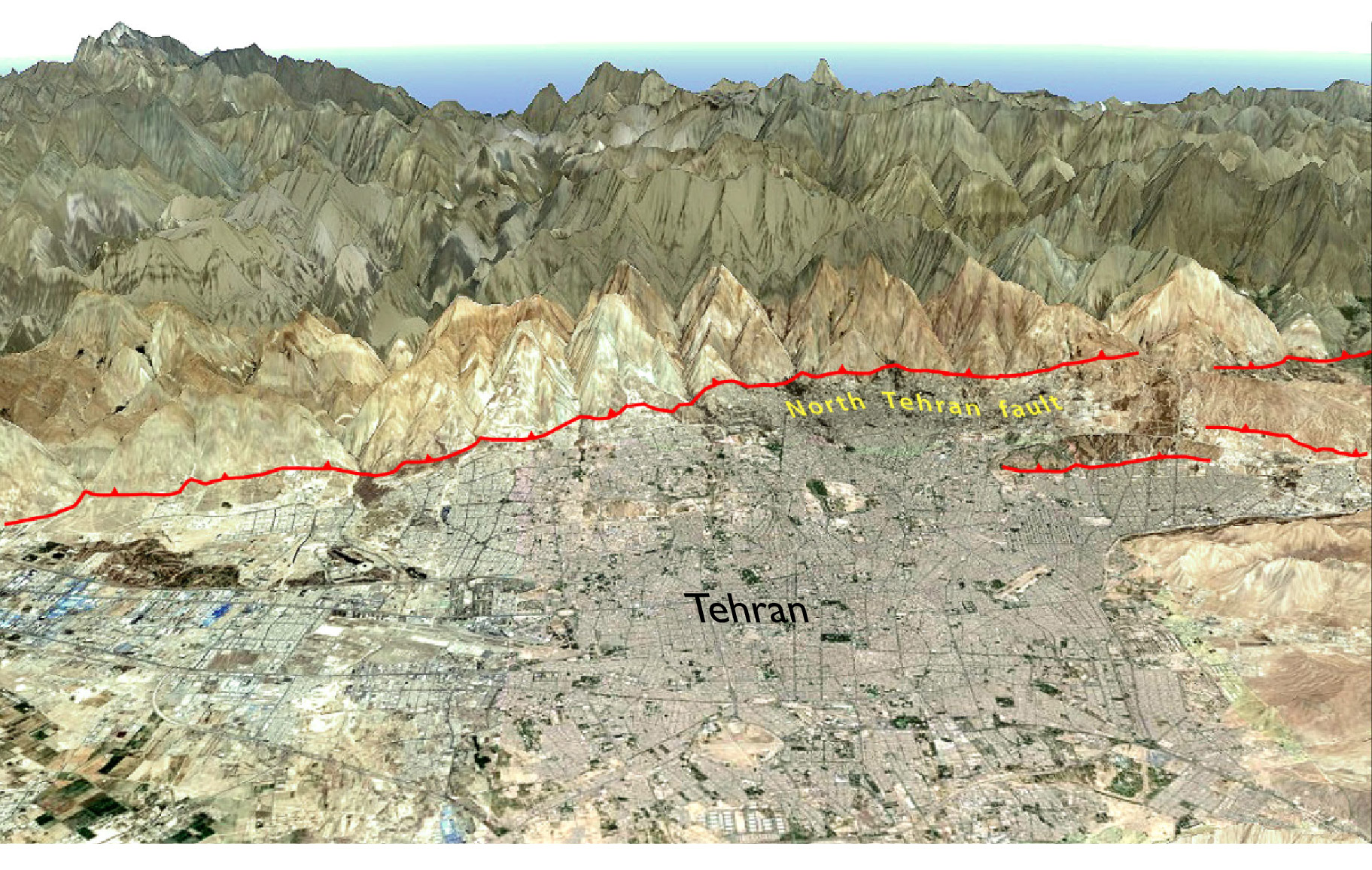
The IRNA news agency quoted me saying “the risk of a major earthquake in the capital city of Tehran has decreased.” I totally reject this because the magnitude of the earthquake outside Tehran is not even close to highest expected value for that region. The 20 Dec. 2017 Malard event, was a M=5.2, about two units smaller than the highest expected magnitude. Additionally, the epicenter was close to Eshtehard and the North Tehran fault zone where it has been more than 840 years since the last large event. Based on these facts, no one could say that the possibility of a larger event has decreased. Therefore, the quote from IRNA that “the risk of a major earthquake in the capital city of Tehran has decreased” referenced by Prof. Berberian misrepresented my comments about the risk of earthquake in Tehran.
I want to clarify that since the Malard earthquake I never suggested there is nothing to be worry regarding the seismic risk around Tehran. My advice is, and will remain, to be cautious and prepared. I myself was worried as well and tried not to tell people wrongly. Here I would like to provide an overview of what happened after the Malard earthquake near Tehran and give a brief introduction to the Iranian Seismological Center and its activities.
Seismic monitoring in Iran
The Institute of Geophysics, University of Tehran (IGUT), established in 1957, is a scientific center operating the largest seismic network in Iran with 126 seismic stations (50 short periods and 76 broad bands). These stations are operated by the Iranian seismological center (IRSC), a national section of IGUT. Since 2015 there has been data sharing between IRSC and the International Institute of Earthquake Engineering and Seismology (IIEES) which improves the seismic station coverage and reduces location errors. Figure 1 shows the seismic stations operated by IRSC and IIEES. The data sharing with the Tehran municipality Disaster Mitigation and Management Organization (TDMMO), which operates a local accelerographic network in Tehran, contributes to the IRSC’s ability to detect microseismicity around Tehran. The IRSC earthquake catalog is high quality near major cities due to the deployment of short period local networks around major Iranian cities. The digital local seismic networks around Tehran and Tabriz have been operating continuously for about 22 years and the microseismiciy catalog around these cities are available. Since 2006 all the local networks of Iran have been merged to a single on-line nation-wide virtual network and many broadband stations have been added to this network.

The recent recorded seismic activity around the Tehran–Alborz provinces
An interesting point about the recent Malard earthquake at the boundary between the Tehran and Alborz provinces is that anomalous seismic activity close to Eshtehard fault zone was detected since 2017/10/23 and have been reported to national disaster mitigation organization (NDMO) specifically on 2017/12/13 (Figure 3). We did notify the responsible individuals in NDMO that occurrence time of earthquake is not predictable but it is obvious that preparation is highly recommended.
The 5.2 Magnitude earthquake at the boundary between the Tehran and Alborz province caused severe shaking and millions of people panicked. A 10-km-distance between the previous seismic anomaly and the 5.2 Magnitude earthquake as well as the seismici history of Eshtehard fault convinced me to caution people in the Tehran and Alborz provinces after the Malard Earthquake. These two provinces are home to more than 20 million people. I was worried about the possibility of a larger earthquake with a magnitude of about 6.0 based on the 10-km-gap between activated regions (Figures 2 and 3).
Response to the M=5 earthquake
On that busy night, I was the first person to appear on National TV (IRNN) at least twice, [link] and recommended that people stay in safe places that night. An hour or two after my comments, representatives notified me that my comments were too harsh. I have to say that if such an event happens again, I will repeat my cautions.

Living with earthquakes in Iran
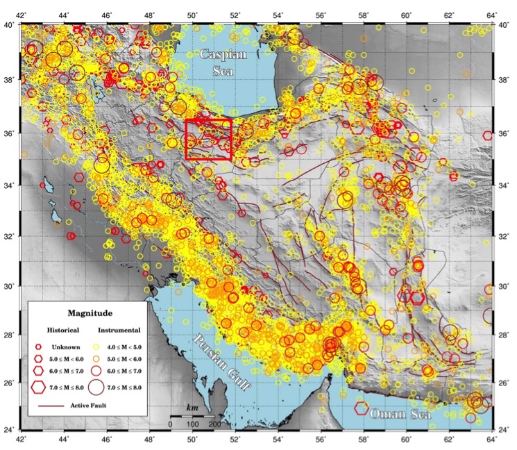
Iran is one of the most seismically active countries in the world. Fig.2 shows the historical and instrumentally-recorded events in Iran. A quick look at Iran’s recorded earthquakes shows very high seismic activity in some years, which could be repeated. For example between 1976 and 1981,Iran and its adjacent area was struck by 24 earthquakes with magnitude 5.8 and larger, three of which were above M=7 (USGS).
Therefore, we expect more seismic activity in Iran and we have to be ready. The casualties from earthquakes in Iran and the lack of knowledge towards recovery shows that Iran has a long way to go in order to be prepared. It is possible to minimize number of casualties by increasing readiness, basic training of citizens, installation and improvement of seismic sensors, earthquake early warning systems, GPS networks, and other instruments related to monitoring earthquake precursors. But, the main concern is existing buildings not capable of withstanding strong shaking. The solution to that is to construct better, safer buildings, and to follow existing building codes.
In the Malard earthquake, lack of knowledge of what to do in the event of an earthquake, resulted in people rushing into the streets, which created additional problems for rescue teams. In a seismically-active country like Iran, educating individuals about earthquake should start early and continue to higher education. History has shown that earthquakes are forgotten quickly in Iran and I hope this won’t be the case from now on.
Acknowledgement
I would like to thank Mr. Mohsen Dezvareh for providing the figures.
(Dr. Ali Moradi is writing as a professor and researcher of the University of Tehran, rather than as a governmental representative.)
References
Ambraseys, N.N. and Melville, C.P., 1982. A History of Iranian Earthquakes, Cambridge Univ. Press, Cambridge, 219 pp.
K. Hessami, F. Jamali and H. Abasi, “Major Active Faults of Iran,” International Institute of Earthquake Engineering and Seismology (IIEES), 2003.
Talebian, M., Ghorashi, M. and Nazari, H., 2009, Seismotectonic Map of Central Alborz, Research Institute for Earth Sciences, Geological Survey of Iran.
http://www.irna.ir/fa/News/82770623
http://www.ilna.ir/بخش-اجتماعی-5/572967-گسل-اشتهارد-فعال-شده-است-احتمال-وقوع-زلزله-پس-لرزه-وجود-دارد
https://m.youtube.com/watch?v=JDyHHGPV7Ig
- Earthquake science illuminates landslide behavior - June 13, 2025
- Destruction and Transformation: Lessons learned from the 2015 Gorkha, Nepal, earthquake - April 25, 2025
- Knock, knock, knocking on your door – the Julian earthquake in southern California issues reminder to be prepared - April 24, 2025