Researchers use precariously balanced rocks to reduce uncertainties in seismic hazard models for California’s Central Coast.
By Akash Kharita, Indian Institute of Technology, Roorkee
Citation: Kharita, A., 2020, Rocks ready to roll improve seismic hazard models, Temblor, http://doi.org/10.32858/temblor.136
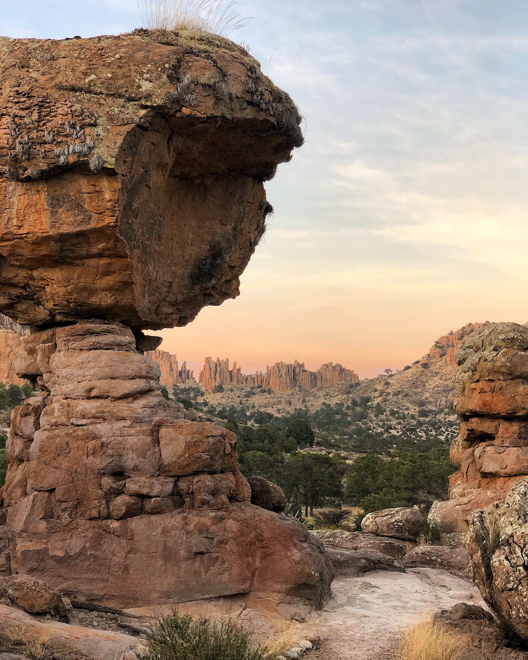
Have you ever seen a large rock delicately perched atop a natural pedestal, looking like it could topple at any time? As it turns out, such rocks may steady themselves in place for thousands of years. Their stability gives scientists a clue about how calm the ground has been since the rocks were so precipitously arranged.
A precariously balanced rock (yes, that’s the technical term) can form as weathering and erosion processes bring the rock to the surface, along with the underlying, more easily eroded rock upon which it sits. The lower rocks are worn away more quickly than the rocks above, and eventually, a narrow pedestal forms with a big rock on top that appears ready to tumble with the slightest shaking. In earthquake country, where Earth shakes with some regularity, scientists can constrain how strongly earthquakes rocked the ground by calculating how long the precariously balanced rocks have been perched.
In a recent study published in AGU Advances, a team from Imperial College, London, used geochronological and geometrical data from seven precariously balanced rocks near the Central California Coast to verify seismic hazard estimates in the region. The team learned that scientists may be overestimating how strongly the ground could shake when a future earthquake strikes this area.
Dating rocks with rays from space
To understand how long these precariously balanced rocks have survived in their perilous positions, Anna Rood, a doctoral student at Imperial College, London, and her colleagues used a geochronologic dating method based on the concentration of a cosmogenic radionuclide called beryllium-10 to determine the amount of time the rock has been exposed at Earth’s surface. The clock begins when the rock reaches the surface, whereby high-energy cosmic particles from space bombard it, interacting with specific minerals within the rock to produce beryllium-10 at a constant rate. “By counting the beryllium-10 atoms in the rock samples” the team collected from the precariously balanced rocks, Rood says, “we found the mean ages of [the rocks] to be approximately 20,000 years.” This finding provides an upper limit on the maximum level of ground shaking that might have occurred during the past 20,000 years at this particular study site, she says.
Though scientists have dated precariously balanced rocks before, Rood says that she and her co-authors have gone a step further than previous work by rigorously dating all seven precariously balanced rocks in their study area, as opposed to relying on fewer dates from a given site, as earlier studies had done. They also combined the dates and metrics of how fragile each rock is, and used this to validate a seismic hazard model called probabilistic seismic hazard analysis, which, she notes, has not been done before.
Probabilistic seismic hazard analysis
Probabilistic seismic hazard analysis estimates the maximum level of shaking that can occur in a given region. The U.S. Geological Survey hazard models for California use probabilistic seismic hazard analysis, which relies on estimates of the maximum level of expected ground shaking from an earthquake for a given length of time. In this type of model, how much the ground shakes and moves in any area depends mainly on the number and types of faults and what the ground consists of. For example, unconsolidated sediment shakes more than solid rock.
Uncertainties in some models that use probabilistic seismic hazard analysis include hidden, unknown faults buried deep underground whose contributions might be overlooked, and slowly moving faults whose contribution to the model may be overestimated. “Limiting uncertainties in [probabilistic seismic hazard analysis] is important because [these models] guide societal decision-making, such as for building codes,” says Dee Ninis, an earthquake geologist at Seismology Research Center, Australia, who was not involved in this study. These codes, in part, ensure that buildings are designed and constructed to withstand strong shaking from earthquakes.
Overestimating hazards
Rood and her team used numerical simulations and 3D modeling of the preciously balanced rocks to calculate how much ground shaking would be needed to knock the rocks from their resting place, and combined that information with their beryllium-10 dates. Then, Rood and her colleagues compared those results to the maximum ground shaking estimated by current seismic hazard maps. They report a 27 percent decrease in the mean seismic hazard estimates. In other words, current seismic hazard estimates, upon which building codes rely, may be overestimated.
Rood is now building an improved seismic hazard model using additional data her team collected from precariously balanced rocks at various sites in Southern California. This “is an important step forward in broadening the use of [precariously balanced rocks] to improve the reliability and certainty of [probabilistic seismic hazard analysis] models,” Rood says.
Further Reading
Rood, A.H., Rood, D.H., Stirling, M.W., Madugo, C.M., Abrahamson, N.A., Wilcken, K.M., Gonzalez, T., Kottke, A., Whittaker, A.C., Page, W.D. and Stafford, P.J. (2020), Earthquake Hazard Uncertainties Improved Using Precariously Balanced Rocks. AGU Advances, 1: e2020AV000182. doi:10.1029/2020AV000182
Balco, G., Purvance, M. D., & Rood, D. H. (2011). Exposure dating of precariously balanced rocks. Quaternary Geochronology, 6(3-4), 295-303.doi: 10.1016/j.quageo.2011.03.007
- Venezuela’s doublet leaned toward Caracas - June 30, 2026
- Is Southern California’s Cajon Pass an ‘earthquake gate’ ready to open? - June 29, 2026
- Philippines magnitude 7.8 shock may have loaded the central Cotabato subduction zone - June 11, 2026