By Jason R. Patton, Ph.D., Ross Stein, Ph.D., and Volkan Sevilgen, M.Sc. Temblor

Hawai’i Earthquakes and Eruptions
Over the past week there has been a flurry of earthquake activity on the Big Island of Hawai’i. These earthquakes are related to the volcanic activity associated with Kïlauea magmatism. As magma rises and moves within the magma chamber, we can infer the motion direction and velocity as earthquakes respond to these changes in magma pressure. At the time we write this, there have been over 900 shallow depth earthquakes reported on the U.S. Geological Survey earthquake website.

Below is a map that shows seismicity from the past week. Blue circles are located relative to the Pu’u ‘Ō’ō-Kupaianaha Volcano April 30 activity and the May 3 and May 4 fissure eruptions near the Leilani Estates (a residential subdivision near Pāhoa, Hawai’i). This area was evacuated and nobody was harmed. Several buildings were destroyed by fire. The seismicity also initially followed this eastward trend in motion. Initially, earthquakes were located to the west, but migrated to the east prior to the fissure eruptions. In addition, the lava lake formed in late April dropped in elevation prior to the fissure eruption (possibly due to the migration of magma from west to east). However, later seismicity migrated back to the west. This may be due to the changes in pressure associated with magma movement.

Hawai’ian Hotspot Volcanism
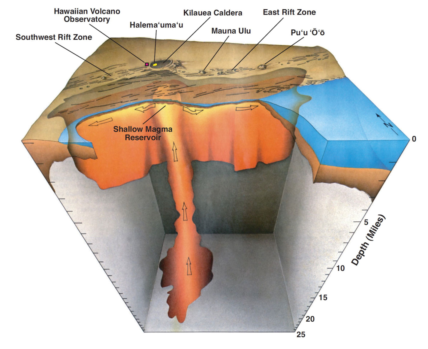
The Hawai’ian Islands are part of a chain of volcanoes and seamounts that are formed as the oceanic Pacific plate moves over a magmatic hotspot. This hotspot is a region where there exists a plume of upwelling magma that erupts through the Pacific plate to form volcanic eruptions. Over time, as the plate moves, the older volcanoes get further away from the hotspot. The most recent and currently volcanically active part of the Hawai’ian Islands is located on the Big Island of Hawai’i, where the Kïlauea volcano is located. Below is a visualization of how the magma chamber below Kïlauea may be oriented. Note how the magma plume rises to the Kïlauea Caldera, then spreads laterally to feed additional volcanic centers along the rift zones.
Hawai’ian Tectonics, Seismicity, and Eruptions
There are three main sources of earthquakes in Hawai’i: magmatic, volcanic edifice, and deep tectonic (IRIS). Magmatic earthquakes occur when magma rises or moves within the crust. As the magma rises beneath the volcanoes it can break up the crust. Changes in pressure and volume in the magma and volcano can increase the stress on faults in the region causing earthquakes.
There are faults within the volcanic edifice (the cone shaped structure that forms the shape of the volcano), as well as faults that exist beneath the volcano, between the volcano and the underlying Pacific plate. These faults can be sources of earthquakes independent of volcanism. Earthquakes in the volcanic edifice are extensional and caused by gravitational collapse of the volcanic rocks that form the edifice. These earthquakes tend to be small, with maximum magnitudes in the M 5 range. These extensional earthquakes may trigger earthquakes on the fault formed beneath the volcano. Earthquakes along this fault system can be much larger, including a M 7.9 Ka’u earthquake in 1868. A more recent example is the November 29, 1975 M 7.1 earthquake that happened near the current seismic and volcanic activity.
Earthquakes can occur within both the upper brittle mantle and oceanic crust as changes in pressure and temperature are exerted by the overlying volcano. The October 15, 2006 Kiholo Bay earthquake is an example of this type of earthquake. These are deeper than the other earthquakes, are further away from people and cause lesser shaking, for the same magnitude, than for shallower magmatic and volcanic edifice earthquakes.
The major fault systems on the southern part of the Big Island include rift zones and normal faults formed by extension either from gravitational collapse or extension related to the rift zones. The East Rift Zone and the Hilina fault appear to be the likely fault systems associated with this ongoing seismic activity. The 1975 earthquake may be a good analog to the current seismicity because it was also associated with magma injection.
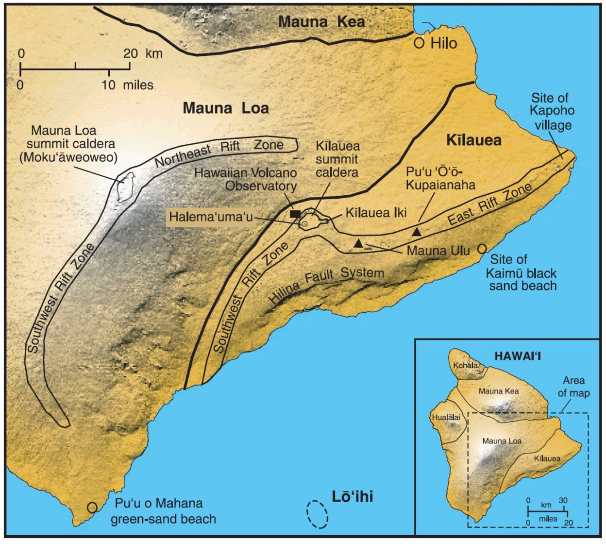
The current sequence of earthquakes began near the Pu’u ‘Ō’ō-Kupaianaha Volcano, where there is a crater formed from prior eruptions. This crater was filled with lava and the lava level reached the rim of the crater and overflowed the crater on 4/30/2018.
Tsunami
The 1975 M 7.1 earthquake generated a tsunami observed by tide gages located in Maui, Kauai, Hawai’i, and Oahu. Wave heights were up to several feet in Hilo and several inches high in Oahu. This tsunami was too small to have an impact elsewhere. The M 6.9 earthquake also generated a tsunami, but it was smaller than the 1975 tsunami. The Hilo tide gage shows a wave height of less than a foot (amplitude = 0.399 meter).

What is Next?
Using the 1975 earthquake as an analogy, the M 6.9 earthquake is possibly the main shock in this sequence. However, our historic record is only about 200 years long and we may not have enough knowledge to fully understand the entire range of possible outcomes. In terms of volcanism, this part of Hawai’i has eruptions on an almost ongoing basis. Below is a figure that shows the volcanic activity since 1780. Note that the USGS considers that we are currently in a period of continuous activity.

Here is another great map showing the relative volcanic hazard for the areas around the Big Island of Hawai’i. Severity of volcanic hazard is represented by color. The gray areas show regions where lava flows have happened in the past ~200 years. Note that the rift zones of Kïlauea are considered a region of increased volcanic hazard. So, if one resides or visits to regions of increasing severity of hazard, be prepared to respond to volcanic and seismic activity. Be prepared and know your hazard!

References
IRIS, Hawai’ian Islands: Origins of Earthquakes https://www.iris.edu/hq/inclass/animation/Hawai’ian_islands_origin_of_earthquakes
USGS, 2010. Eruptions of Hawaiian Volcanoes—Past, Present, and Future, U.S. Geological Survey, General Information Product 117, 72 pp.
Ando, M., 1979. The Hawaii Earthquake of November 29, 1975: Low Dip Angle Faulting Due to Forceful Injection of Magma in JGR, v. 84, no. B13
IOC Sea Level Station Monitoring Facility http://www.ioc-sealevelmonitoring.org/index.php
USGS HVO, Hawaiian Volcano Observatory https://volcanoes.usgs.gov/volcanoes/kilauea/
Additional background material can be found here: http://earthjay.com/?p=7350
- Earthquake science illuminates landslide behavior - June 13, 2025
- Destruction and Transformation: Lessons learned from the 2015 Gorkha, Nepal, earthquake - April 25, 2025
- Knock, knock, knocking on your door – the Julian earthquake in southern California issues reminder to be prepared - April 24, 2025