A moderate quake struck on a hypothetical shear zone that cuts through a sizable portion of Central Turkey.
By: Haluk Eyidoğan, Ph.D., Professor of Seismology, İstanbul Technical University
Citation: Eyidoğan, H., 2020, Moderate quake indicates large shear zone present in Central Turkey, Temblor, http://doi.org/10.32858/temblor.125
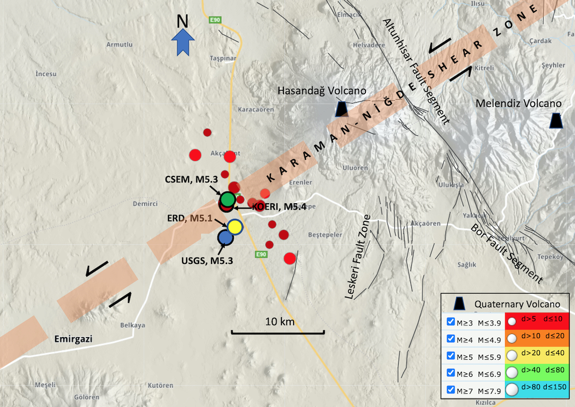
A magnitude-5.3 earthquake struck Central Turkey on September 20, 2020 near the Emirgazi District of Niğde Province. No resulting injuries or damage were reported. The quake struck in an area that has seen relatively little seismic activity in the past century. In fact, the area has not seen a moderate (magnitude-5.0) or greater earthquake in the past 120 years, which is odd in one of the most seismically active countries in the world. This quake has some scientists puzzling over its origins and wondering if it is evidence for a hypothesized shear zone.

A quiet region comes to life
The earthquake struck 12 miles (20 kilometers) from the Altunhisar segment of the Tuz Gölü Fault Zone — a major northwest-southeast trending fault zone that cuts nearly 124 miles (200 kilometers) across Central Turkey. This zone extends from north of Lake Tuz to Kemerhisar (Niğde). The earthquake epicenter also lies 9 miles (15 kilometers) from the extinct Hasandag Volcano and the Leskeri Fault Zone.
Despite these proximities, the quake’s location does not coincide with any known active faults. It does, however, lie along the northeast-southwest trending Karaman-Niğde Shear Zone hypothesized by Şengör and Zabcı (2019). This zone of diffuse left-lateral deformation once formed the boundary of an ancient microplate known as the Central Anatolian Ova Province. The location of this earthquake may suggest that this shear zone does indeed exist and is active.
The hypothetical shear zone is oriented roughly NE-SW, meaning that any faults present in the zone should have roughly the same orientation. Focal mechanisms calculated for the mainshock suggest the earthquake accomodated mostly strike-slip motion on either a left-lateral NE-SW or right-lateral NW-SE oriented fault, according to multiple seismic agencies. To determine which of these fault orientations is correct, seismologists often turn to the aftershock distribution. Aftershocks often occur along the same fault that ruptured in the mainshock and their distribution can sometimes elucidate the orientation of the fault that ruptured in the main event.
Aftershocks are key
Over 30 magnitude-3.0 and greater aftershocks have occurred since September 20, with most falling along a broadly NW-SE trend. Although the main earthquake location overlaps with the hypothetical shear zone, this pattern of aftershocks is not consistent with the orientation of the shear zone.
Only four seismograph stations exist within a 56-mile (90-kilometer) radius of the quake and the closest station is 21 miles (34 kilometers) away. This, and a poorly understood seismic velocity model, significantly affects the accuracy of the earthquake locations — not just latitude and longitude, but depth as well — in the region. Without a dense seismic network, scientists will need to use more advanced relocation techniques to determine exactly where the quakes in this sequence occurred. It is clear that more work is needed to determine whether this shear zone is present in Central Turkey and what role it plays in the earthquake hazard in this region.
Further reading
CSEM, 2020. https://www.emsc-csem.org/Earthquake/earthquake.php?id=904131
Emre Ö., Duman T.Y., Özalp S., Şaroğlu F., Olgun Ş., Elmacı H. & Çan T., 2016. Active fault database of Turkey. Bulletin of Earthquake Engineering. V. 16, 3229–3275.
ERD, 2020. https://deprem.afad.gov.tr/sondepremler
KOERI, 2020. http://www.koeri.boun.edu.tr/sismo/2/deprem-bilgileri/onemli-depremler/
Kürçer, A. & Gökten, Y. E., 2014. Neotectonic-period characteristics, seismicity, geometry and segmentation of the Tuz Gölü Fault Zone, Bulletin of the Bull. Min. Res. Exp., 149: 19-68, http://bulletin.mta.gov.tr
MTA, 2020. http://yerbilimleri.mta.gov.tr/anasayfa.aspx
Şengör, A. M. C., & Zabcı, C., 2019. The North Anatolian Fault and the North Anatolian Shear Zone. In C. Kuzucuoğlu, A. Ciner, & N. Kazancı (Eds.), Landscapes and Landforms of Turkey (pp. 481–494). Springer International Publishing. https://doi.org/10.1007/978-3-030-03515-0_27.
USGS, 2020. https://earthquake.usgs.gov/earthquakes/eventpage/us7000bqjg/executive
- Venezuela’s doublet leaned toward Caracas - June 30, 2026
- Is Southern California’s Cajon Pass an ‘earthquake gate’ ready to open? - June 29, 2026
- Philippines magnitude 7.8 shock may have loaded the central Cotabato subduction zone - June 11, 2026