The earthquake, which struck along Mexico’s Pacific coast, redistributed stress in the region.
By Hector Gonzalez-Huizar, Ph.D., Centro de Investigación Científica y de Educación Superior de Ensenada, Baja California (CICESE), Xyoli Pérez-Campos, Ph.D., Instituto de Geofísica, Universidad Nacional Autónoma de México (UNAM), California Institute of Technology (@xyolipc), and Diego Melgar, Ph.D., University of Oregon (@geosmx)
Citation: Gonzalez-Huizar, H., Pérez-Campos, X., Melgar, D., 2022, Mexico rattled by pair of earthquakes, Temblor, http://doi.org/10.32858/temblor.271
Este artículo también está disponible en español.
On Monday, a magnitude-7.7 earthquake struck near the town of Coalcoman in Michoacan, Mexico. This event was widely felt in different parts of the country, including Mexico City where the seismic alert from the Seismic Early Warning System of Mexico (SASMEX; Suárez, 2022) was activated and heard by many people a few seconds before the strong shaking started. The earthquake was also felt in northern Mexico.
In the 24 hours following the earthquake, more than 800 aftershocks were reported by the Mexican Seismological Service (SSN). On Wednesday, approximately 60 hours after Monday’s earthquake, a strong magnitude-6.9 aftershock occurred, activating the seismic alarm in Mexico City. It is very likely that strong aftershocks will continue occurring during the following days to weeks.

September 19 has become an iconic date for Mexicans in terms of earthquakes. On September 19, 1985, the deadliest earthquake in Mexican history — a magnitude-8.0 event — occurred. Despite official casualties counted at around 10,000, other organizations estimate that around 40,000 people may have died because of this earthquake, most of them in Mexico City. 32 years later, on September 19, 2017, a magnitude-7.1 earthquake caused great damage in Mexico City and nearby cities and killed around 370 people.
Every year on September 19, an earthquake drill takes place in various cities of Mexico in commemoration of the 1985 earthquake. In Mexico City, a seismic alert is broadcasted using public loudspeakers. In 2017, two hours before the magnitude-7.1 earthquake struck, the practice drill and alerts went out.
History repeated itself Monday, when the Coalcoman earthquake was felt in Mexico City some 45 minutes after the drill. The occurrence of these events has made many people in Mexico believe that September is the month of the earthquakes. However, multiple scientific studies — Aguilar (2021) and Ávila-Barrientos (2021), for example — have demonstrated that large earthquakes do not obey any date, month or season. When we analyze large catalogs of earthquakes, including those with very old historical events, we conclude that earthquakes have occurred in Mexico (and worldwide) in similar numbers during the twelve months of the year. Therefore, the probability of an earthquake occurring is totally independent of the date.
A history of large earthquakes
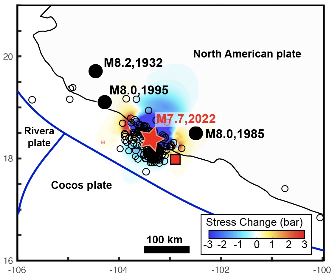
In Mexico, four earthquakes with magnitudes greater than or equal to 8 have occurred since 1900. The epicenter of this Monday’s Coalcoman earthquake was located very close to and between the epicenters of three of these large earthquakes. These earthquakes occurred along the Mesoamerican Trench, where the Rivera and the Cocos tectonic plates subduct underneath the North American Plate, and near a tectonic triple junction, where these three plates intersect.
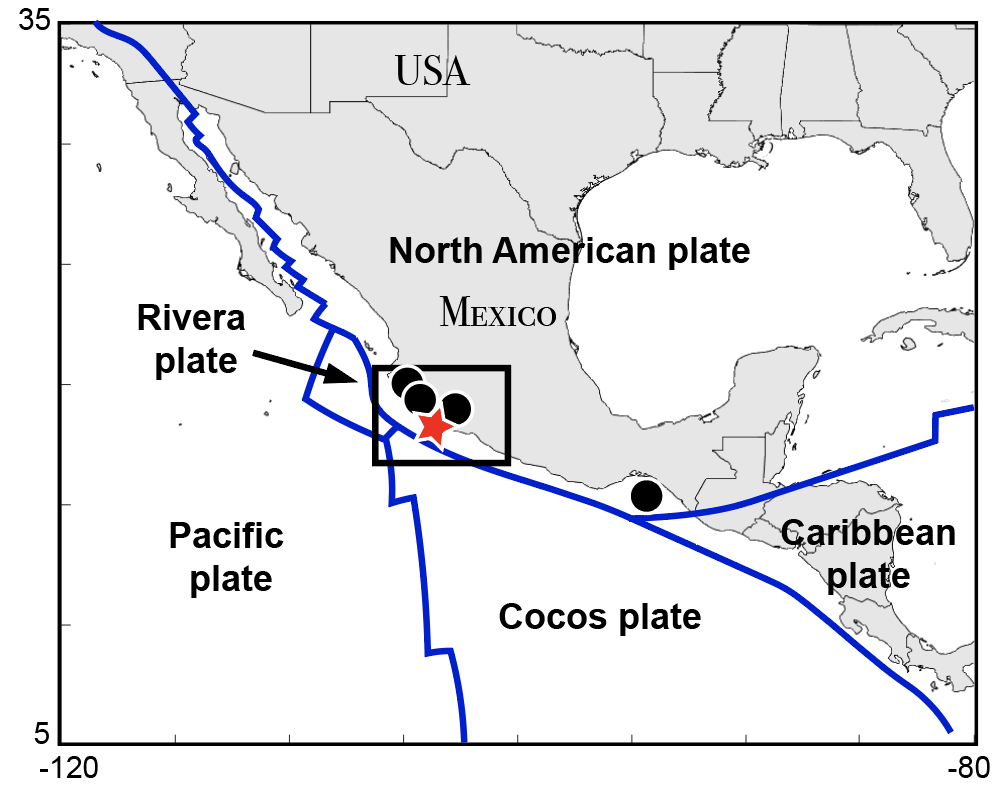
Geologically speaking, this is a very active region where volcanos, silent earthquakes, tectonic tremor and large magnitude earthquakes occur (Husker et al., 2019). Mexico’s western coast has seen more than 40 earthquakes greater than or equal to magnitude-7.0 in the last century. This week’s magnitude-7.7 earthquake seems to have ruptured a similar area as a magnitude-7.5 earthquake that occurred on January 30, 1973 (Reyes et al., 1979), and a magnitude-7.7 earthquake that struck on April 15, 1941 (Keller et al., 1973).
When an earthquake deforms the crust, the transfer of stress could unclamp a nearby fault and/or increase the stress acting on it. Such stress changes can either promote or hinder future earthquakes on these faults. We can calculate how this stress changed after the Coalcoman earthquake. This helps seismologists estimate where future earthquakes are more likely to occur (Toda et al., 2011). Red colored areas in the map below mark the places where stress has increased, and future earthquakes are more likely to occur. The Coalcoman earthquake might have increased the probability of future earthquakes at or very close to the rupture areas of the 1985 and 1995 (both magnitude-8.0) earthquakes.
A modest tsunami generated
Particularly important for the region are the impacts of tsunami waves from earthquakes such as these. The Coalcoman earthquake produced a modest amplitude tsunami, which lasted for more than 16 hours, as recorded by tide gauges operated in the region by the Servicio Mareográfico Nacional.
Though the peak wave amplitude was close to one meter at the city of Manzanillo, there are no water level gauges close to the epicenter. Larger amplitudes, possibly between two and three meters (seven to ten feet), are possible, but will need to be confirmed by a post-event tsunami survey. As a comparison, the 1995 magnitude-8.0 earthquake produced tsunami waves as large as five meters (16 feet) in the region (Borrero et al., 1997), causing significant damage.

Beyond identifying the hazard posed by large waves, tsunami observations are fundamental for understanding whether slip during Mexican earthquakes extend all the way to the surface along the trench.
When an earthquake occurring under the ocean slips all the way to the surface of the sea floor, the abrupt deformation caused at the sea floor can displace large volumes of water, causing a tsunami.
For most earthquakes in the Mexican subduction zone, it is widely accepted that fault slip does not extend to the surface, but stops at 10 kilometers (six miles) depth, reducing its potential to generate a tsunami. This could suggest that tsunami hazards are overall modest in the country. However, pre-instrumental events such as the 1787 magnitude-8.6 San Sixto earthquake and modern events such as the 1932 magnitude-8.2 Jalisco earthquake have produced large tsunamis that suggest larger slip areas are possible. Understanding the precise nature of shallow slip for the Coalcoman earthquake will be fundamental for future hazards assessments in the country.
References
Aguilar, M. (September 14, 2021) ¿Es septiembre realmente el mes de los sismos?, https://planeteando.org/2021/09/14/es-septiembre-realmente-el-mes-de-los-sismos/amp/
Ávila-Barrientos, L. (2021), Una revisión general acerca de las características y consecuencias de grandes sismos en México, GEOS, Vol. 41, No 2.
Borerro, J., Ortiz, M., Titov, V., & Synolakis, C. (1997). Field survey of Mexican tsunami produces new data, unusual photos. Eos, Transactions American Geophysical Union, 78(8), 85– 88. https://doi.org/10.1029/97EO00054
Husker, A., Frank, W. B., Gonzalez, G., Avila, L., Kostoglodov, V., & Kazachkina, E. (2019). Characteristic tectonic tremor activity observed over multiple slow slip cycles in the Mexican subduction zone. Journal of Geophysical Research: Solid Earth,1 24, 599–608. https://doi.org/10.1029/2018JB016517.
Kelleher, J., Sykes, L., & Oliver, J. (1973), Possible criteria for predicting earthquake locations and their application to major plate boundaries of the Pacific and the Caribbean, J. Geophys. Res., 78( 14), 2547– 2585, doi:10.1029/JB078i014p02547.
Reyes, A., Brune, J. N. & Lomnitz, C. (1979). Source mechanism and aftershock study of the Colima, Mexico earthquake of January 30, 1973. Bulletin of the Seismological Society of America, 69, 1819–1840.
Suárez G (2022) The Seismic Early Warning System of Mexico (SASMEX): A Retrospective View and Future Challenges. Front. Earth Sci. 10:827236. doi: 10.3389/feart.2022.827236
Toda, S., Stein, R.S., Sevilgen, V., & Lin, J. (2011), Coulomb 3.3 Graphic-rich deformation and stress-change software for earthquake, tectonic, and volcano research and teaching—user guide: U.S. Geological Survey Open-File Report 2011–1060, 63 p., available at https://pubs.usgs.gov/of/2011/1060/.
- Venezuela’s doublet leaned toward Caracas - June 30, 2026
- Is Southern California’s Cajon Pass an ‘earthquake gate’ ready to open? - June 29, 2026
- Philippines magnitude 7.8 shock may have loaded the central Cotabato subduction zone - June 11, 2026