Yesterday’s magnitude-5.1 quake in western North Carolina was felt throughout the southeastern U.S. Although it came as a shock, a quake of this magnitude is not unexpected.
By John E. Ebel, Ph.D., Senior Research Scientist, Weston Observatory of Boston College; Professor of Geophysics, Department of Earth and Environmental Sciences, Boston College
Citation: Ebel, J., 2020, Magnitude-5.1 earthquake rattles southeastern U.S., Temblor, http://doi.org/10.32858/temblor.109
It was Sunday morning a little before 8:30 am when my phone beeped with a text message. A friend in Greer, South Carolina had texted me to say that she and her husband had just felt an earthquake “around 8:10 am for ~5 seconds.” By then, I had already gotten alerts from my seismic monitoring system in New England that it had detected earthquake signals and from the UGSS that a magnitude 5.1 earthquake had taken place in western North Carolina. I immediately texted my friends with the initial information about the earthquake location, magnitude and felt area.
For many people, the magnitude-5.1 earthquake at 8:07 am EDT on 9 August 2020 was a surprise. The epicenter, just southeast of the town of Sparta, North Carolina, was not in any recognized seismic zone. It was nowhere near the well-known New Madrid seismic zone beneath the Mississippi River in the vicinity of western Tennessee, northeastern Arkansas, southeastern Missouri and western Kentucky. It was well away from the seismic zone at Charleston, South Carolina. It was almost 100 miles east of the northern end of the somewhat diffuse eastern Tennessee seismic zone.
The takeaway: this earthquake was a rare but not unusual occurrence in both its location and magnitude.
A quake in a diffuse seismic zone
The highest concentration of earthquakes in this part of the southeastern U.S. is contained within the eastern Tennessee seismic zone, approximately outlined in the blue box in the following map. In this zone, earthquakes are occurring between 3 miles and 15 miles below the earth’s surface. Scientists have a poor understanding of why there is a concentration of earthquakes here. The seismic events are taking place in deep, 1-billion-year-old basements rocks, below the surface rocks that had been pushed atop the basement rocks by more recent collisions of tectonic plate (Wheeler, 1995). This makes it difficult to study the earthquakes of this seismic zone.
Even less well understood by seismologists is another band of diffuse earthquakes that runs parallel the eastern Tennessee seismic zone — about 50-100 miles east, just east of the western boundary of North Carolina. To date, there have been no scientific studies of this less active band seismicity in North Carolina. Yesterday’s earthquake is at the northeastern end of this diffuse band of earthquakes.
If before yesterday I had been asked where North Carolina’s next magnitude 5.1 earthquake would take place, I would have said somewhere in this earthquake band in the westernmost part of the state.

Magnitude-5.0+ quakes do occur
From historical records, the largest earthquake that took place within the state of North Carolina was a shock on 21 February 1916. That earthquake was centered near Ashville, North Carolina in the western part of the state, and it caused some cracked plaster and chimneys in the area surrounding its epicenter. There are no seismographic recordings of this 1916 earthquake from which an instrumental measurement of the magnitude could be made. However, based on how far away residents reported shaking and the maximum intensity of shaking, scientists estimate this 1916 earthquake was a magnitude-5.2.
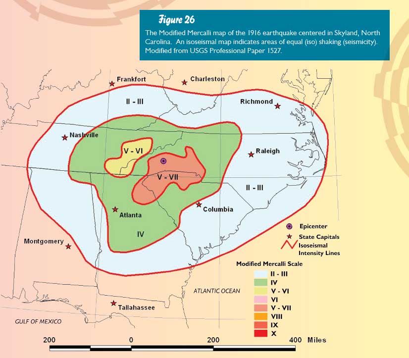
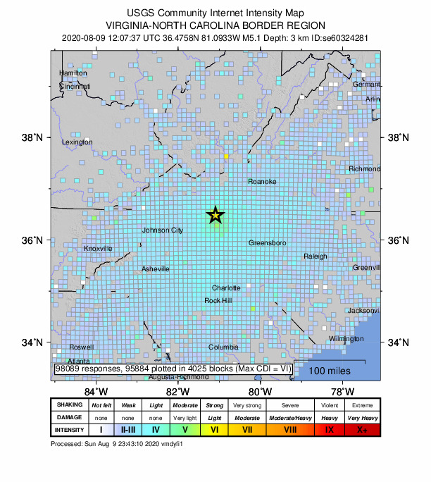
Both the 1916 earthquake and yesterday’s tremor were felt over roughly comparable areas to the northeast, east and south. However, the 1916 earthquake seems to have been felt more strongly in eastern Tennessee and farther west in Tennessee than yesterday’s earthquake. For both, the strongest ground shaking corresponded to about modified Mercalli VI to VII shaking, meaning potentially damaging to damaging shaking. These data indicate that the two earthquakes are of comparable magnitude, with the 1916 earthquake probably being slightly larger.
Two large quakes in just over 100 years
Despite evidence suggesting that the location and magnitude of yesterday’s quake is not out of the ordinary, the occurrence of this and the 1916 quake is only 104 years apart. Would one expect two earthquakes in western North Carolina of magnitudes 5.2 and 5.1 to be separated by 104 years?
We can estimate the average time between earthquakes of a given magnitude if we know the total number of earthquakes of any magnitude that have occurred in the same area, by way of something called a Gutenberg-Richter distribution. From this mathematical distribution, scientists calculate the average time between earthquakes of different magnitudes. The average time between magnitude 5.1 earthquakes in western North Carolina is 203 years.
Globally, the time interval between earthquakes can vary greatly around the average value from the Gutenberg-Richter distribution. For the San Andreas fault near Los Angeles, the average time between major earthquakes is about 140 years. However, the shortest time interval between the known large earthquakes over the past 2,000 years is 45 years, whereas the longest time interval is over 300 years. Thus, the 104 years that separated the 1916 quake and yesterday’s quake is not unexpected given the calculated average time and the known variations from average earthquake repeat times in other parts of the world.
Earthquakes occur within plate interiors
The vast majority of earthquakes of any magnitude in the world occur along tectonic plate boundaries. These are the sites at which great land masses are brought together, pulled apart, or slid past each other at immense pressure. But, about 10% of the earthquakes each year take place well away from any plate boundary, sometimes even in the middle of a plate.
Over four decades of high-quality instrumental seismic monitoring in the central and eastern U.S. has provided evidence these ‘intraplate’ earthquakes are caused by a slow squeezing of the interior of the North American plate. This squeezing is occurring because North America is being pushed away from Europe and Africa on its eastern margin and is pushing against the Pacific Ocean plate and some other small plates to its west. Like a clay brick in a vice that is being slowly closed, the interior of the North American plate is suffering occasional cracks as this squeezing pressure builds up. The cracks occur all over the plate interior, rather than being concentrated on just a few faults as is observed at boundaries. This makes identifying active faults in plate interiors very challenging for seismologists.
Although specific active faults are not yet mapped in most of the central and eastern U.S., there are some general trends in earthquake locations that have emerged that highlight areas where active faults must be present. Wheeler (1995) showed that many of the earthquakes along the east coast are taking place to the west of what he called the “Iapetan margin”. The Iapetan margin formed about 550 million years ago when the ancestral North American continental landmass split apart from what was then a single landmass comprised of all of today’s major continents. This video by paleogeographer and geologist Christopher Scotese of Northwestern University shows the movements of the plates starting at 540 million years ago. It shows that eastern North America collided with several different landmasses before 250 million years ago, and then it rifted from the continent of Pangea starting about 200 million years ago during Mesozoic time. All of these rifting events and plate collisions created many faults in eastern North America, only some which may be still seismically active today. Many of these old faults lie beneath more recent geological features and cannot be directly observed or mapped by geologists today, making it difficult for seismologists to study them.
Many of the earthquakes in eastern North America that occur today take place in the areas where the Iapetan rift faults and the later Mesozoic rift faults are found. Although seismologists still have much to do to verify this association between rift faults and modern earthquakes in eastern North America, the August 9 earthquake provides another data point for this line of research.
Concerned about your earthquake risk? Check it at Temblor
Further Reading
Dunn, Meredith M. and Martin C. Chapman. Fault orientation in the eastern Tennessee seismic zone: A study using the double-difference earthquake location algorithm, Seismological Research Letters, vol. 77, no. 4, pp. 494-504, July/August 2006.
Wheeler, Russell L. Earthquakes and the southeastern boundary of the intact Iapetan margin in eastern North America, Seismological Research Letters, vol. 67, no. 5, pp. 77-83, September/October 1996.
- Venezuela’s doublet leaned toward Caracas - June 30, 2026
- Is Southern California’s Cajon Pass an ‘earthquake gate’ ready to open? - June 29, 2026
- Philippines magnitude 7.8 shock may have loaded the central Cotabato subduction zone - June 11, 2026