By Gabriel Lotto, Temblor
This weekend, record-breaking rainfall in Louisiana and Mississippi caused extreme flooding in the region. As of this posting, eight people have died and over 30,000 have been rescued from their homes and cars during what state officials have called “historic” flooding. But just because a flood is large or historically significant doesn’t mean it’s unexpected.
Temblor just added flood risk maps in all U.S. states and territories to its web app, app.temblor.net
In most US counties, FEMA publishes maps of where flooding is likeliest. Where should we expect floods to happen in Louisiana? Almost everywhere, according to this Temblor map:
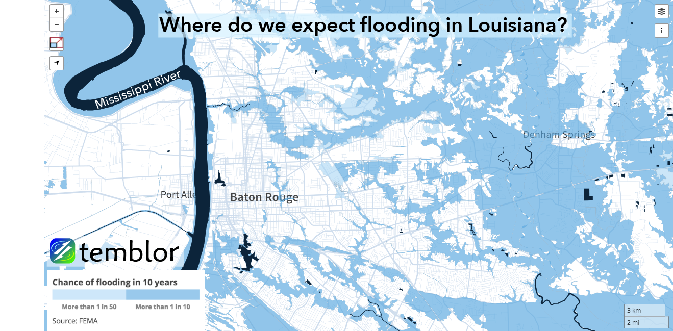
Louisiana and Mississippi are especially prone to flooding because they are largely built on low-lying marshes and alluvial floodplain (places where rivers deposit their sediments when they overtop their banks). Additionally, the Gulf Coast’s moist climate means that the soil saturates quickly during large rainfall events. Under normal conditions, soil absorbs rainwater like a sponge. But when the ground is fully saturated with water, excess rainwater stays on the surface and pools at the lowest elevations.
How well did FEMA’s maps predict this week’s Louisiana floods?
Let’s take a look at some examples. In Gonzales, LA, the East Ascension High School baseball field flooded while the track was largely unscathed. Indeed, the flood maps did a pretty good job of predicting where flooding would occur.

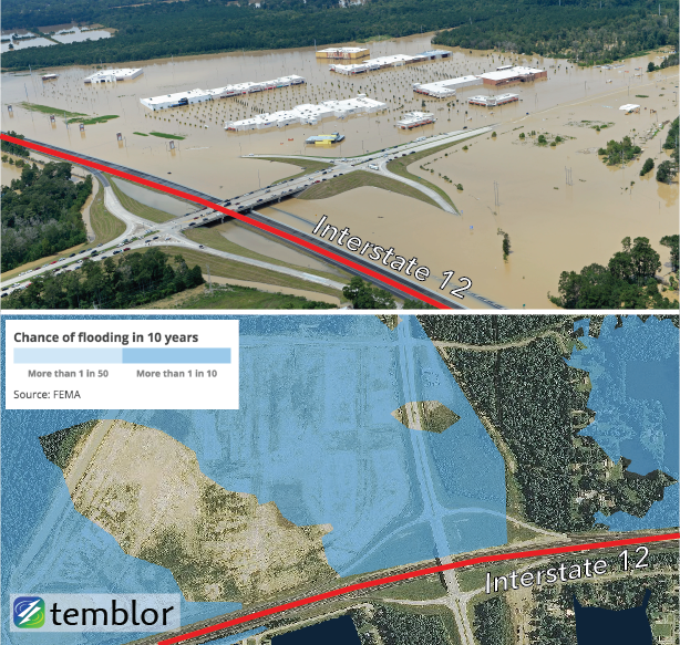
Another place the flood map was mostly accurate was in Denham Springs, at the Juban Crossing over the Interstate-12 highway. Here, the highway separates a flood zone from dry land, both in FEMA’s predictions and in reality. However, you can see that the 1% per year flood zone missed some of the areas that were inundated this week.
One final example of extreme flooding comes from Baton Rouge, where Airline Highway was hit with major floods just north of Greenwell Springs Road. Here, even the 0.2% per year flood zones were exceeded by the this week’s flood. This comparison makes the strongest case that the recent Louisiana floods are in fact historically significant.

Do you live in a flood zone?
Devastating floods like this week’s events in Louisiana are rare, but their occurrence shouldn’t be surprising. If you have a mortgage on a home located within the 1% per year flood zone, you are required to carry flood insurance. But historic flooding like this demonstrates that even if you live within the 0.2% per year flood zone or outside a flood zone altogether, your risk is not negligible and flood insurance may be a wise investment.
Temblor’s free web app allows you to view your flood risk anywhere in the United States. Simply visit app.temblor.net, enter in your location, click the layers button in the top-right corner, and select “Flood.” If you see no flood zones anywhere on the map, it may be because FEMA has not yet mapped that region. We will soon release our flood maps in the Temblor iPhone and Android apps as well.
Sources for Louisiana Floods
FEMA
Bill Feig Photography
“Interactive map: See Baton Rouge areas hit hardest by historic flooding over the weekend.” Advocate Staff Report, 12 Aug 2016. The Advocate.
Flood Insights
US Flood Maps: Do you live in a flood zone?
Click to read previous Temblor blog posts
- Earthquake science illuminates landslide behavior - June 13, 2025
- Destruction and Transformation: Lessons learned from the 2015 Gorkha, Nepal, earthquake - April 25, 2025
- Knock, knock, knocking on your door – the Julian earthquake in southern California issues reminder to be prepared - April 24, 2025