A magnitude-7.4 quake struck just offshore of Oaxaca, México this week. This and previous quakes highlight complex faulting and remind us of earthquake risk in the area.
By Aaron A. Velasco, University of Texas at El Paso, Xyoli Pérez-Campos, Servicio Sismológico Nacional (SSN), Instituto de Geofísica, Universidad Nacional Autónoma de México, Allen Husker, Department of Geophysics, Instituto de Geofísica, Universidad Nacional Autónoma de México, Marianne S. Karplus, University of Texas at El Paso, Hector Gonzalez-Huizar, Centro de Investigación Científica y de Educación Superior de Ensenada, Baja California, Solymar Ayala Cortez, University of Texas at El Paso
Citation: Velasco, A., A., Pérez-Campos, X., Husker, A., Karplus, M. S., Gonzalez-Huizar, H., Ayala Cortez, S., 2020, La Crucecita earthquake illustrates quake risk in México, Temblor, http://doi.org/10.32858/temblor.097
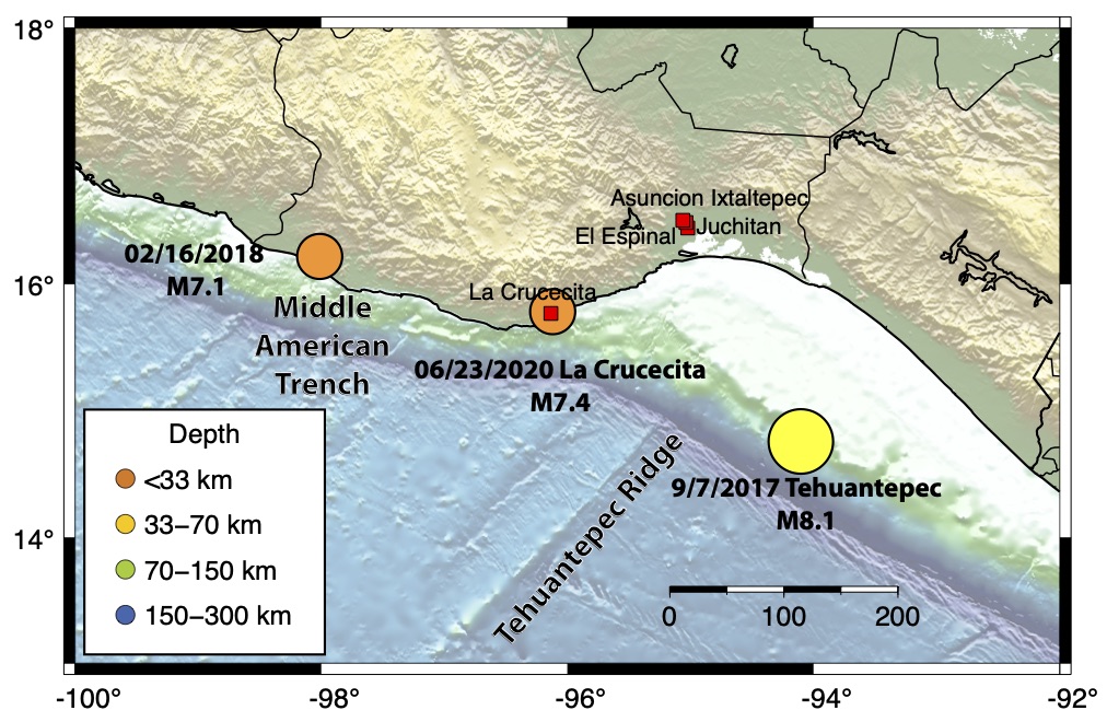
On June 23, 2020 at about 10:30 am local time, a large magnitude-7.4 earthquake struck the Pacific coast of Oaxaca, México, as reported by the Servicio Sismológico Nacional (SSN), UNAM, the national seismic authority in México. Strong shaking reached nearby cities, such as La Crucecita, Juchitán, El Espinal and Asunción Ixtaltepec — cities that remained heavily damaged from the magnitude-8.2 Tehuantepec quake in 2017.

Tuesday’s earthquake triggered the early warning system in México City, over 500 km away from the epicenter. Residents received an earthquake alert almost two minutes prior to the arrival of the seismic waves that shook buildings throughout the city. In the state of Oaxaca, at least six people were killed by the earthquake. Seven hospitals were damaged in different towns and in some of these, patients were evacuated. Reports of a small tsunami have been confirmed and initial estimates show that the nearby coast was uplifted about 1.6 feet (0.5 meters). In the 12 hours following the earthquake, the SSN had reported more than 1200 aftershocks, the largest — with a magnitude of 5.5 — occurred about 11 hours after the mainshock.
Tectonic plate boundaries produce big earthquakes
In this region, the Cocos Plate subducts beneath the North American Plate, creating a seismic and volcanic belt along the Pacific coast of Mexico. Tuesday’s earthquake occurred near this interface along the tectonic plate boundary known as the Middle American Trench, just offshore at a shallow depth 13.7 miles (22.6 kilometers) according to SSN. Preliminary estimates by the SSN and the United States Geological Survey show the earthquake occurred on a thrust fault oriented west-northwest, which is consistent with motion along this plate boundary interface.
A complex plate boundary
A number of factors contribute to the complex seismicity observed in this region. The Tehuantepec ridge, a remnant fracture zone related to the East Pacific spreading center, is being actively subducted beneath the North American Plate about 71.5 miles (115 kilometers) from Tuesday’s epicenter. This bathymetric high may play a role in the tectonic complexities of the region, as nearby the angle of subduction of the Cocos plate changes from shallow in the northwest to steep in the southeast.
Studies in the region show that slow-slip events — where an earthquake’s worth of energy and fault slip is released over a period of weeks to months — and weak vibration of the Earth’s crust occur along parts of this subduction zone. Seismologists are still trying to figure out whether these slow slip events could trigger large earthquakes.
Distant earthquakes cause shaking in Mexico City
Near the epicenter of a large earthquake, the shaking can be very strong, generating significant damage, as was observed in La Crucecita and other cities closest to the epicenter. Generally, seismic waves decrease in amplitude with distance from an earthquake epicenter and shaking diminishes. However, the soft sediments that comprise the México City basin act to slow and amplify these incoming waves. This, and the long duration of shaking created by distant but strong surface waves, can cause significant shaking in México City.
This earthquake was felt strongly in México City but fortunately, did not result in significant damage. The city has not been so lucky in the past and has suffered damage from distant earthquakes such as the 1985 magnitude-8.1 earthquake and the Morelos-Puebla magnitude-7.1 earthquake in 2017, 400 km and 50 km away from city center, respectively.
2017 Tehuantepec earthquake
On September 7, 2017, the magnitude-8.2 Tehuantepec earthquake struck offshore, around 125 miles (200 kilometers) southeast of the Tuesday’s epicenter. Unlike the thrust motion observed in this quake, the Tehuantepec earthquake ruptured the downgoing Cocos plate along a high-angle normal fault at ~28 miles (~45 kilometers) depth. The rupture propagated northwest at a relatively high velocity 2.1-2.24 miles per second (3.4-3.6 kilometers per second). Normal faults generally accommodate tensional force in Earth’s crust, rather than the compressional force expected when two tectonic plates are being pushed together in a subduction zone.
Aftershocks from a large earthquake usually outline the section of the main fault that ruptured because stress changes related to the main shock are often strongest closest to the area of the fault that ruptured. These stress changes cause a trickle of aftershocks in this area following a quake. The complexity of the Tehuantepec earthquake rupture is highlighted by the aftershock locations.

The La Crucecita earthquake occurred adjacent to the shallow, northern aftershocks of the Tehuantepec earthquake. This quake extends the seismically active region along the plate interface evident in the aftershocks from the Tehuantepec quake.
If the two earthquakes are related, the exact triggering mechanism must be further investigated, as earthquakes can be linked through the type of stresses that they create. For example, permanent deformation created by movement along a fault can increase or decrease stresses on adjacent faults, affecting the likelihood of future earthquakes. This stress usually diminishes within two fault lengths of a rupture. The Tehuantepec earthquake rupture length was approximately 75-125 miles (~120-200 kilometers), which could increase stress within about 250 miles (400 kilometers) of the epicenter. Preliminary analysis of the stress generated during the Tehuantepec earthquake shows an increase in the surrounding regions, including near the epicenter of the June 23 earthquake.

Further Reading
Husker, A., Frank, W. B., Gonzalez, G., Avila, L., Kostoglodov, V., & Kazachkina, E. (2019). Characteristic Tectonic Tremor Activity Observed Over Multiple Slow Slip Cycles in the Mexican Subduction Zone. Journal of Geophysical Research: Solid Earth, 124(1), 599–608. https://doi.org/10.1029/2018JB016517
Manzo, D. (2020), La Jornada, accessed 23 June 2020, https://www.jornada.com.mx/ultimas/politica/2020/06/23/sismo-de-7-5-deja-cinco-muertos-y-danos-a-viviendas-en-oaxaca-2101.html
Gonzalez-Huizar, H. (2019) La Olimpiada XXIV de Ciencias de la Tierra: Los Grandes Terremotos de México, GEOS, 39(1).
Perez-Campos, X., & Clayton, R. W. (2014). Interaction of Cocos and Rivera plates with the upper-mantle transition zone underneath central México. Geophysical Journal International, 197(3), 1763–1769. https://doi.org/10.1093/gji/ggu087
Suárez, G., Santoyo, M. A., Hjorleifsdottir, V., Iglesias, A., Villafuerte, C., & Cruz-Atienza, V. M. (2019). Large scale lithospheric detachment of the downgoing Cocos plate: The 8 September 2017 earthquake (M 8.2). Earth and Planetary Science Letters, 509, 9–14. https://doi.org/10.1016/j.epsl.2018.12.018
SSN (2020). Reporte especial: Sismo del 23 de junio de 2020, costa de Oaxaca (M 7.5). Servicio Sismológico Nacional, Instituto de Geofísica, Universidad Nacional Autónoma de México, México. URL: http://www.ssn.unam.mx
Toda, S., & Stein, R. S. (2015). 2014 M w 6.0 South Napa Earthquake Triggered Exotic Seismic Clusters near Several Major Faults. Seismological Research Letters, 86(6), 1593–1602. https://doi.org/10.1785/0220150102
- Venezuela’s doublet leaned toward Caracas - June 30, 2026
- Is Southern California’s Cajon Pass an ‘earthquake gate’ ready to open? - June 29, 2026
- Philippines magnitude 7.8 shock may have loaded the central Cotabato subduction zone - June 11, 2026