A burst of seventeen 1.0≤M≤3.2 earthquake struck 0.2 mi (0.5 km) east of the Calaveras fault trace, east of San José, California, on 29-30 March 2016 at about 5-6 mi (8-10 km) depth. The Temblor seismic hazard rank there is very high (98 out of 100), due largely to the convergence of the active Calaveras and Hayward faults, and to a lesser extent to the San Andreas.

The swarm lies near the southern end of the 1911 M=6.6 Calaveras fault earthquake as estimated by Diane Doser et al. (2009) from remote seismic data, and at the likely northern end of the 1984 M=6.2 Morgan Hill earthquake from much more accurate seismic and geodetic data (David Oppenheimer et al., 2010). The swarm also lies 2 mi (3 km) north of the 1984 M=6.2 epicenter. This proximity suggests that there is some kind of irregularity, bend, or break in the Calaveras fault at this location.
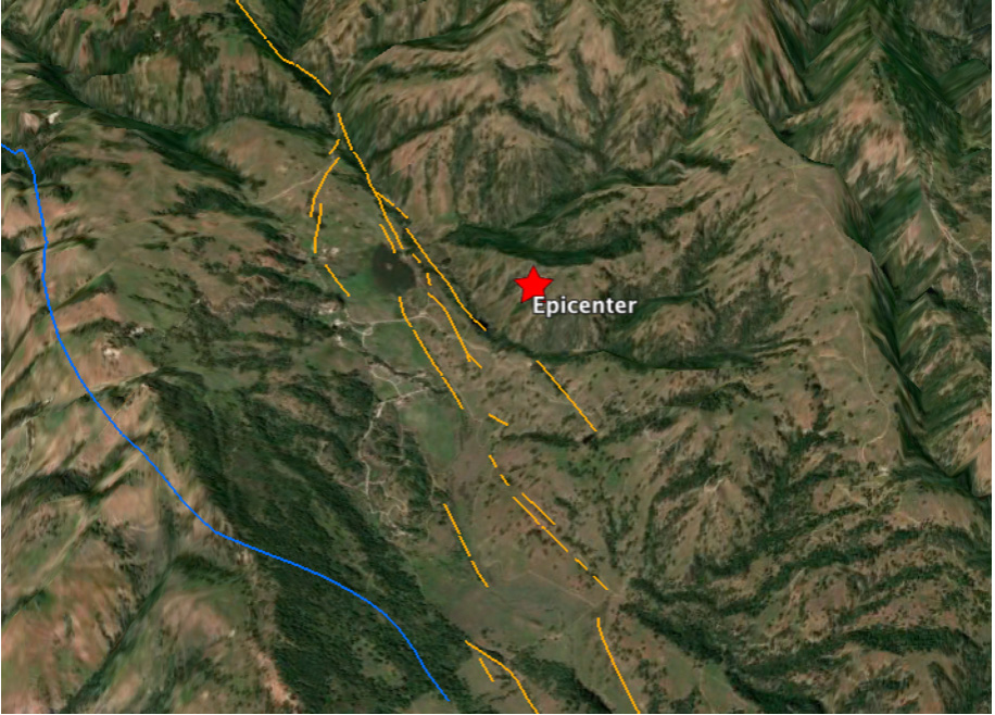
The Calaveras fault has a slip rate of 15±3 mm/yr in this location, and so the accumulated slip since 1911 is 5 ft (1.5 m), enough to permit another M=6.6 to strike in roughly the same location. Such an event, if it occurred, would strongly shake San José. Nevertheless, repeats of quakes in the same location and of the same size are rare, and so while possible, it is by no means expected.
Essential Data Lost to Science Forever
The 1911 quake, the only M≥6 event in the Bay Area during the 75 years after the great 1906 quake, struck in the ‘stress shadow’ of the 1906 earthquake, which imparted to that portion of the right-lateral Calaveras fault a 5-bar left-lateral stress. We wondered, could the 1911 event have been a ‘retrograde quake,’ in other words, with left-lateral slip on a right-lateral fault, something never before seen? So, our team, which was led by Diane Doser of the University of Texas at El Paso, needed to learn if there were surface rupture, and if so, in what sense; and we needed a seismic focal mechanism that could only be obtained by collecting seismograms in all quadrants, or in as many directions as possible from the epicenter, and as close as possible.

A Southern Pacific rail line and a major water main crossed the southern end of the likely rupture, and there was a newspaper report of a broken water pipe. But, the report did not describe how the pipe had broken, and the damage and repair records had since been discarded. The great Lick Observatory opened in 1888 on Mount Hamilton, just 4 mi (7 km) from the likely fault rupture, for which regular geodetic surveys (‘astronomic azimuth’ measurements) would have been needed to align the telescope, but these, too, were gone.
About a dozen U.S. seismic observatories logged the earthquake in their summaries, but we needed copies of the actual smoke-drum seismograms. UC Berkeley had a seismometer at the Lick Observatory, by far the closest. Perry Byerly, Berkeley’s great seismologist, removed the 1911 seismogram from the archive for study, but it was never returned.
In the early years of the century, most U.S. seismic observatories were run by scientist-scholar-priests at Jesuit universities. But by the time these professors began to die in mid-century, the universities had lost some of their scientific fervor, and the lifelong seismogram archives of the priests were most often thrown out. John Ebel, Chair of Earth Sciences at Boston College, home of the Weston seismic Observatory, generously helped us try to track the records down. But in the end, only one 1911 seismogram from the U.S., at the University of St. Louis, survived. We ended up relying on one seismograms from Ottawa, and two from Europe, to study a California quake—which proved most compatible with a conventional right-lateral mechanism.
Shameful.
Ross Stein and Volkan Sevilgen, Temblor
Data from USGS Calnet and
Doser, Diane I., Kim B. Olsen, Fred F. Pollitz, Ross S. Stein, and Shinji Toda (2009), The 1911 M∼6.6 Calaveras earthquake: Source parameters and the role of static, viscoelastic, and dynamic Coulomb stress changes imparted by the 1906 San Francisco earthquake, Bull.Seismol. Soc. Amer., 99, 1746–1759, doi: 10.1785/0120080305
Oppenheimer, David H., William H. Bakun, Tom Parsons, Robert W. Simpson, John Boatwright, and Robert A. Uhrhammers (2010), The 2007 M5.4 Alum Rock, California, earthquake: Implications for future earthquakes on the central and southern Calaveras Fault, J. Geophys. Res., 115, B08305, doi:10.1029/2009JB006683.
Do you live near the Calaveras fault? Check your home’s seismic risk at http://temblor.net
- Earthquake science illuminates landslide behavior - June 13, 2025
- Destruction and Transformation: Lessons learned from the 2015 Gorkha, Nepal, earthquake - April 25, 2025
- Knock, knock, knocking on your door – the Julian earthquake in southern California issues reminder to be prepared - April 24, 2025