Multidisciplinary research on archaeological sites in Israel suggests a different fault than originally thought damaged the city in the eighth century and may rupture again.
By Vanessa Vieites, science writer
Citation: Vieites, V., 2020, Ancient earthquake’s ruins may signal future quakes near Dead Sea Fault, Temblor, http://doi.org/10.32858/temblor.137
In the Israeli city of Tiberias, on the western shore of the Sea of Galilee, lies wreckage thought to be the result of a sequence of large earthquakes that occurred in the mid-eighth century. But a lack of measurements and instrumental data on earthquakes in the region before the 20th century has prevented researchers from designating the series of ancient quakes as the most probable cause of the damage at Tiberias. Using a combination of geological, archaeological and historical evidence, scientists have now found that normal faulting, including surface ruptures, along the Dead Sea are linked to the mid-eighth century earthquakes, suggesting that a similar seismic event could occur once again.

Strong shaking in the past
“The region is known for having had strong earthquakes in the past,” says Francesca Ferrario, an earth scientist at the University of Insubria in Italy and lead author of the new study in the journal Tectonics. That’s included quakes in the 8th, 11th, 18th and 19th centuries. But no strong quakes have occurred in Tiberias since the invention of modern instrumentation, Ferrario says. So, seismologists have classified Tiberias’ seismic risk based on literary sources and historical documentation of past quakes. However, having to rely only on paleoseismic proxies makes it difficult to pinpoint the precise position and number of past quakes and any associated damage, she says. Knowing what kind of damage past quakes had is important for categorizing current seismic risk.
Paleoseismology and archaeoseismology research
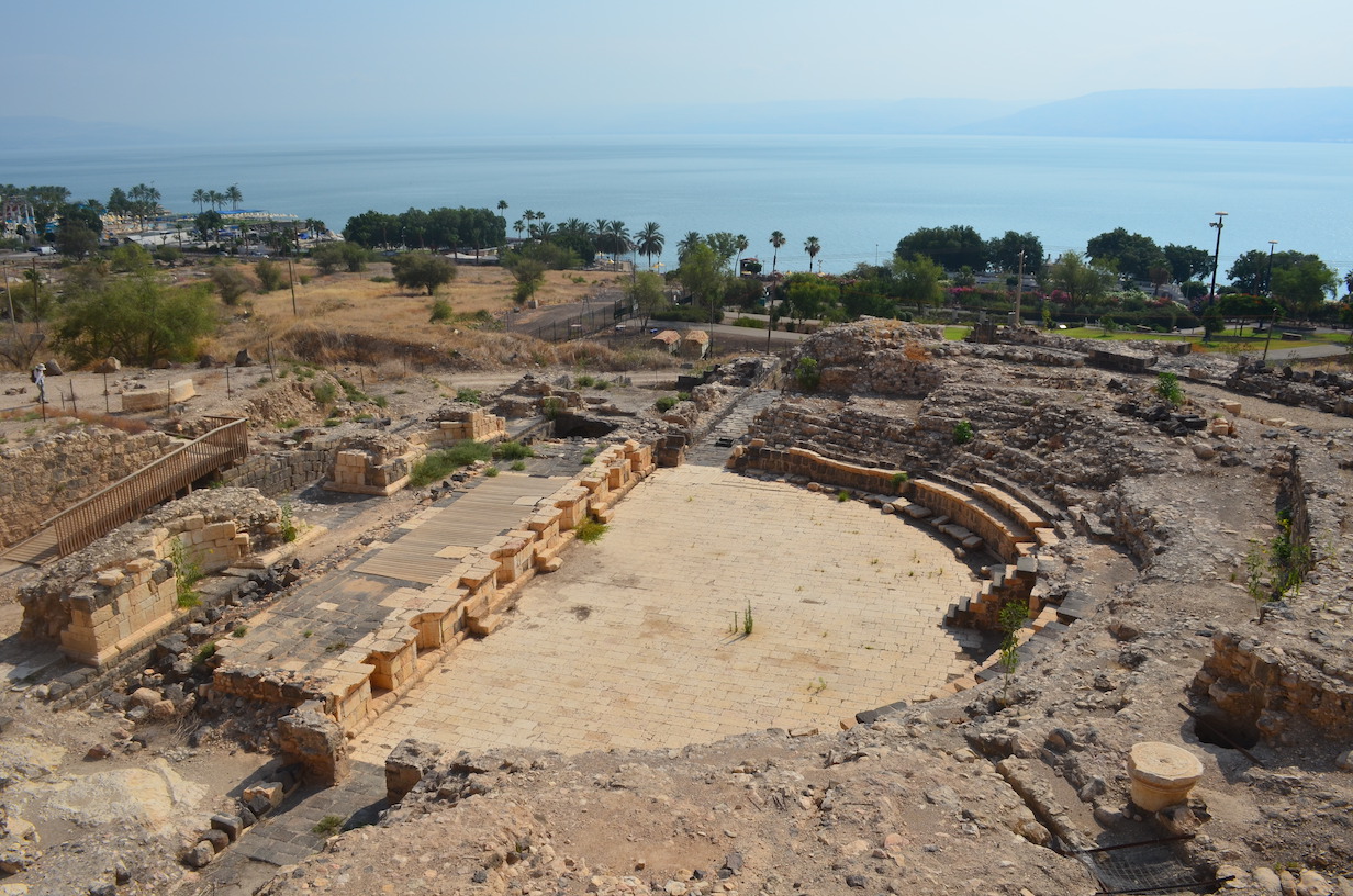
Ferrario and a team of geologists and archaeologists studied three sites that are most likely home to the remnants of the eighth-century earthquakes: an ancient Roman theater, the southern gate of the city and a water reservoir. The archaeologists analyzed and dated the ruins, finding that only the oldest part of the theater, built in the first century, was damaged by a surface rupture, indicating that the ancient earthquakes (and not more recent ones) were responsible for the wreckage.
The team’s geologists studied the geomorphology along the Sea of Galilee to characterize the faults and surface ruptures. They analyzed a digital elevation model of the region’s slopes, aspects and contour lines, along with 20th century aerial photos of the terrain. Next, the geologists mapped the features possibly connected to tectonic activity, such as cliffs or anomalies in river networks.
“From the geological site alone, we cannot say the damage is due to the earthquake,” Ferrario says. But using the archaeology with the geology helped them to ascribe the damage at Tiberius to strong seismic events in the mid-eighth century.
Which fault is at fault?
The faulting along the Sea of Galilee, namely the Dead Sea Fault to the east and the Jordan Valley Western Boundary Fault to the west, could make the city of Tiberias vulnerable to future earthquakes, Ferrario says. According to Ferrario, the two faults are connected but can move independently of one another or in synchronicity, with the potential to cause multifault ruptures, resulting in even bigger earthquakes than those caused by a single fault. A single rupture could cause a magnitude-6.9 event, the team reported, while a multirupture event could reach magnitude-7.6. Because the seismological literature already contains a substantial amount of scientific data on the Dead Sea Fault, the researchers focused their investigation on the Jordan Valley Western Boundary Fault, carefully surveying it in the new study.
“Our research is the first to document primary surface faulting associated with the mid-eighth century event,” says Ferrario, noting that the new study only implicates the Jordan Valley Western Boundary Fault rupture in the ancient earthquakes. Although it is possible that the Dead Sea Fault may have also been involved in the past seismic events, Ferrario says, scientists cannot say from the new study whether long ago the two faults ruptured alone (i.e., single-fault rupture) or together (i.e., multifault rupture). “The two faults have a different type of movement — normal vs strike-slip — which has implications in terms of risk assessment,” she adds.
Although the Jordan Valley Western Boundary Fault is shorter than the Dead Sea Fault, Ferrario says, it “poses a new potential risk” to Tiberias, which is closer to this fault. Surface rupturing on this fault, and the ability of this fault to rupture together with the Dead Sea Fault, causing bigger earthquakes, was not previously considered when assessing the risk of earthquakes in that region, she says.
Vulnerable Tiberias
The study “is a nice combination of archaeology and paleoseismology,” says Yan Klinger, director of the Tectonics Lab at the Paris Institute of Earth Physics, who wasn’t involved in the new work. The study “brings more evidence to the large corpus of data already existing along that fault system for past earthquakes,” he says, “and documents surface deformation for a specific site, helping to nail down the possible location of some of the fault sections involved in the [mid-eighth century] seismic crisis.”
“The Dead Sea Fault is a major plate boundary comparable to the San Andreas Fault in term of length, although slower, [slipping] at 5 millimeters [0.2 inches] per year compared to the San Andreas Fault, which [slips] at 35 millimeters [1.4 inches] per year,” Klinger says. The slow movement of the Dead Sea Fault, he adds, means that “the occurrence of large earthquakes is lower,” happening once every 400 to 600 years or more. Within the modern instrumental era, the only earthquake of notable size was the 1995 magnitude-7.3 Nuweiba earthquake, which affected the southern section of the fault, in the Gulf of Aqaba, he says. That quake damaged nearby settlements, caused a tsunami and killed 11 people (Frucht et al., 2019). The new study suggests that similarly intense, albeit infrequent, earthquakes may still occur in Tiberias. “[The 1995] earthquake is here to remind us that large, potentially destructive earthquakes happen along the Dead Sea Fault,” Klinger says.
Thus, Ferrario says, it is important for the municipality of Tiberias to know precisely where the potential surface ruptures along the faults lie so that policymakers can implement proper engineering practices to avoid a great deal of seismic damage if one or multiple faults rupture again.
Further Reading
Ferrario, M. F., Katz, O., Hillman, A., Livio, F., Amit, R., & Michetti, A. M. (2020). The mid‐eighth century CE surface faulting along the Dead Sea Fault at Tiberias (Sea of Galilee, Israel). Tectonics, 39, e2020TC006186. https://doi.org/10.1029/2020TC006186.
Frucht, E., Salamon, A., Gal, E., Ginat, H., Grigorovitch, M., Tov, R. S., & Ward, S. (2019). A Fresh View of the Tsunami Generated by the Dead Sea Transform, 1995 Mw 7.2 Nuweiba Earthquake, along the Gulf of Elat–Aqaba. Seismological Research Letters, 90(4), 1483-1493. https://doi.org/10.1785/0220190004
- Venezuela’s doublet leaned toward Caracas - June 30, 2026
- Is Southern California’s Cajon Pass an ‘earthquake gate’ ready to open? - June 29, 2026
- Philippines magnitude 7.8 shock may have loaded the central Cotabato subduction zone - June 11, 2026