What’s the relationship between July’s magnitude-8.2 quake off the Alaska Peninsula and last summer’s magnitude-7.8 Simeonof quake?
By Connor Drooff, Ph.D. Candidate, Michigan State University
Citation: Drooff, C., 2021, Alaska’s Chignik earthquake shows segmented subduction zone, Temblor, http://doi.org/10.32858/temblor.194
On Wednesday, July 29 at 6:15 a.m. UTC (10:15 p.m. local time on July 28), a magnitude-8.2 earthquake struck offshore of southwest Alaska. Located off the coast of the Alaska Peninsula about 115 kilometers southeast of the small town of Chignik, the earthquake ruptured a segment of the Alaska-Aleutian Subduction Zone, where the Pacific Plate continually pushes beneath North America. This seismically active region accommodates about 6 centimeters per year of convergence between the Pacific and North American plates. Each year, scientists detect thousands of earthquakes along the interface between these two plates, with the Chignik earthquake being the largest to have occurred in the area — and in the United States — since 1965, a span of just over 50 years.
Related quakes?
The Chignik earthquake has piqued scientific curiosity not only due to its size, but also due to its proximity to last summer’s magnitude-7.8 Simeonof earthquake that struck on July 22, 2020. A mere 54 kilometers separates the locations from which each event nucleated. The Simeonof event occurred in a region of the plate interface previously identified by researchers as a “seismic gap” — an area that has produced large earthquakes in the past but has since gone seismically “quiet.” It had been postulated since the 1980s (Davies et al., 1981) that this area of the plate interface referred to as the Shumagin Seismic Gap — named for the overlying Shumagin Islands — was due for an earthquake. The fact that this section of the subduction zone had not hosted a large earthquake since 1938 and all of a sudden ruptured twice over the span of a little more than a year invites questions of whether the two events are possibly related.
Tectonic context
Both events occurred in a region where interseismic coupling — a measure of how stuck the subduction interface remains between large earthquakes — broadly decreases from east to west (Figure 1). In other words, the plate boundary is stuck to the east, and slips more easily to the west.
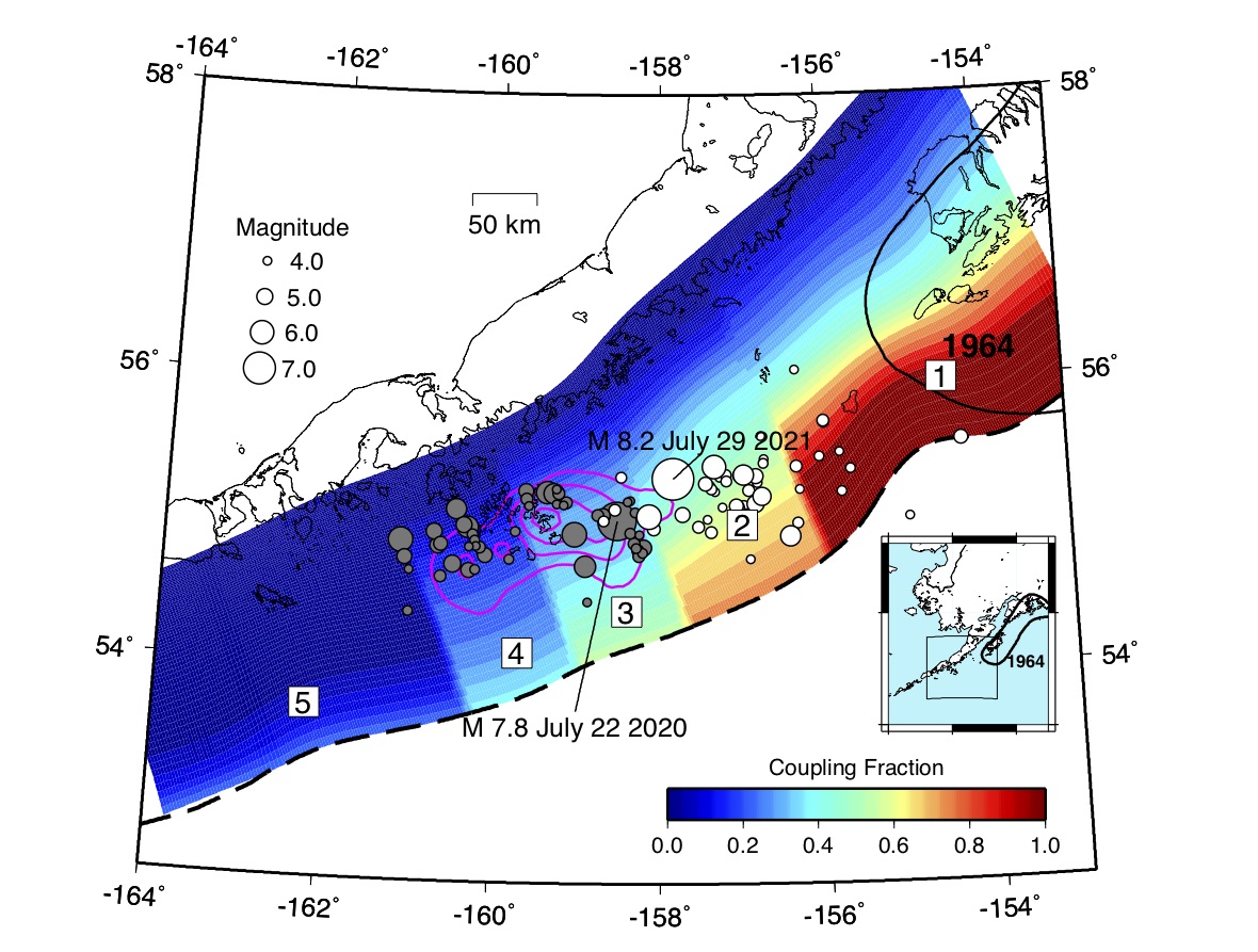
In regions that are stuck, or “highly coupled,” the upper 10 to 30 kilometers of the plate interface cannot move easily, whereas deeper sections slide continuously, resulting in a buildup of energy in the shallow part of the subduction zone. This excess energy, also called slip deficit, will be released in future, large-magnitude earthquakes. In contrast, areas that are weakly coupled are defined by a plate interface that slides along at a steady creep, with only occasional small-magnitude earthquakes. This behavior is observed westward of the Shumagin Islands, offshore of the southwest edge of the Alaska Peninsula.
The eastern portion of the subduction zone, underneath the Kodiak archipelago and Kenai Peninsula, last fully ruptured in the 1964 magnitude-9.2 Great Alaskan earthquake and has since returned to being fully locked; figure 1 shows the western end of that region. The nature of this transition from fully locked to fully creeping behavior over a span of roughly 500 kilometers along the Aleutian Trench is an area of focus for earthquake scientists.
Recent work using land-based measurements of GPS displacements suggests that the transition in coupling behavior is best explained by a series of segmented patches, each with differing degrees of coupling between the Pacific and North American plates (Figure 1). Last summer’s Simeonof earthquake appears to have occurred primarily in a segment underlying the area east of the Shumagin Islands, with broader rupture extending westward into the weakly coupled portion of the interface west of the Shumagins (Xiao et al., 2021).
In contrast, the Chignik earthquake appears to have ruptured the more strongly coupled, stickier segment westward of Chirikof Island, and the early aftershock sequence appears to have extended eastward along the subducting interface.
Is it possible that the Chignik earthquake was triggered by a redistribution of regional stress because of last summer’s Simeonof event? “Almost certainly,” says Jeff Freymueller, a geodesist at Michigan State University. “Stress redistribution caused by the July 2020 earthquake certainly brought the fault that ruptured in 2021 closer to failure,” Freymueller says. “This may be another example of clustering of large subduction earthquakes, such as we saw off the coast of Sumatra 10 to 15 years ago.”
Outstanding questions
In any case, the Chignik and Simeonof earthquakes both represent exciting new observations of earthquake slip behavior in subducting regions with partially stuck, partially slipping, characteristics. While a physical model of earthquake slip taking place along discrete fault sections known as asperities has been widely accepted for some time, scientists are only recently beginning to understand and appreciate the relationship that these asperities have on neighboring elements of the subduction system. It is also still an open question as to why events in such sequences are separated by months, or even a few years.
Given these timescales, it is difficult to say whether this sequence is over yet, and what future forms of rupture may look like. Given recurrence intervals of at least 200 years between great earthquakes like the 1964 magnitude-9.2 event, it is highly unlikely that we could see a complete rupture of the fully locked region of the fault for some time. But as we saw with last summer’s Simeonof earthquake, the redistribution of stress as a result of events like these can lead to future earthquakes months or even years into the future.
References
Bilek, S. L., & Lay, T. (2002). Tsunami earthquakes possibly widespread manifestations of frictional conditional stability. Geophysical Research Letters, 29(14), 18-1.
Davies, J., Sykes, L., House, L., & Jacob, K. (1981). Shumagin seismic gap, Alaska Peninsula: History of great earthquakes, tectonic setting, and evidence for high seismic potential. Journal of Geophysical Research: Solid Earth, 86(B5), 3821-3855.
Dixon, T. H., & Moore, J. C. (Eds.). (2007). The seismogenic zone of subduction thrust faults. New York: Columbia University Press.
Drooff, C., & Freymueller, J. T. (2021). New Constraints on Slip Deficit on the Aleutian Megathrust and Inflation at Mt. Veniaminof, Alaska From Repeat GPS Measurements. Geophysical Research Letters, 48(4), e2020GL091787.
Xiao, X. et al. (2021) The Deep Shumagin Gap Filled: Kinematic Rupture Model and Slip Budget Analysis of the 2020 Mw 7.8 Simeonof Earthquake Constrained by GNSS, Global Seismic Waveforms, and Floating InSAR Earth and Planetary Science Letters (in review)
- Venezuela’s doublet leaned toward Caracas - June 30, 2026
- Is Southern California’s Cajon Pass an ‘earthquake gate’ ready to open? - June 29, 2026
- Philippines magnitude 7.8 shock may have loaded the central Cotabato subduction zone - June 11, 2026