By Zoë Mildon, Ph.D. (University of Plymouth, UK) and Marco Meschis PhD (Birkbeck, University of London, UK).
Citation: Mildon Z., and Meschis, M. (2019), Fault responsible for the 1908 Messina earthquake identified, Temblor,http://doi.org/10.32858/temblor.028
In 1908 the town of Messina, located on the island of Sicily in Italy, was struck by a devastating Mw 7.1 earthquake. The town was badly damaged by the shaking and a tsunami and over 75,000 people were killed – making this earthquake the most deadly earthquake of the 20th century in Europe. Despite this fact, the fault responsible for this event has not been conclusively located – until now when new research has pinpointed the fault responsible.
 Figure 1 – Location map of the area, showing the active extensional faults (red lines) in Sicily and Calabria, and the levelling data used in this study (coloured dots). The Messina-Taormina fault that caused the 1908 earthquake is labelled. Adapted from Meschis et al. (2019).
Which fault generated the earthquake?
Just one year before the earthquake, levelling measurements were taken along roads around the coastline of Sicily and in the region of Reggio Calabria on the mainland. These measurements were taken by Antonio Loperfido, a civil engineer from the land register office, who was working on the engineering project aimed to the construction of the railway in southern Italy. Following the earthquake, one year later, the same locations were revisited, and new measurements were taken, which showed whether the ground had gone up or down as a result of the earthquake.

Figure 2- Comparing levelling data from 1908 Messina earthquake to datasets of other extensional faulting earthquakes in Italy and the USA. Adapted from Meschis et al. (2019).
Now geologists at Birkbeck College, UCL, University of Plymouth and Università degli Studi dell’Insubria have used this century-old data to work out which fault was responsible for producing the earthquake and tsunami. They have used existing active fault maps, compiled using field observations and bathymetric data from the Messina Straits, to build models of the potential earthquake sources. Using these models, they calculated how much the land surface should have moved up and down due to movement on the known faults and then compared this to the century-old levelling data. This dataset was also compared to other extensional faulting earthquakes around the world (Figure 2) and there are many similarities.
The new study shows that the 1908 Messina earthquake (Mw 7.1) was produced by an offshore extensional fault, inclined at 70o towards the east that moved up to 5 m (16 ft). One fault in particular, the offshore Messina-Taormina fault (Figure 1), has been identified as the most likely source of the earthquake. This is because there is good agreement between the expected surface subsidence from the fault models and the observed data.
Other scientists have previously speculated on which fault caused the 1908 earthquake, six alternative models have been suggested (Schick, 1997; Mulargia and Boschi, 1983; Bottari et al., 1986; Capuano et al., 1988; Boschi et al, 1989; Aloisi et al, 2012). However none of these proposed faults align with mapped faults on land or in the Messina Strait.
Effects of the 1908 earthquake
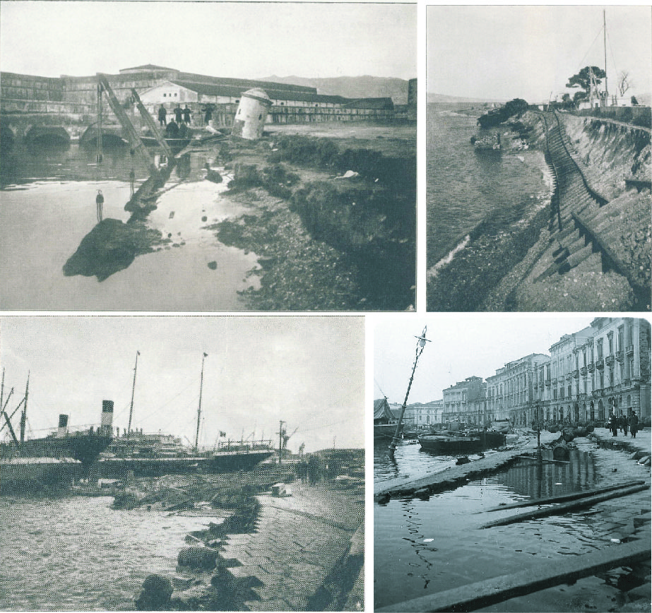
Figure 3 – Damage from the earthquake and tsunami in the city of Messina (Sicily) and Reggio Calabria (mainland)
The earthquake caused extensive damage along the coasts of both the Italian mainland and the Sicilian coastline. Both coastlines were also inundated with a 12 m (39 ft) high tsunami that struck about 10 minutes after the shaking. The city of Messina was almost levelled from the shaking and the port was badly damaged by the tsunami. The death toll was so high, partly due to the fact that the earthquake occurred during the middle of the night when many people were in the beds asleep. Up to 98% of buildings in Reggio Calabria collapsed (De Stefano, 1987). Today, most buildings are constructed following earthquake building codes, so it is unlikely that a similar earthquake today would cause as many deaths as in 1908.
The levelling dataset collected by Antonio Loperfido shows the land on the Calabrian side of the Messina Strait dropped as a result of the earthquake, with up to 58 cm (23 inches) subsidence in the city of Reggio Calabria. In Messina, the land subsided by up to 71cm (28 inches) in places, but this high subsidence is probably because of widespread landslides that occurred around the city (these data points were therefore removed from the analysis).
What about future hazard in the region?
The Messina Strait that separates Sicily from the rest of Italy is only 3 km (2 miles) wide at its narrowest point, and there are plans to build a bridge here to connect the island. If this construction project goes ahead, the bridge will be built directly across the Messina-Taormina fault. Therefore, if a future earthquake happens on this fault, this could damage the bridge and the connection of Sicily to the mainland. It is possible to build a bridge that can take account of tectonic movements from earthquakes, for example the Rion-Antirion bridge crosses the Gulf of Corinth in Greece which is getting wider at a rate of 16mm/yr (0.6 inches/yr) due to tectonic extension.
From GPS studies, it is known that the Messina Strait is opening at a rate of 2 – 3mm/yr (0.08 – 0.1 inches/yr), some of this extension will be accommodated by the Messina-Taormina fault, but the exact slip rate of the fault is not well known.
This study has shown that it is better to try and link historical earthquakes to studied and mapped active faults, and therefore to use this information when calculating the seismic hazard posed to a region. This will unavoidably impact, regionally and nationally, policy-makers for a better planning of future infrastructures lying in this region.
Acknowledgements
Thanks to Valerio Comerci for providing the photographs used in this article. Thanks to the other authors of the paper, Gerald Roberts, Jenni Robertson, Alessandro Michetti and Joanna Faure Walker.
References
Aloisi, M., Bruno, V., Cannavò, F., Ferranti, L., Mattia, M., Monaco, C., & Palano, M. (2012). Are the source models of the M 7.1 1908 Messina Straits earthquake reliable? Insights from a novel inversion and a sensitivity analysis of levelling data. Geophysical Journal International, 192(3), 1025-1041.
Boschi, E., Pantosti, D. & Valensise, G. Modello di sorgente per il terremoto di Messina del 1908 ed evoluzione recente dell’area dello Stretto. Atti VIII Convegno GNGTS, Roma 1989 (1989) 245–258 (1989)
Bottari, A., Carapezza, E., Carapezza, M., Carveni, P., Cefali, F., Giudice, E. L., & Pandolfo, C. (1986). The 1908 Messina Strait earthquake in the regional geostructural framework. Journal of geodynamics, 5(3-4), 275-302.
Capuano, B. Y. P., Natale, G. D. E., Gasparini, P., Pingue, F. & Scarpa, R. A model for the 1908 Messina Straits (Italy) earthquake by inversion of levelling data. Bulletin of the Seismological Society of America 78, 1930–1947 (1988)
Comerci, V. et al. Environmental effects of the December 28, 1908, Southern Calabria–Messina (Southern Italy) earthquake. Natural Hazards 76, 1849–1891 (2015)
De Stefano, D. (1987). I terremoti in Calabria e nel messinese. Edizioni scientifiche italiane
Loperfido, A. Livellazione geometrica di precisione eseguita dall’IGM sulla costa orientale della Sicilia, da Messina a Catania, a Gesso ed a Faro Peloro e sulla costa occidentale della Calabria da Gioia Tauro a Melito di Porto Salvo. Relazione della Commissione Reale incaricata di designare filezone più adatte per la ricostruzione degli abitati colpiti dal terremoto del 28 dicembre 1908 o da altri precedenti (1909) 131–156 (1909)
Meschis, M., Roberts, G. P., Mildon, Z. K., Robertson, J., Michetti, A. M., & Faure Walker, J. (2019). Slip on a mapped normal fault for the 28 th December 1908 Messina earthquake (Mw 7.1) in Italy. Scientific reports, 9(1), 6481.
Mulargia, F. & Boschi, E. The 1908 Messina earthquake and related seismicity. Earthquakes: observation, theory and interpretation 493–518 (1983).
Papanikolaou, I. D., Foumelis, M., Parcharidis, I., Lekkas, E. L., & Fountoulis, I. G. (2010). Deformation pattern of the 6 and 7 April 2009, MW= 6.3 and MW= 5.6 earthquakes in L’Aquila (Central Italy) revealed by ground and space based observations. Natural Hazards and Earth System Sciences, 10(1), 73.
Schick, R. Eine seismotektonische Bearbeitung des Erdbebens von Messina-im Jahre 1908. Geologisches Jahrbuch Reihe E, Band E 11 (1977).
Societa` Fotografica Italiana (1909) Messina e Reggio prima e dopo il terremoto del 28 dicembre 1908. Firenze, 437 p
Stein, R. S., & Barrientos, S. E. (1985). Planar high‐angle faulting in the Basin and Range: Geodetic analysis of the 1983 Borah Peak, Idaho, earthquake. Journal of Geophysical Research: Solid Earth, 90(B13), 11355-11366.
- Identificata la faglia responsabile del terremoto di Messina del 1908 - June 24, 2019
- Fault responsible for the 1908 Messina earthquake identified - June 12, 2019