By David Jacobson and Ross Stein, Temblor

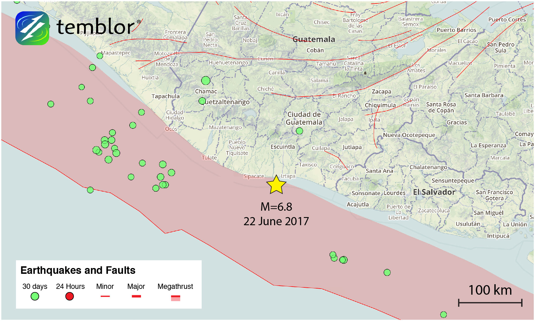
At 6:31 a.m. local time, a M=6.8 earthquake struck offshore of Guatemala, and was widely felt throughout the country and in neighboring El Salvador and Mexico. According to the Associated Press, initial reports suggest only minor damage, as local media showed images of small cracks in old buildings and damage to adobe-walled homes. However, however the National Reduction Center of Guatemala (CONRED; 2017) reports medium damage in the Sacatepéquez, Totonicapán and Suchitepéquez Departments, mostly in roads, buildings and bridges. Based on the USGS ShakeMap, this earthquake was large enough to generate strong shaking along the coastline, and light shaking in Guatemala City, the country’s capital, home to 3.3 million people. According to the USGS PAGER system, both fatalities and economic losses are estimated to be low.
This is the second large magnitude earthquake to strike Guatemala in the last eight days. While the M=6.9 on June 14 was inland, and occurred at a depth of 94 km (according to the USGS), today’s M=6.8 had an epicenter approximately 17 km offshore of Guatemala’s southern coast, and struck at a depth of 47 km. To read about last week’s Guatemala earthquake, click here. Are these events related? They are far enough apart that there are no static stress effects. Delayed dynamic stressing by the seismic waves of the June 14 shock is possible, but very difficult to prove.
Because of this active margin, today’s earthquake should come as no surprise. Additionally, through examining the historical seismicity of this area offshore of Guatemala, which is shown below, it can be seen that M=6+ earthquakes are very common near the Central American coastline. Most notable in this area is a M=6.8 earthquake in 1979 just 10 km to the northeast of today’s quake. This event also occurred on the subducting slab, generated very strong shaking, and resulted in seven deaths in Guatemala. Additionally, in 1942, this entire area ruptured in a M=7.7 earthquake that killed 38 people, and generated thousands of landslides, which were aided by heavy seasonal rain.

In addition to the regular offshore seismicity shown in the map above, the Global Earthquake Model’s Global Historical Earthquake Archive shows seismicity dating back to the 1500’s. The figure below highlights how there is a band of large magnitude earthquakes that follow the volcanic arc through Central America.

By looking at the Global Earthquake Activity Rate (GEAR) model, which is available in Temblor, we get additional evidence that today’s earthquake should not be considered surprising. This model, which uses global strain rates and seismicity since 1977, estimates the likely earthquake magnitude in your lifetime anywhere on earth. In the Temblor map below, one can see that today’s earthquake struck in an area that is susceptible to M=7.5 earthquakes. While a M=7.5 does not seem that much larger than a M=6.8, a M=7.5 actually releases 11 times more energy. If such an event were to occur off the coast of Guatemala, the effects could be devastating. The last time an earthquake of this magnitude struck this part of Central America was in 2012, when a M=7.4 quake stuck 110 km to the northwest of today’s event, killing 39 people, damaged thousands of buildings, and generated countless landslides, which are a primary hazard associated with Guatemalan earthquakes. So, event though today’s earthquake may not have caused significant damage, a much larger event could occur, and residents should be aware of the significant seismic hazard in the region.

References
USGS
Paola Albini et al., 2013, Global Historical Earthquake Archive, Global Earthquake Model (GEM), GEM Foundation
Luis Edgar Rodríguez Abreu
- Earthquake science illuminates landslide behavior - June 13, 2025
- Destruction and Transformation: Lessons learned from the 2015 Gorkha, Nepal, earthquake - April 25, 2025
- Knock, knock, knocking on your door – the Julian earthquake in southern California issues reminder to be prepared - April 24, 2025