By David Jacobson, Temblor
Click here to read more about continuing seismicity around Guatemala
Click here for Spanish version
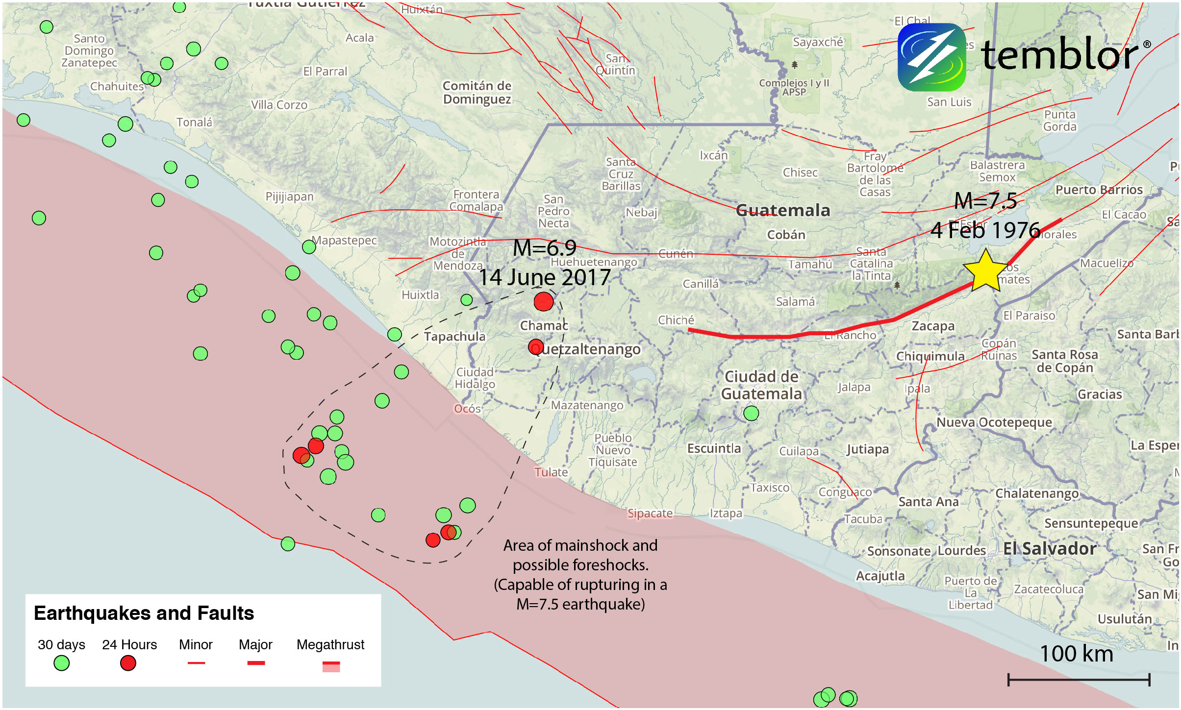
At 1:29 a.m. local time, a M=6.9 earthquake struck western Guatemala near the border with Mexico. Despite the quake’s deep depth (94 km according to the USGS) it was widely felt throughout Central America, including in Guatemala City 160 km away, which is home to 3.3 million people. According to officials in Guatemala, landslides were triggered, blocking highways, and houses were moderately damaged. Fortunately, the region around the epicenter, which, based on the USGS ShakeMap experienced strong shaking, is mountainous and sparsely populated and there is only one known injury. Across the border in Mexico, minor damage was also sustained.
This part of Central America is highly seismically active due to a combination of relative plate motions. Off the southern coast, the Cocos Plate is subducting beneath both the North American and Caribbean plates. Additionally, left-lateral strike slip motion is also present in much of eastern and central Guatemala due to the active plate boundary between the North American and Caribbean plates. This means that Guatemala sits on what is known as a triple junction, where three tectonic plates meet.
As a result, this region has experienced large, damaging earthquakes, including a M=7.5 earthquake in 1976 in eastern Guatemala that killed nearly 23,000 people and left more than 75,000 injured (Olcese et al., 1977). That devastating quake occurred at a depth of 5 km, and was on the Motagua Fault, which is a pure left-lateral strike-slip fault. In comparison, today’s quake was almost purely extensional and occurred at the much greater depth of 94 km (according to the USGS). While the location and depth of the earthquake suggests that the rupture occurred near the subducting slab, its extensional nature indicates that it may have been caused by localized steepening of the slab. This idea is further supported as in 2009, there was a M=6.3 at a similar depth that also occurred on an extensional fault.
While today’s earthquake and the deadly one in 1976 were vastly different in their nature and impact on the region, they highlight an important earthquake characteristic: depth. Even had today’s earthquake been a M=7.5, like the one in 1976, it would not have caused as much damage, because it occurred at a depth 19 times greater. This is because significant energy is lost, resulting in less shaking at the surface. In the side-by-side figures below, USGS ShakeMaps are shown for today’s earthquake, and the one in 1976. From these, one can see that while violent shaking was felt in the 1976 quake, today’s shaking only reached strong levels.

Another aspect of this quake which deserves extra attention is that in the nine hours prior to the M=6.9 mainshock, there were five smaller magnitude earthquakes, ranging from M=4.4 to M=5.6, just offshore. Two of these occurred within an hour of the M=6.9, including one just 6 minutes prior. While not necessarily indicative of foreshock events, given they were over 100 km away, the rate at which they occurred is substantially higher than the normal background rate. Therefore, if they were foreshocks, they could indicate that a larger creep event took place at the Middle America Trench. While creep events do not necessarily precede large earthquakes, if this area along the subduction zone were to rupture, a M+7.5 earthquake could result. This would generate severe shaking along the Central American coastline, and could trigger a tsunami. Therefore, these smaller events that preceded the mainshock deserve attention.
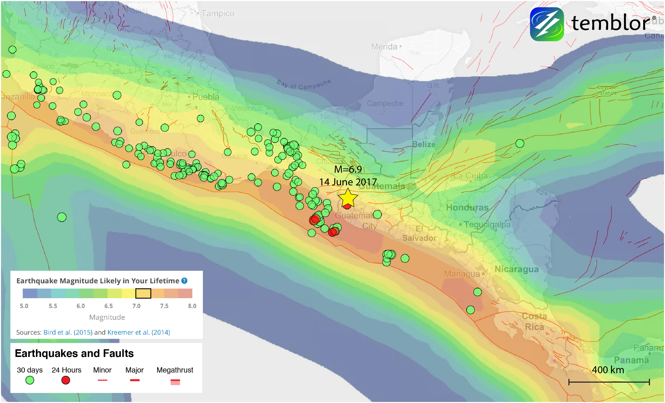
Because of the complex tectonic environment on which Honduras, and the rest of Central America sits, large earthquakes should be expected. Using the Global Earthquake Activity Rate (GEAR) model, which is available in Temblor, we can see what the likely earthquake magnitude in your lifetime is anywhere on earth. While today’s quake is deeper than GEAR takes into account, we can still see in the map below that for much of central, western, and southern Guatemala, M=6.75+ earthquakes should be expected. Because of this, residents of the small country should be prepared for, and understand the regional earthquake hazards.
References
USGS
Mexican Seismological Service (SSN)
European-Mediterranean Seismological Centre
Associated Press
A. F. Espinosa, The Guatemalan earthquake of February 4, 1976, a preliminary report, Professional Paper 1002, 1976
Luis Edgar Rodríguez Abreu
- Earthquake science illuminates landslide behavior - June 13, 2025
- Destruction and Transformation: Lessons learned from the 2015 Gorkha, Nepal, earthquake - April 25, 2025
- Knock, knock, knocking on your door – the Julian earthquake in southern California issues reminder to be prepared - April 24, 2025