By David Jacobson, Temblor

Last Monday, we posted a blog about a landslide in Greenland that triggered a fatal tsunami in Greenland. Initially, based on seismic signals, it appeared as if a M=4.1 earthquake caused the slide. However, in the aftermath of the event, scientists have examined the event more carefully, and have now determined that there was no earthquake. Instead, the landslide was so large that it generated significant seismic energy. Because of this new data, we thought we’d provide the most updated information, courtesy of IRIS and AGU blogs, which drew findings from scientists all over the world.
This video link shows the moment the tsunami struck the small village of Nuugaatsiaq. Technically, this event was what is known as a seiche, which, according to NOAA is a “standing wave oscillating in a body of water.” These waves can be caused by a temporary disturbance in a lake or partially enclosed body of water.
Two clues that led scientists to see that there had in fact been no earthquake were the duration and characteristic of the seismic signals. Not only did the seismic waves last for approximately five minutes, but they were monochromatic and slowly increased in amplitude (the highest amplitude waves lasted about 30 seconds). Such traits, according to the IRIS blog, authored by John Clinton (ETH Zurich), Tine Larsen, Trine Dahl-Jensen, Peter Voss (GEUS Copenhagen), and Meredith Nettles (Lamont-Doherty Earth Observatory at Columbia University) are “indicative of complex landslide signals.”
The figure below shows two time series from a seismic station in Greenland. The first shows a period of about 20 minutes. At the start of the signal, the high amplitude waves from the landslide are clearly visible. Then, approximately seven minutes after the start of the slide there are longer period waves, which represented the water waves pounding on the shoreline. These water waves were able to influence the seismic signal because the ground tilted due to changing sea levels. In the second time series, the first few minutes of the slide are highlighted. This clearly shows an increasing amplitude, and a duration of approximately 30 seconds for the highest amplitude waves.

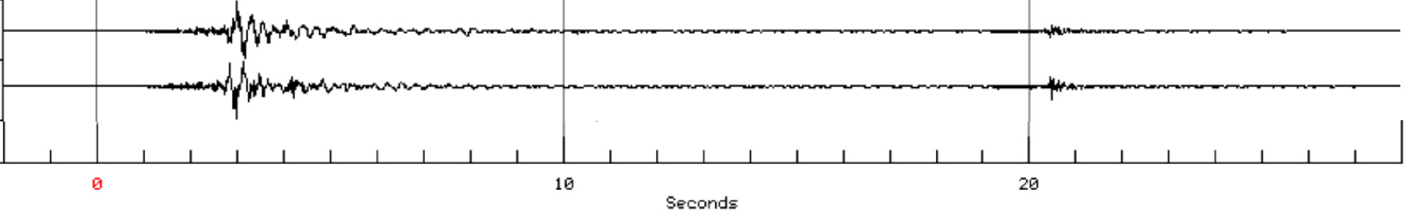
While these seismic signals may look like an EKG, they allow scientists to tease out what happened. First, it is important to remember that initially, scientists believed that a M=4.1 quake triggered the landslide. In the figure below, the seismic signal for 30 seconds in a M=4.0 earthquake in California is shown. What is most important to point out is that the highest amplitude waves only lasted for about a second. Compare this to the Greenland slide, which generated high amplitude waves for 30 seconds, and seismic energy for a total of five minutes.
Such an important discovery also leads to another question, what caused the landslide? Frist, based on before and after imagery obtained and analyzed by researchers at Strasbourg University, they determined that the area may have been active prior to the major slip event. This means is that the area was likely already unstable prior to the major movement. The researchers determined this by observing landslide deposits prior to the June 17th event. This, they also say reduces, but does not eliminate, the risk of imminent failure. However, this still does not explain why this recent landslide happened. At this time, we can only hypothesize. One possible explanation is that seasonal increases in temperature resulted in melting of ice, which destabilized the area. As more information continues to come in, we will update this post.
References
IRIS Blog titled “Special Event: Nuugaatsiaq Greenland landslide and tsunami” – Link
AGU Blog titled “Much more detail about the Greenland landslide and tsunami, including images and video” by David Petley – Link
- Earthquake science illuminates landslide behavior - June 13, 2025
- Destruction and Transformation: Lessons learned from the 2015 Gorkha, Nepal, earthquake - April 25, 2025
- Knock, knock, knocking on your door – the Julian earthquake in southern California issues reminder to be prepared - April 24, 2025