By David Jacobson, Temblor

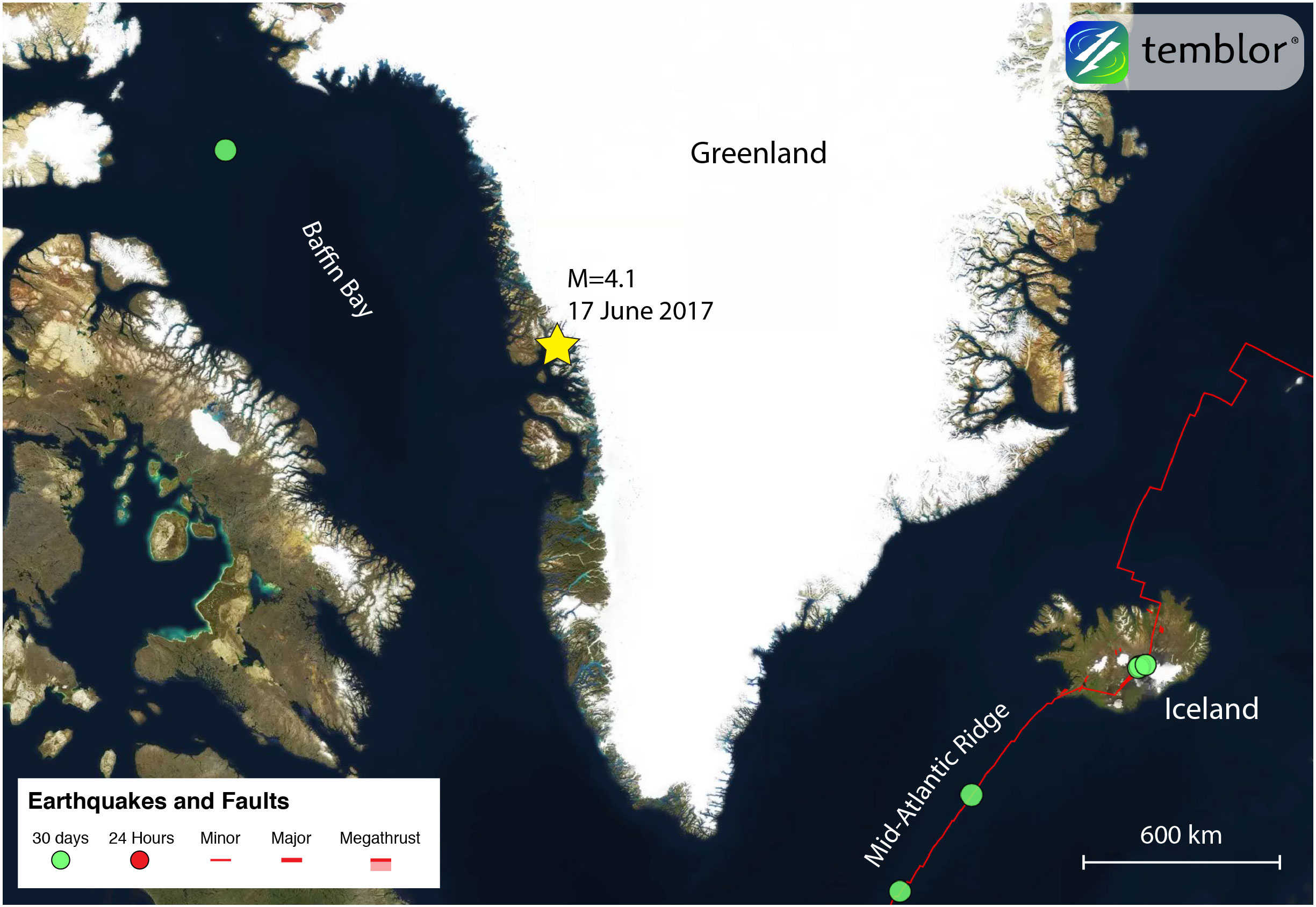
Over the weekend, a M=4.1 earthquake on Greenland’s western coast caused a massive landslide, triggering a tsunami that inundated small settlements on the coast. At this stage, four people are feared to have died, nine others were injured, and 11 buildings were destroyed. In the hardest hit village, Nuugaatsiag, which is home to around 100 people, 40 people have been evacuated to Uummannaq, the eleventh-largest town in Greenland (see picture below).
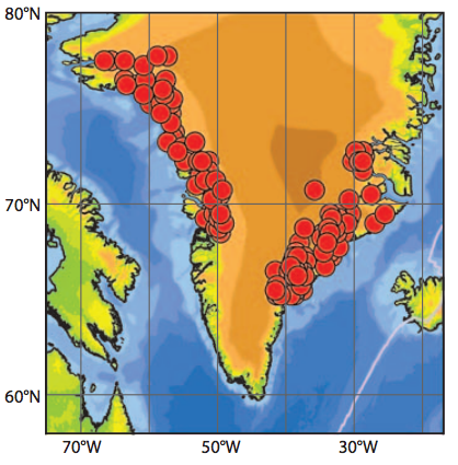
While this earthquake appears to be tectonic in nature, according to Professor Meredith Nettles of the Lamont-Doherty Earth Observatory at Columbia University, Greenland also experiences what are known as glacial earthquakes. Glacial earthquakes are a relatively new class of seismic event, and are often linked to the calving of large outlet glaciers. While this type of event has also been observed in Antarctica, the majority have been recorded off the coast of Greenland, and show a strong seasonality, with most of them occurring late in the summer.

Because glacial earthquakes have a different mechanism than normal earthquakes, standard earthquake monitoring techniques cannot be used to detect them, which explains why they were not known about until 2003. Additionally, while a tectonic M=5 quake typically lasts about 2 seconds, a comparable M=5 glacial earthquake can emit long-period (great than 30 seconds) seismic waves. It is because of this, that they have a separate classification.
In order for a glacial earthquake to occur, a large-scale calving event has to take place. When a glacier calves, there is both a sudden change in glacial mass and motion. While a glacier is technically a river of ice, meaning it slowly flows downhill, when a large calving event take place, there is a brief period when horizontal motion reverses. Couple this with a downward deflection of the glaciers terminus, which causes a upward force on earth’s surface, and you have the recipe for a glacial earthquake. These earthquakes tend to be M=4.6-5.1.
algorithm.
Despite the fact that this tectonic quake was by no means large, it was big enough to trigger a massive landslide into the ocean, and the ensuing displacement of water was enough to form a tsunami that devastated parts of Nuugaatsiag. Prof. Nettles said to us, “The M=4.1 earthquake does not explain the large, long-period (slow) seismic signal detected by seismometers around the globe. The long-period signal appears to be due to a landslide, and the time of the long-period signal is later than the time of the high-frequency (earthquake) signal. It is possible the earthquake triggered the landslide.” What this means is that both the earthquake and landslide generated seismic signals, but that the earthquake signal appeared first, suggesting the quake triggered the slide. The video below shows a view of the landslide, while the photos show the landslide and the devastation caused by the tsunami. In response to this event, and the risk of aftershocks, people have been advised to stay away from the coastline.
The video below shows a helicopter video of the landslide that triggered the deadly tsunami in Greenland


References
Geological Survey of Denmark and Greenland (GEUS)
Meredith Nettles and Goran Ekstrom, Glacial Earthquakes in Greenland and Antarctica, Annu. Rev. Earth Planet. Sci. 2010. 38:467–91, doi: 10.1146/annurev-earth-040809-152414
T. Murray, M. Nettles, N. Selmes, L. M. Cathles, J. C. Burton, T. D. James, S. Edwards, I. Martin, T. O’Farrell, R. Aspey, I. Rutt, T. Baugé, Reverse glacier motion during iceberg calving and the cause of glacial earthquakes, sciencemag.org/content/early/recent / 25 June 2015 / Page 1 / 10.1126/science.aab0460
2015 Washington Post article by Chris Mooney titled “Giant earthquakes are shaking Greenland — and scientists just figured out the disturbing reason why” – Link
2015 NPR article titled “Study Reveals What Happens During A ‘Glacial Earthquake” – Link
- Earthquake science illuminates landslide behavior - June 13, 2025
- Destruction and Transformation: Lessons learned from the 2015 Gorkha, Nepal, earthquake - April 25, 2025
- Knock, knock, knocking on your door – the Julian earthquake in southern California issues reminder to be prepared - April 24, 2025