by Abdul Muhari (Ministry of Marine Affairs and Fisheries, Indonesia), Fumihiko Imamura (International Research Institute of Disaster Sciences IRIDeS, Tohoku University, Japan), Taro Arikawa (Chuo University, Japan), and Bagus Afriyanto (Ministry of Marine Affairs and Fisheries, Indonesia)
1. Introduction
A strike-slip fault earthquake where epicenter located at the north part of Donggala District, Central Sulawesi, Indonesia suddenly triggering the tsunami with the reported water level up to 8m inside Palu Bay, about 50 km to the south-east of epicenter. There are also observations of tsunami waves with run-up elevations of about 2 – 6 meters reported from the survivors at the damaged area, which should be limited to understand what the tsunami characteristics is at this event. Therefore, a rapid post-tsunami survey was conducted from 4-6 October 2018 requested by the Ministry of Marine Affairs and Fisheries, Indonesia to understand characteristic and damages caused by tsunami and to find indications of possible tsunami generation aside of earthquake. The survey is aimed to obtain tsunami characteristics such as tsunami height, flow depth, inundation distance, damage characteristics and eyewitnesses account, which result should contribute the planning of reconstruction at the damaged area. In this preliminary survey we have the limitation of time and road condition to visit the coastal area inside of Palu bay which the tsunami would mostly affect after the earthquake. The survey points are shown in Fig.1. with the tsunami heights of splash wave (red color) and flow depth (blue color) measured in Palu bay.

2. Field Survey Data/Information at Talise beach
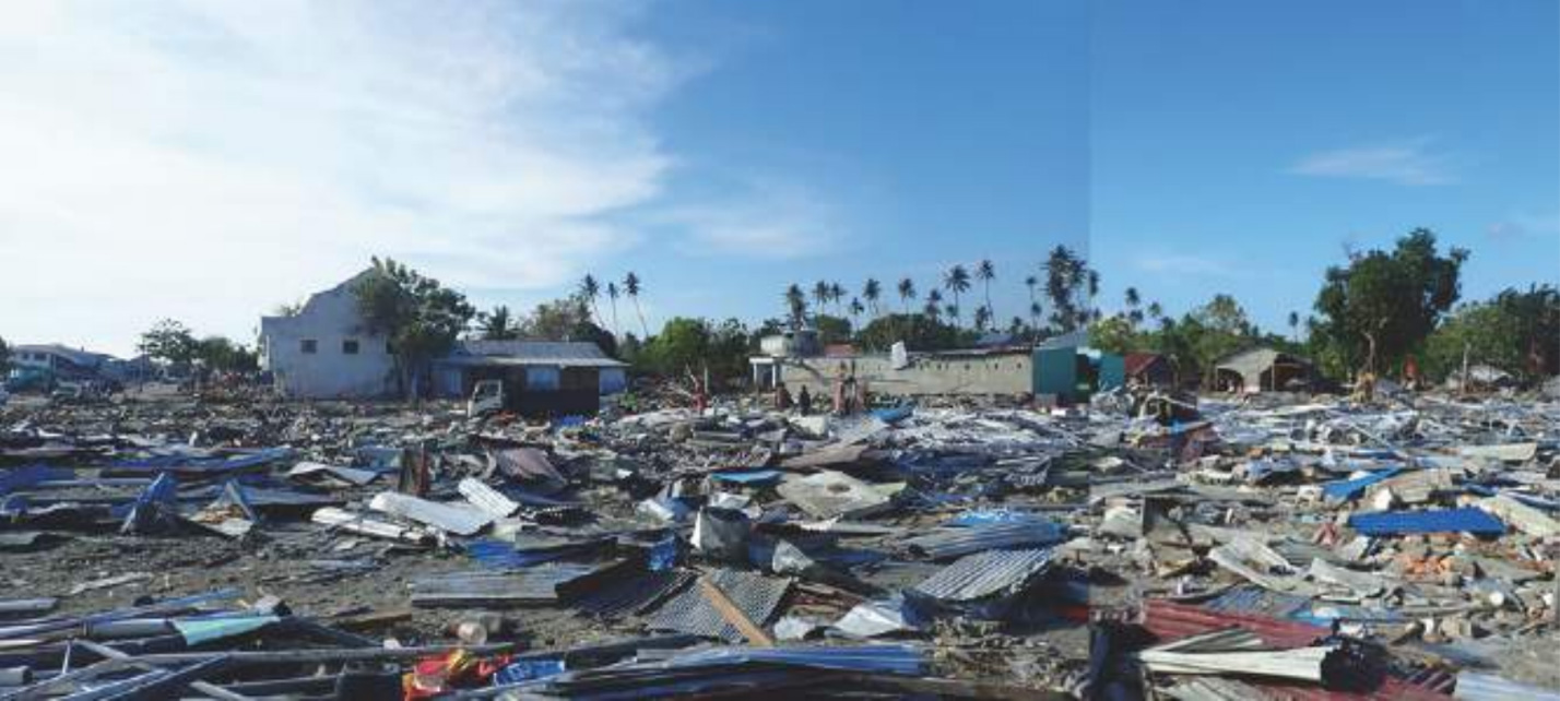
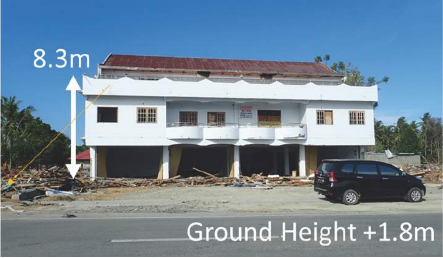
A team consists of four scientists from Indonesia and Japan conducted measurement at Talise beach located at the endmost of the bay and in the area on the east side of the bay. The damage condition along the coast we observed a week after the earthquake and tsunami are shown in Photo 1-3. Along the Talise Beach, the tsunami trace at a distance up to 50 m from the coastline is found at a depth of splash wave of about 7-8 m from the ground level and about 9-10m from the sea level as stated by the two eyewitnesses as shown in Photo 4. Further inland, inundation depths were found in average of 1m as shown as trace of water at the wall inside the house, but splash wave marks outside the house were found up to 3.5 m from the ground. The inundation distance reached up to 300 m inland, but the damages are concentrated only in the area located less than 200m from the coastline. The summary of the tsunami characteristic obtained from the field survey is shown in Fig.2.


3. Field Survey Data/Information in the east coast of Palu bay
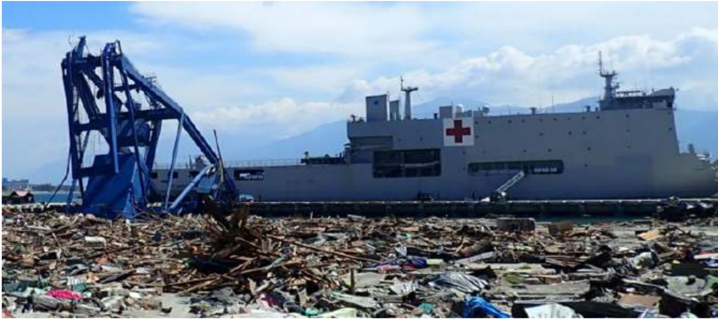
At Pantoloan along the east side of the bay, the large vessel with about 50m long was landed where the inundation depth was measured to be around 2 m and ground height was 2.3m, so that inundation height was about 4 m. But the inundation stopped 180 m from the coast, suggesting the length of this tsunami seems to be short. About tsunami behavior, the residence said that tsunami arrived in a few minutes after the earthquake motion. Along the east side of the bay, at Pantoloan the large vessel with about 50 m long was landed shown in Photo 5. Here, then inundation depth was around 1.9 m and ground height was 2.3m, so that inundation height was about 4.2 m. But the inundation stopped 180m from the coast. That means the length of this tsunami seems to be short. About tsunami behavior, the residence said that tsunami arrived in a few minutes after the earthquake motion.

The port in Pantoloan, there were also many containers and small ships. The inundation height was 4.9m. The gantry crane was fallen because the foundation part had disappeared as shown in Photo 6. And the residence said that tsunami was coming from west north side.
At Mamboro, there was more serious damage as shown in Photo 7. The inundation depth was around 4.5m and the ground height was around 2.0m. And the maximum splash height was 10.1m above the sea level. Photo 8 shows the house located nearby sea, which had some evidence of the splash. It indicated that the inundation flow speed seems to be relative high like bore.
4. Summary
Based on the described available data/information, we can summarize that the tsunami in Palu bay has a relatively short period of wave as observed at Pantoloan port. It was rapidly arrived onshore and creates huge impact at the distance of 50 m from the coastline where the maximum flow depth reaches up to 8 m. This flow depth is rapidly decreased when it passing through dense population into average of 1m flow depth inside the house located at the distance about 150m from the shoreline. The above-mentioned findings suggested that tsunami might be generated by mechanism other than the strike-slip earthquake, where this suspected source should be located nearby the impacted areas with relatively narrow width of source geometry. Since the tsunami might be generated at the shallow water, the resulting tsunami might have been amplified near the coastline and become splash wave. It is damaging the structures nearby the shore but it has no sufficient energy to penetrate further inland.
5. References
Abdul Muhari, Fumihiko Imamura, Taro Arikawa, Aradea R. Hakim and Bagus Afriyanto, Solving the puzzle of September 2018 Palu, Indonesia tsunami mystery: clues from recorded tsunami waveform and the initial field survey data inside the bay, Journal of Disaster Research, Submitted, 2018.
Jason R. Patton, Ph.D., Shinji Toda, Ph.D., Ross Stein, Ph.D., Volkan Sevilgen, M.Sc.,The Palu-Koro fault ruptures in a M=7.5 quake in Sulawesi, Indonesia, triggering a tsunami and likely more shocks,temblor.net http://temblor.net/earthquake-insights/the-palu-koro-fault-ruptures-in-a-m7 -5-quake-in-sulawesi-indonesia-triggering-a-tsunami-and-likely-more-shock s-7797/
- Beware quiet segments of the Philippine Fault - May 16, 2025
-
ډیری عوامل افغاني ټولنې د زلزلې پر وړاندې زیانمنوي
- August 11, 2022 - What’s happening this week in Humboldt County, California: The squeeze - February 6, 2019