Surveys reveal how different stakeholders used aftershock forecasts following the 2016 Kaikōura earthquake in New Zealand.
By D’Maia Curry, freelance science writer
Citation: Curry, D., 2020, How do people use aftershock forecasts? The survey says…, Temblor, http://doi.org/10.32858/temblor.127
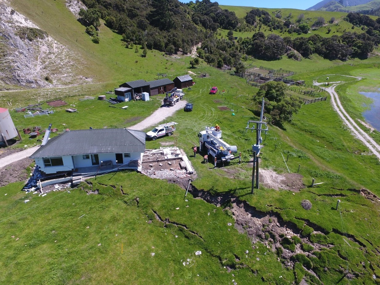
On Nov. 14, 2016, a magnitude-7.8 earthquake struck near Kaikōura, New Zealand, causing strong shaking and structural damage in the lower North and Upper South Islands. Following the earthquake, aftershock forecasts were produced by scientists and communicated to agencies and the public, forecasting the likelihood of aftershock occurrence. In a new study, researchers examined how agency decisionmakers and the general public used and interpreted aftershock forecasts after the Kaikōura earthquake. Their results suggest that while the public generally uses aftershock forecasts in their earthquake hazard decisions, communication of forecasts can always be improved.
Forecasting aftershocks
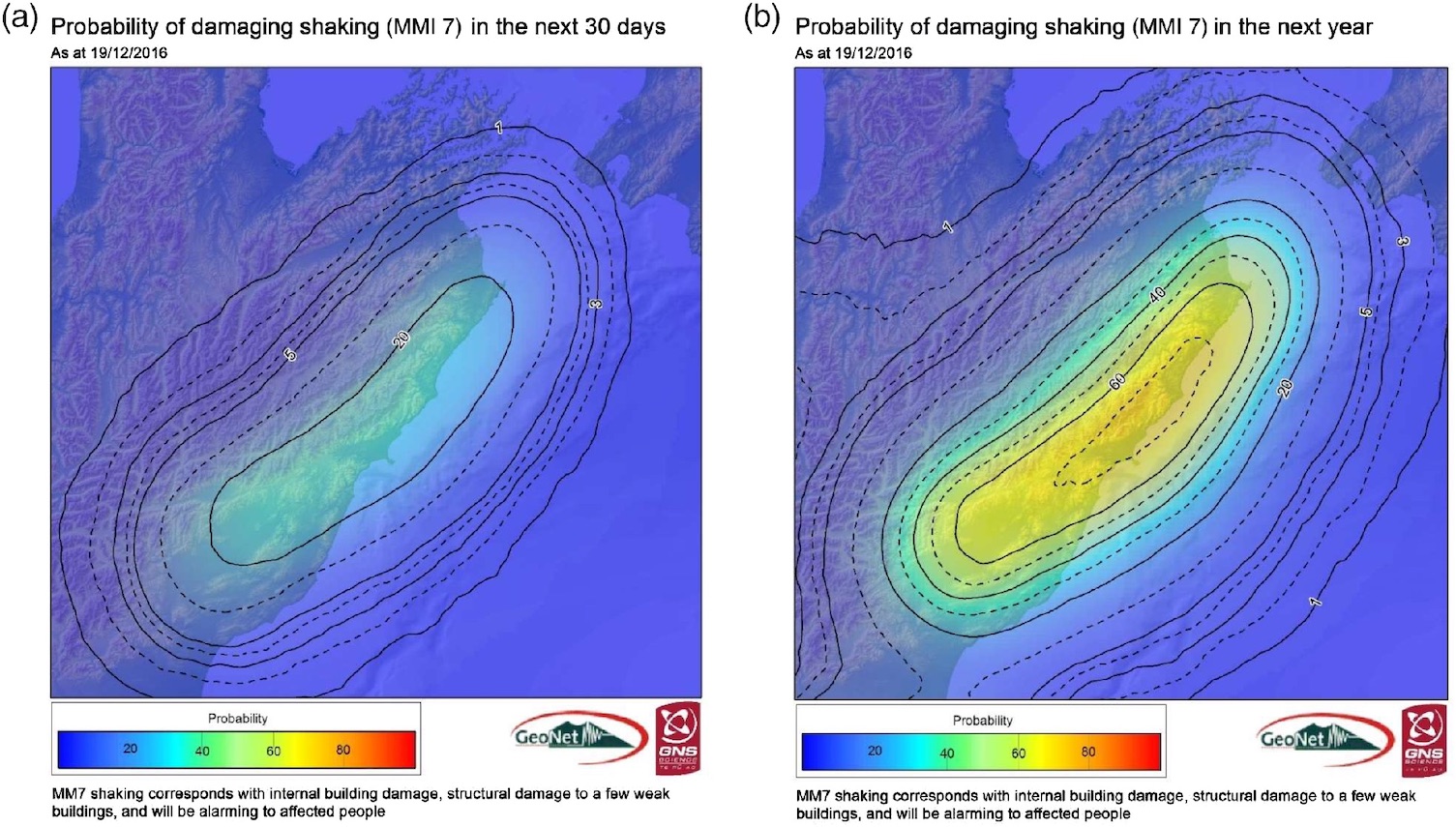
Aftershock forecasts are a tool that scientists use to communicate aftershock forecasts to the public. These forecasts are time-dependent probabilities of future earthquake risk and hazard and have been released by scientific organizations in the United States, New Zealand and Japan since the late 1970s. Aftershock forecasts provide an “expectation of the quantity and intensity of earthquakes people can expect in a certain time period of interest, such as a day, a month, or a decade,” says Anne Wein, an operations research analyst at the U.S. Geological Survey, who was not involved in the new research. Aftershock forecasts are important, Wein says, as “they can influence personal decisions on earthquake preparation and inform decisions to reduce seismic exposure in both response (crisis) and long-term planning situations.” Following the magnitude-6.2 Christchurch earthquake in 2011, Wein saw these aftershock forecasts being used for future building standards and land-use policy changes. Thus, she says, it is important that these forecasts are communicated clearly so that people can prepare for aftershocks and so that policies are developed to mitigate earthquake hazard and risk.
How aftershock forecasts are used
Following the 2016 Kaikōura quake, social scientist Julia Becker of GNS Science and Massey University in New Zealand and her colleagues in disaster communications research wanted to understand how people use aftershock earthquake forecasts. About a month after the mainshock, the researchers surveyed scientists, technicians and support staff at GNS Science and various other agencies, including emergency managers, planners and responders. The surveys, consisting of 12 quantitative tick-box and qualitative free-response questions, were used to understand how people in varying positions and with varying degrees of expertise understood the forecasts and how they used them in their daily lives.
Survey questions included where the participants lived and worked, their perception of current earthquake probability, their use of aftershock forecasts for decision-making and what they think the best way to find or receive aftershock forecasts is.
Survey says…
The surveys revealed that the majority of participants had seen aftershock forecasts following the November earthquake, Becker and her colleagues reported in Seismological Research Letters. Many survey participants also used aftershock forecasts for decision-making purposes, such as thinking about securing the foundation in their houses, securing furniture to their walls and having more conversations around earthquake preparedness. “We found that people were a lot more engaged with forecasts than we thought,” Becker says.

However, the surveys revealed challenges with aftershock forecast communication, the team reported. One major challenge was that survey participants from more technically versed agencies were more comfortable with understanding the complexities of aftershock forecasts while less-technical agencies and members of the general public often struggled. This finding is consistent with previous studies that concluded that a diversity of basic and technical aftershock forecast information, provided via various mediums, is needed to suit users’ diverse backgrounds and technical needs (Wein et al., 2016, and Becker et al., 2019). Another aftershock forecast communication challenge was that many stakeholders were uncertain about how to apply aftershock forecast information to decisions made during emergency response and recovery. To overcome these challenges, the authors suggest that scientists identify and work in partnerships with communities to develop aftershock forecast communications that will best serve a particular community or audience. They also recommend future aftershock forecast communication materials include explicit recommendations for specific actions to take to reduce risk. One route is to increase a social media presence for science agencies, so questions about the forecasts can be answered quickly online by the earthquake scientists themselves, as was explored in the Bombay Beach swarm in 2016 (McBride et al., 2020).
Better forecast communications
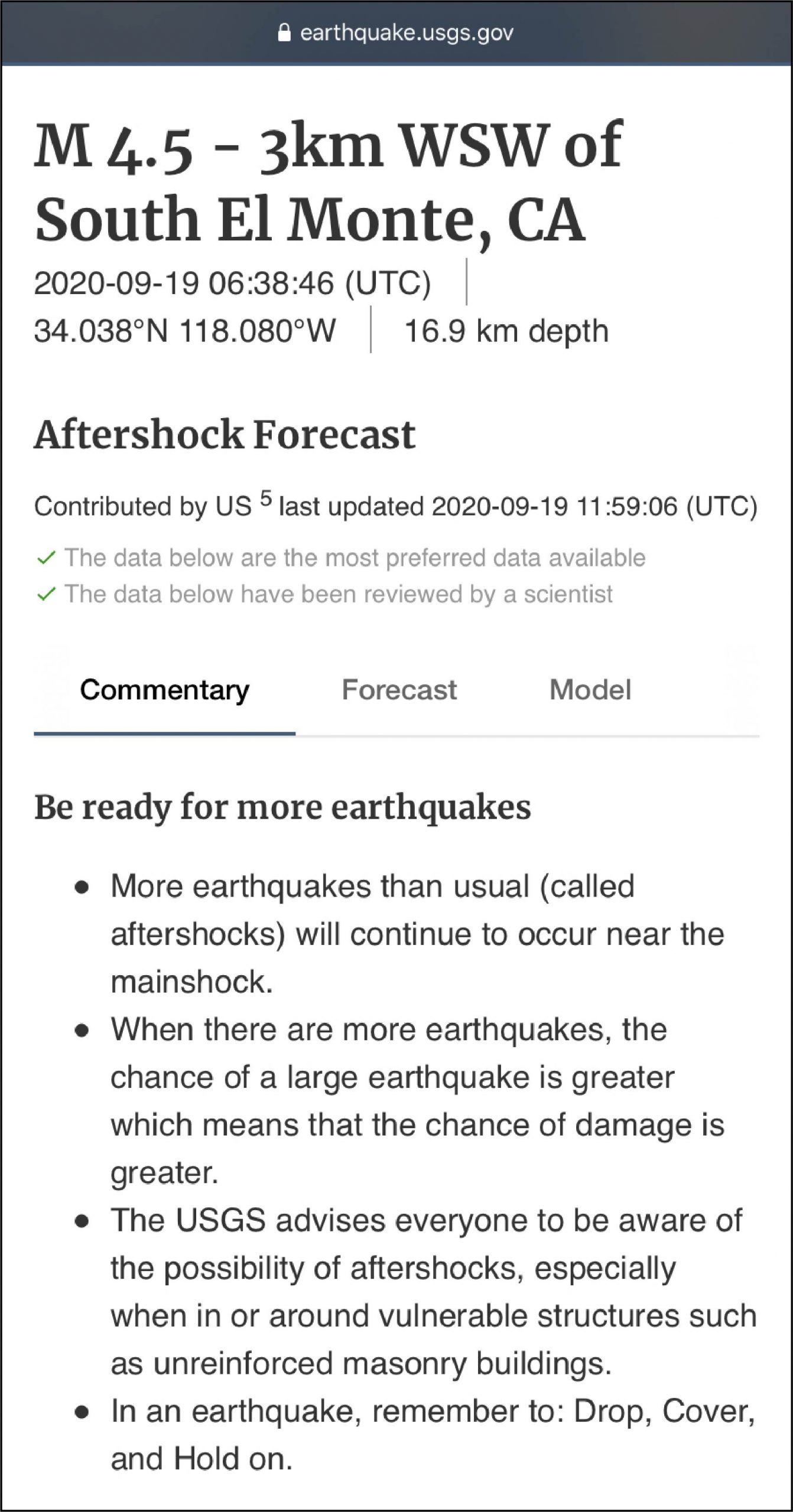
This research has implications for how future forecasts are communicated, Wein says. Using the lessons learned and insights gained from these surveys, scientists have already made changes to their aftershock forecast communications for quakes in Alaska in 2018 (Michael et al., 2019), California in 2019, and Puerto Rico in 2020. The USGS is currently the only government agency that communicates aftershock forecasts on a regular basis, says Sara McBride of USGS, a co-author of the current study. USGS’s thresholds for release of a forecast are magnitude 5 or above for earthquakes in the United States. Currently, they only release a forecast in the U.S. and associated territories, she adds.
This research has even informed the communication of forecasts for other natural hazards, notably the 2019 Whakaari White Island volcanic eruption. A lot of progress has been made when it comes to trying to understand and talk about forecasts, Becker notes. But, as the authors of the paper describe, it is important that organizations and agencies continue exploring ways to communicate forecasts more effectively.
Further Reading
Becker, J. S., Potter, S. H., McBride, S. K., Doyle, E. E., Gerstenberger, M. C., & Christophersen, A. (2020). Forecasting for a Fractured Land: A Case Study of the Communication and Use of Aftershock Forecasts from the 2016 Mw 7.8 Kaikōura Earthquake in Aotearoa New Zealand. Seismological Research Letters. https://doi.org/10.1785/0220190354.
Becker, J.S., Potter, S. H., McBride, S. K., Wein, A., Doyle, E. E. H., & Paton, D. (2019). When the earth doesn’t stop shaking: How experiences over time influenced information needs, communication, and interpretation of aftershock information during the Canterbury Earthquake Sequence, New Zealand. international Journal of Disaster Risk Reduction. https://doi.org/10.1016/j.ijdrr.2018.12.009
McBride, S. K., Llenos, A. L., Page, M. T., & van der Elst, N. (2019). #EarthquakeAdvisory: Exploring discourse between government officials, news media, and social media during the 2016 Bombay Beach Swarm. Seismological Research Letters. https://doi.org/10.1785/0220190082
Michael, A. J., McBride, S. K., Hardebeck, J. L., Barall, M., Martinez, E., Page, M. T., van der Elst, N., Field, E. H., Milner, K. R., Wein, A. M. (2019). Statistical Seismology and Communication of the USGS Operational Aftershock Forecasts for the 30 November 2018 Mw 7.1 Anchorage, Alaska, Earthquake. Seismological Research Letters. https://doi.org/10.1785/0220190196
Wein, A., Potter, S., Johal, S., Doyle, E., & Becker, J. S. (2016). Communicating with the public during an earthquake sequence: Improving communication of geoscience by coordinating roles. Seismological Research Letters. https://doi.org/10.1785/0220150113
- Destruction and Transformation: Lessons learned from the 2015 Gorkha, Nepal, earthquake - April 25, 2025
- Knock, knock, knocking on your door – the Julian earthquake in southern California issues reminder to be prepared - April 24, 2025
- A magnitude 6.2 quake strikes the Marmara Fault at site of large historic earthquakes near Istanbul - April 23, 2025