Friday’s coverage of the American Geophysical Union (AGU) 2020 Fall Meeting focuses on preparing for cascading hazards, searching for unusual subduction zone earthquakes and helping illuminate earthquake hazard in Haiti.
By Megan Sever, science writer and editor (@megansever4)
Citation: Sever, M., 2020, Dispatches from AGU, Temblor, http://doi.org/10.32858/temblor.145
The Fall Meeting of the American Geophysical Union (AGU) may not look much like normal this year — especially since I’m writing this from my home office in Portland, Oregon, rather than the media room in the Moscone Center. But that doesn’t mean there aren’t tons of exceptional research findings being presented. Today, Friday, Dec. 11, I found dozens of posters and talks I wanted to explore. Below, you’ll find a few highlighted, in case you missed them.
Cascading hazards
Several sessions today focused on the idea of cascading hazards, both predicting them and building community resilience to them. Cascading hazards, also known as compound hazards, concurrent or consecutive hazards, are natural hazards that build upon one another — think floods caused by hurricanes or fires caused by earthquakes breaking a gas line. The terms also sometimes incorporate the built environment, like water pipelines, communications fiber optic cables or power plants, which are often built along coastlines and in populated areas already prone to natural hazards. When encompassing the built environment, cascading hazards often are called “natech” events: natural hazard-induced technological disasters. These events “have a multiplier effect on risks to society, infrastructure and the environment,” wrote the conveners of the natech session today. But these risks are largely overlooked in disaster risk science and management, they wrote.
One poster showed that more than half of all structures built in the contiguous U.S. over the last 70 years are in hot spots for hazards. More than 1.5 million such structures lie in hot spots for two or more hazards, the research team reported.
Virginia Iglesias, an ecologist at the University of Colorado Boulder (CU) Earth Lab/CIRES and a team from CU, University of Florida and Boise State, first mapped “hot spots of occurrence and magnitude of the most damaging hazards” from 1945 to 2015. Those hazards include floods, earthquakes, hurricanes, tornadoes and wildfires. Then, the team used a dataset showing more than 350 million structures where people live, work and recreate to estimate trends in development over the same period. “Analyzed together, these two datasets reveal the extent, pattern and trend of hazard exposure in [the contiguous U.S.],” they wrote on their poster.
These hot spots cover 31% of the land of the lower 48 states but account for 57% of the structures that are built in hazard hot spots. Plus, the team found that “the number of structures in hurricane and earthquake hot spots increased faster than the national average growth.”
These results confirm what disaster scientists have been saying for some time: that “the U.S. has for decades been on a risky and unsustainable development path that preferentially placed more property at risk of the most frequent and intense natural hazards.” This situation is exacerbated by Americans’ “build back bigger” notions after disasters, placing even more property value at risk and overwhelming any gains in mitigation that have been made, they wrote. The other exacerbating factors are that more and more people are moving to the coasts, where many of the most devastating hazards happen, and that weather and climate hazards are worsening due to climate change.
I want to shout about this team’s findings from the rooftops. Wake up everyone! Hazards are not going away. We need to be smarter in how and where we develop!
Finding hidden faults in Haiti
The Jan. 12, 2010, magnitude-7.0 Haiti earthquake struck on an unmapped fault. Not only was it devastating, killing more than 200,000 people, but it was also surprising to scientists, despite not even being the first devastating quake to strike on an unmapped fault in Haiti. So researchers have spent the last decade trying to ensure this doesn’t happen again. “It is imperative to investigate if there are more unknown active structures that could further increase the seismic threat this region is already facing,” wrote Hsin-Yu Lee, a graduate student at the University of California, Riverside, and an international team in a poster.

In their poster, Lee and her team presented preliminary results from an ongoing study to identify previously unknown faults in this geologically complex nation. They started by looking at a year-long earthquake catalog produced from a new network of 27 seismometers deployed in 2013. That catalog, though, was missing a lot of seismic activity: all the small and frequent earthquakes that are often missed, “buried within the background noise of seismic stations,” Lee told Temblor. To identify previously unknown faults, the team developed a technique to detect those missed earthquakes and thus expand the catalog. “By detecting and relocating those earthquakes, we could highlight active mapped and unmapped faults,” Lee said.
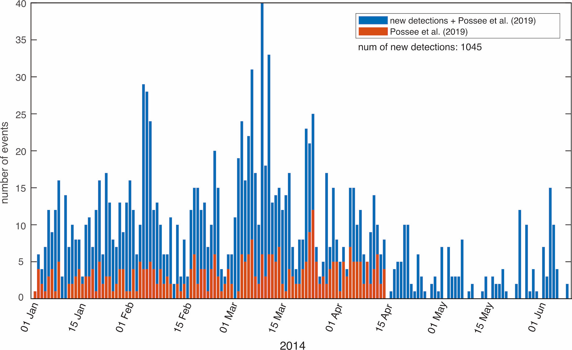
“In this study, we use the relocated events from the recently published catalog as template waveforms and apply a matched filtering technique that cross-correlates those templates with the continuous data in order to detect missing events,” the team wrote in their poster. The team increased the previously published earthquake catalog by a factor of three and located more than 1,000 earthquakes that weren’t in the previous catalog just between January and June 2014, Lee told Temblor. “With the addition of these new detections, we were able to better delineate the structures in southern Haiti,” she said. This may eventually “improve the seismic hazard map for this region, which can be used by engineers in building design,” she said.
This is just the start of the team’s work, Lee said. There’s much more to be done to add to the earthquake catalog over longer timeframes and to use additional seismic data from the Dominican Republic, the team noted in the poster.
Hunting for unusual quakes in subduction zones
Subduction zone earthquakes are complicated beasts. Quakes can occur in the subducting slab mantle, on the subducting crust, on the subduction interface or in the mantle wedge and determining a quakes’ location in the system is really hard. But it’s important because where the earthquake happens helps elucidate its generation mechanisms, according to Felix Palpaap, a postdoc at the University of Bergen in Germany, and his team, who presented their poster today.
Though intermediate-depth earthquakes are generally thought to occur in the slab mantle and in the slab crust, the team wrote in their abstract, “recent observations point out that some intermediate-depth earthquakes may occur in other, unusual places, such as on the deep portion (>50 km) of the subduction interface, and in the overlying mantle wedge.” Current techniques to locate these quakes, however, cannot pinpoint these locations.
So Palpaap and his team tried to pinpoint the location of these deep quakes from waveforms, or the shape of the seismic wave. They started by looking at the waveforms of small, local earthquakes. Then they modeled and analyzed how waves came out of generic simulated subduction zones using a novel three-step approach. They were able to identify the attributes of the waveforms coming out of each location — the subducting slab mantle, the subducting crust, the subduction interface and the mantle wedge. Then they applied this approach to the Western Hellenic subduction zone, where clusters of earthquakes have been previously observed in the mantle wedge, crustal slab and the interface.
“Our results highlight the strong potential of full-waveform analysis of local earthquakes to locate hypocenters precisely relative to subsurface structure and, in doing so, hunt for earthquakes that may occur in unusual environments,” the team wrote.
- When Tokyo’s next big earthquake hits, could global markets crash? - March 20, 2026
- The Earthquake that Shook the South - February 26, 2026
- Introducing Coulomb 4.0: Enhanced stress interaction and deformation software for research and teaching - February 20, 2026