Bent railroad tracks and a hidden fault may provide clues to an enduring mystery about the 1886 Charleston earthquake. But not everyone agrees.
By Rebecca Owen, science writer (@beccapox/@beccapox.bsky.social)
Citation: Owen, B., 2026, The Earthquake that Shook the South, Temblor, http://doi.org/10.32858/temblor.373

Few people think of South Carolina as a hotspot for earthquakes. Yet on August 31, 1886, one of the most destructive earthquakes in United States history struck Charleston. The estimated magnitude 7.0 event damaged or destroyed thousands of buildings in the region. Both damage and shaking were reported in cities hundreds of miles away, like Boston, Chicago and New Orleans. Sixty people lost their lives.
More than a century later, the Charleston earthquake continues to puzzle scientists. Because it occurred before modern seismological equipment existed, researchers are still debating which faults were involved and what this might mean for the region’s disaster preparedness in the future.
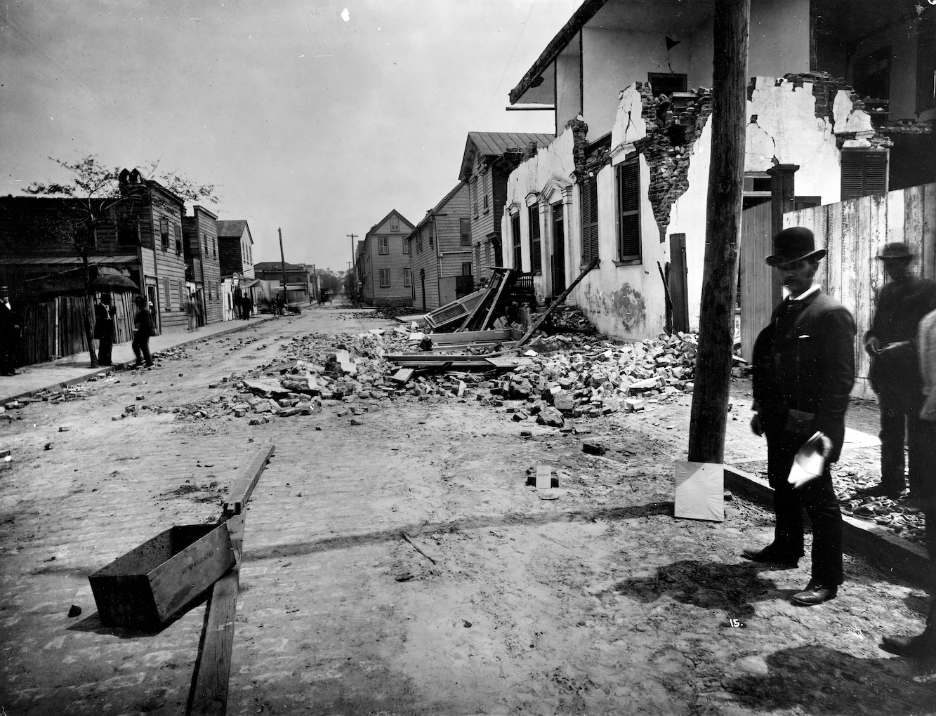
Today, there isn’t much surface evidence for this large quake. The sandy swamps and low-elevation forests of the Atlantic Coastal Plain mask any active faults or deformation that occurred that August night in 1886. Instead, the earthquake’s legacy remains visible in the built environment. Reinforced brick buildings impressively constructed before the earthquake. A graveyard with its headstones all shifted in one direction. Cracks in the walls of a historic fort. Bends in railroad tracks. Together, these features offer evidence of the earthquake’s force, even as scientists continue to debate its cause and implications.
South Carolina can shake
Unlike in the West, where people coexist with well-known faults, most East Coast residents don’t experience seismic activity or consider earthquake history as a part of daily life. But until the 20th century, the Charleston event was the largest and most destructive earthquake recorded in the United States. In fact, U.S. residents once had a very different view of the country’s seismic proclivities.
For a long time, even up until right before the San Francisco earthquake in 1906, everybody in the country thought that only South Carolina had big earthquakes,” says Martin Chapman, a seismologist from Virginia Tech.
The faults affecting this part of South Carolina don’t connect to other East Coast systems — like the faults crisscrossing the Appalachian mountains that have been tied to the 2024 earthquake felt in New York and New Jersey. Moreover, Charleston sits far from active plate boundaries, further deepening the mystery of the 1886 earthquake’s origin. There isn’t much debate on the size of the earthquake — around a magnitude 7 — but scientists still don’t agree on the specifics of the 19th century event.
“This Charleston fault always sits outside of any other tectonics in the East Coast of the U.S.,” says Dan Frost, a seismologist at the University of South Carolina and the director of the South Carolina Seismic Network. “If you look at the USGS-published map of earthquake hazard in the area, across the U.S, it’s all on the West Coast, Alaska, Hawaii, and then New Madrid around Memphis. Then you have Charleston, South Carolina, just this little red dot.”
Nearly 140 years later, researchers are still examining and interpreting Charleston’s historic earthquake. “There was no seismometer recording any of this,” Frost says. Today, seismometers provide the information needed to address key questions that remain about the 1886 event — how much the ground shook, what direction the fault moved, and even the geometry of the fault itself. So scientists must rely on other types of data, which has led to different perspectives and lack of consensus on this important East Coast quake.
Train tracks provide potential clues to a seismic mystery
In 2023, USGS geophysicist Sue Hough and geologist Roger Bilham from The Cooperative Institute for Research in Environmental Sciences at the University of Colorado Boulder co-authored a study that combined geology and history to build a new model and constrain when and exactly where the rupture may have occurred. Neither Hough nor Bilham was available for comment.
In the absence of seismic data, Hough and Bilham followed other lines of evidence. There’s an indication of uplift in the Penholoway Marine Terrace. Modern seismic reflection data provide x-ray-like images of subsurface fault offsets. Historical maps depict about a meter of uplift near the town of Summerville between 1886 and 1919, but no uplift at nearby Fort Dorchester.
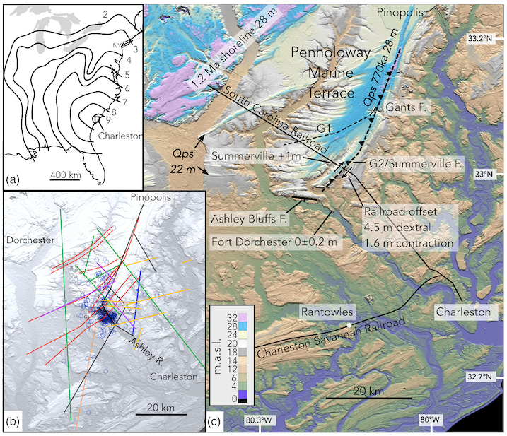
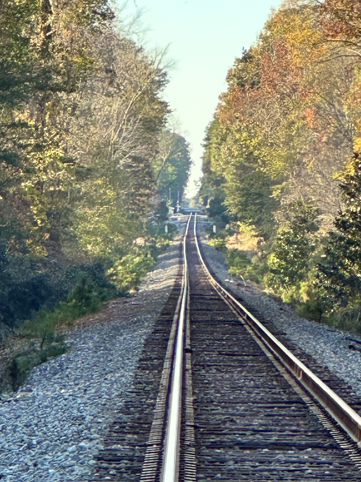
In November 2022, Hough and Bilham set out to locate railroad mile markers mentioned in archival reports. Using satellite imagery and GPS data, the researchers mapped the old South Carolina Railroad southeast of Summerville and found a previously unnoticed 4.5-meter right-lateral offset of the track. This sideways shift aligns with horizontal motion coupled with some oblique offset and suggests that the track displacement may have occurred during the 1886 earthquake. This, they wrote, is supported by borehole data revealing warping of the subsurface warping and archaeological evidence of sea-level rise.
Building on these historical observations, the Summerville Fault emerged as the most likely source of the earthquake. Hough and Bilham’s model suggests six meters of slip at depth and a magnitude of 7.3, with the strongest shaking felt near Summerville — matching with building damage reports captured at the time. These patterns were also consistent with the five- to seven- meter uplift they observed at the Penholoway Marine Terrace that would have occurred over the past 770,000 years or so, meaning that repeated ancient earthquakes may have shaped the landscape over hundreds of thousands of years.
A different perspective
After Hough and Bilham published their findings, another group of researchers (including Chapman) penned a comment that questioned some of the study’s claims. For instance, Chapman and colleagues’ previously published model showed reverse faulting — vertical motion with less horizontal slip than Hough and Bilham had interpreted.
Hough and Bilham suggested that the earthquake occurred entirely north of the Ashley River, along the west-dipping Summerville Fault. Earlier studies used topographic and geologic evidence to point to fault movement south of the Ashley River, according to Chapman. The comment suggests that railroad damage and evidence of liquefaction near the unincorporated area of Rantowles hint at stronger shaking to the south as well, aligning closer with Chapman’s previous modeling from 2016.
In the comment, Chapman and the other authors say that it’s not possible for the Penholoway Terrace to have been uplifted; instead, they say that its changes are caused by sediment buildup along an ancient shoreline. Topographic surveys, ground-penetrating radar, borehole data — none of these datasets show uplift or deformation along the fault, Chapman and coauthors write.
The bent railroad tracks are another point of contention. Chapman and coauthors suggest that Hough and Bilham’s reliance on one bent train track ignores that the track may have been rebuilt many times since 1886 and therefore may not record deformation from the earthquake. Without the track maintenance history, relying on the tracks as evidence of fault behavior presents uncertainty. Overall, the comment claims that Chapman’s 2016 rendering of the fault better fits the geological and historical record.
A response and a look to the future
After contending with the criticism from Chapman and the other researchers, Hough and Bilham revisited their own model in a published reply. They revised their interpretation of uplift of the Penholoway Marine Terrace. Instead of going up between five and seven meters, the terrace may have experienced local uplift only along the southeastern edge. This, they say, is supported by seismic reflection data showing folding. Moreover, archaeological data shows that Fort Dorchester rose 35 centimeters, counter to their initial work that indicated no uplift.
Another point of contention was how the Summerville Fault moved. Was the motion mostly horizontal strike-slip, with a minor vertical component, as Hough and Bilham’s original study suggested, or was it entirely strike-slip? The updated Hough and Bilham model proposed that the shallow Summerville Fault experienced only horizontal, right-lateral slip in 1886, with reverse oblique slip occurring on a separate fault below 5 kilometers. For this interpretation, Hough and Bilham relied on the right-lateral offset of the train tracks for near-surface constraints, with reverse oblique slip at depth constrained by geomorphology. Based on familiarity with railroad practices and observations from contemporary geologists, the duo rejected the claim by Chapman and colleagues that the offset track resulted from repairs.
Hough and Bilham ended their response with a suggestion that future studies focus on identifying additional evidence for fault movement in 1886, including further mining of other archival sources, like railroad maintenance records. As small earthquakes around the Charleston area continue to occur, more investigation of this region and its complicated fault system is warranted. A clearer understanding of the 1886 event would refine the historical record and improve present-day seismic hazard assessments for South Carolina and surrounding areas.
Another concern
An additional possibility to consider is that the Charleston earthquake may also be one event in an earthquake sequence, according to Frost, who was not involved in either set of studies. Creeks in the area may preserve evidence of earthquakes in the form of sand blows. “These sand blows are evidence of liquefaction that occurs in the earthquakes. Liquefaction occurs, and suddenly you have a liquefied layer of sand,” says Frost. “And that can erupt through other layers.”
Researchers have gone into the rivers and creeks, avoided water snakes (of which there are many, says Frost), and — through evidence from the sand blows and carbon dating other organic matter — found traces of earthquake activity going back 3,000 years. “Every 500 years, roughly, approximately, there was an earthquake of the scale of the Charleston earthquake. That’s kind of the best information we have since this is such a low seismic activity area,” Frost explains.
Because these types of destructive events occur so infrequently here, they aren’t contained within the collective memory of the region. Learning more about this fault system and its behavior can help South Carolinians prepare, protecting themselves and their property. Continued research will help build a fuller picture of the faults that tangle below Earth’s surface.
Understanding what happened in 1886 is important for how we calculate seismic risk, or seismic hazard,” says Chapman. “We want to know the tectonic causes for this earthquake, and the types of geologic features that it occurred on. The question is: Is this the only place that’s active on the southeastern United States coastline or are there other areas?”
Copyright
Text © 2026 Temblor. CC BY-NC-ND 4.0
We publish our work — articles and maps made by Temblor — under a Creative Commons Attribution-NonCommercial-NoDerivatives 4.0 International (CC BY-NC-ND 4.0) license.
For more information, please see our Republishing Guidelines or reach out to news@temblor.net with any questions.
- Venezuela’s doublet leaned toward Caracas - June 30, 2026
- Is Southern California’s Cajon Pass an ‘earthquake gate’ ready to open? - June 29, 2026
- Philippines magnitude 7.8 shock may have loaded the central Cotabato subduction zone - June 11, 2026