An offshore magnitude-6.0 earthquake on January 3 rattled the Taipei metropolitan area, but cities closer to the epicenter felt only light shaking.
By Wei-An Chen, B.S., and Chung-Han Chan, Ph.D., Earthquake Disaster & Risk Evaluation and Management Center (E-DREaM)
Citation: Chen, W., Chan, C., 2022, Northern Taiwan starts the new year with a jolt, Temblor, http://doi.org/10.32858/temblor.234
This article is also available in Traditional Chinese.

A magnitude-6.0 earthquake struck off the east coast of Taiwan on January 3, 2022, showing that faults are not going to take a break even for new year holidays.
Shaking was felt throughout the island’s northern cities, reminding Taiwanese that they are living on a seismically active island. Scientists are constantly working to better understand earthquakes to help mitigate losses from strong shaking.
January’s earthquake took place in the Ryukyu subduction system, where the Philippine Sea Plate subducts to the North, beneath the Eurasia Plate. The earthquake struck 19.4 kilometers below the surface, on the southernmost segment of the interface between these plates. The region is seismically active; more than 10 magnitude-6.0 and greater events have struck nearby in the past three decades.
Patchy shaking patterns
Ground shaking intensity usually decays with the distance from the origin of an earthquake. In the case of January’s earthquake, however, shaking was patchy. For instance, Taipei City — 130 kilometers away from the epicenter — experienced ground shaking up to 30.6 gal (Modified Mercalli intensity IV). Yet, in Hualien City, only 58 kilometers (36 miles) away from the earthquake, shaking reached only around 7.9 gal.
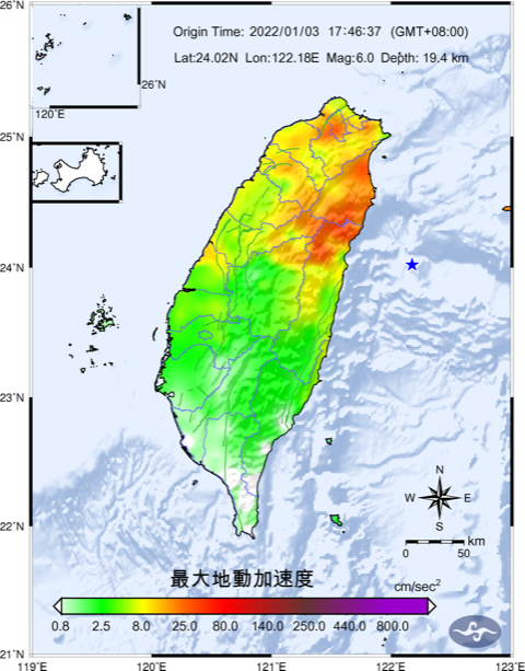
This pattern is related to the ground beneath Taipei City, which is made up of soft sediments surrounded by hills made of stiff soil. Such “basins” trap seismic and amplify ground shaking, like a bowl of jelly. Similar effects were observed during the magnitude-7.1 Hualien earthquake in 2002. Despite striking far from Taipei City, this event caused high ground shaking intensity, resulting in significant damage; Hundreds of buildings were damaged and a tower crane working on Taipei 101 collapsed.
Strong shaking was not restricted to Taipei. Shaking was significant throughout northern Taiwan, whereas in areas to the south, close to the epicenter, the effect was minimal. Such heterogeneous distribution could also be attributed to the earthquake itself. Earthquakes happen when a section of a fault slips. Such a “rupture” generally starts at a point and propagates along the boundary, as the area the slipped grows. The seismic waves traveling in the same direction as the propagating rupture are compressed and amplified, intensifying shaking. This phenomenon is also known as the “Doppler effect.” During the January 3 earthquake, slip on the fault propagated to the northwest with maximum slip of 26 centimeters (10 inches). The waves traveling towards northern Taiwan were therefore amplified.
Seismologists noticed a similar effect during the magnitude-6.4 Meinong earthquake, which struck southern Taiwan in 2016. This event ruptured westward from the nucleation point, below the epicenter, causing stronger ground shaking and damage in that direction.
Ryukyu Trench could host an even bigger earthquake
GPS data collected on the northeast coast of Taiwan indicate that the Ryukyu subduction zone is locked, according to an analysis by Ya-Ju Hsu, a seismologist at the Institute of Earth Sciences, Academia Sinica, Taiwan. Along the boundary, frictional resistance is greater than the stress of the plates moving past one another. An earthquake occurs when that force overcomes friction.
Seismological and geodetic evidence suggests that enough stress has built on the boundary to generate a magnitude-8.0 or larger megathrust earthquake. Such an earthquake could cause widespread damage from violent shaking and a major tsunami.
Although earthquakes around magnitude 6.0, such as the one on January 3, sometimes take place in the subduction zone, the energy they release is negligible compared to that of a magnitude-8.0 event. After a smaller magnitude-6.0 event, there is still enough stress on the boundary for a magnitude-8.0 earthquake.

To quantify the seismic hazard and risk from the subduction zone, scientists from National Central University, Sinotech Engineering Consultants, Inc., National Science and Technology Center for Disaster Reduction and National Center for Research on Earthquake Engineering worked together to simulate a ground shaking scenario for a future magnitude-8.0 earthquake along the Ryukyu subduction interface. The resulting shake map shows that ground shaking would be severe in central Hualien County, due to its proximity to the interface. By further considering the distribution of buildings, population and infrastructure, researchers could take this analysis further and calculate losses from such an event, including the distribution of building, road, bridge and cell tower damage, fatalities, fires, electricity interruption and requirement of sheltering. This scenario became the basis for the drill on National Disaster Preparedness Day in September 2021.
There is no doubt that the Ryukyu subduction system is one of the major threats to Taiwan. An event at the southernmost segment in this system could result in significant ground shaking along the eastern coast Taiwan and even the Taipei metropolitan area. Thus, it is crucial to boost awareness and fortify communities against major damage by enhancing buildings that are vulnerable to earthquake damage.
References
Hsu, Y. J., Ando, M., Yu, S. B., & Simons, M. (2012). The potential for a great earthquake along the southernmost Ryukyu subduction zone. Geophysical research letters, 39(14).
Wu, Y. M., Liang, W. T., Mittal, H., Chao, W. A., Lin, C. H., Huang, B. S., & Lin, C. M. (2016). Performance of a low-cost earthquake early warning system (P-alert) during the 2016 ML 6.4 Meinong (Taiwan) earthquake. Seismological Research Letters, 87(5), 1050-1059.
https://www.facebook.com/photo?fbid=4695369193832397&set=pcb.5161435350541386
- Venezuela’s doublet leaned toward Caracas - June 30, 2026
- Is Southern California’s Cajon Pass an ‘earthquake gate’ ready to open? - June 29, 2026
- Philippines magnitude 7.8 shock may have loaded the central Cotabato subduction zone - June 11, 2026