By David Jacobson, Ross Stein, and Volkan Sevilgen, Temblor
Citation:Jacobson D.S., Stein R.S., Sevilgen V., 2017, Which fault ruptured in the M=6.6 Kos-Bodrum earthquake?, Temblor, http://doi.org/10.32858/temblor.007

Last week, there were large earthquakes along the Greece-Turkey border near the tourist hotspots of Kos and Bodrum, and just north of the Commander Islands on the Aleutian Arc. Now that several days have passed, we have been able to further analyze these quakes and their aftershock sequences, in order to better understand the dynamics of these earthquakes.
In the five days since the M=6.6 Kos-Bodrum earthquake, there have been approximately 400 M=2+ aftershocks. Based on the magnitude of the mainshock, this quake likely had a rupture length of 20 km. In the figure below, we show how the aftershock sequence looked mere hours after the earthquake, four days later, and coulomb stress changes associated with the mainshock. This figure highlights several earthquake characteristics. First, when the top two panels are compared, one can see that while the top figure does not contain many aftershocks, it does an excellent job encompassing the future aftershock zone shown in panel two, where the area just filled in.

It is also important to note that this aftershock sequence has a rough barbell shape, which matches the coulomb stress changes imparted by the mainshock. It should be pointed out that the coulomb calculation assumes a compact source and that the earthquake occurred on a north-dipping structure, possibly an extension of the Datca Fault. Initially, we stated that the Gokova Fault was the likely culprit, but because the aftershock sequence aligned better with the strike of the north-dipping structure, it was chosen for coulomb. However, there is still great uncertainty as to which fault ruptured. Nonetheless, this could help explain why there was more damage reported in Kos, as the fault is closer to Greece, and the earthquake would have ruptured towards Kos. However, discrepancies in damage could also be due to a variety of other factors.
A second look at the M=7.7 Commander Islands earthquake
In the Commander Islands, along the western extent of the Aleutian Arc, we can now say that the M=7.7 earthquake a little over a week ago likely ruptured the Bering Fault Zone, a right-lateral strike-slip system separating the Aleutian Ridge from the Commander Basin (Gaedicke et al., 2000). This fault zone is part of the larger Komandorsky fracture system, which comprises the North American-Pacific plate boundary. Based on the lack of many large historic earthquakes, the Bering Fault Zone was thought to have a lower seismic potential than the fault zones to the south, Pikezh, Steller, and Aleutian, which are believed to take up the majority of displacement along the plate boundary.
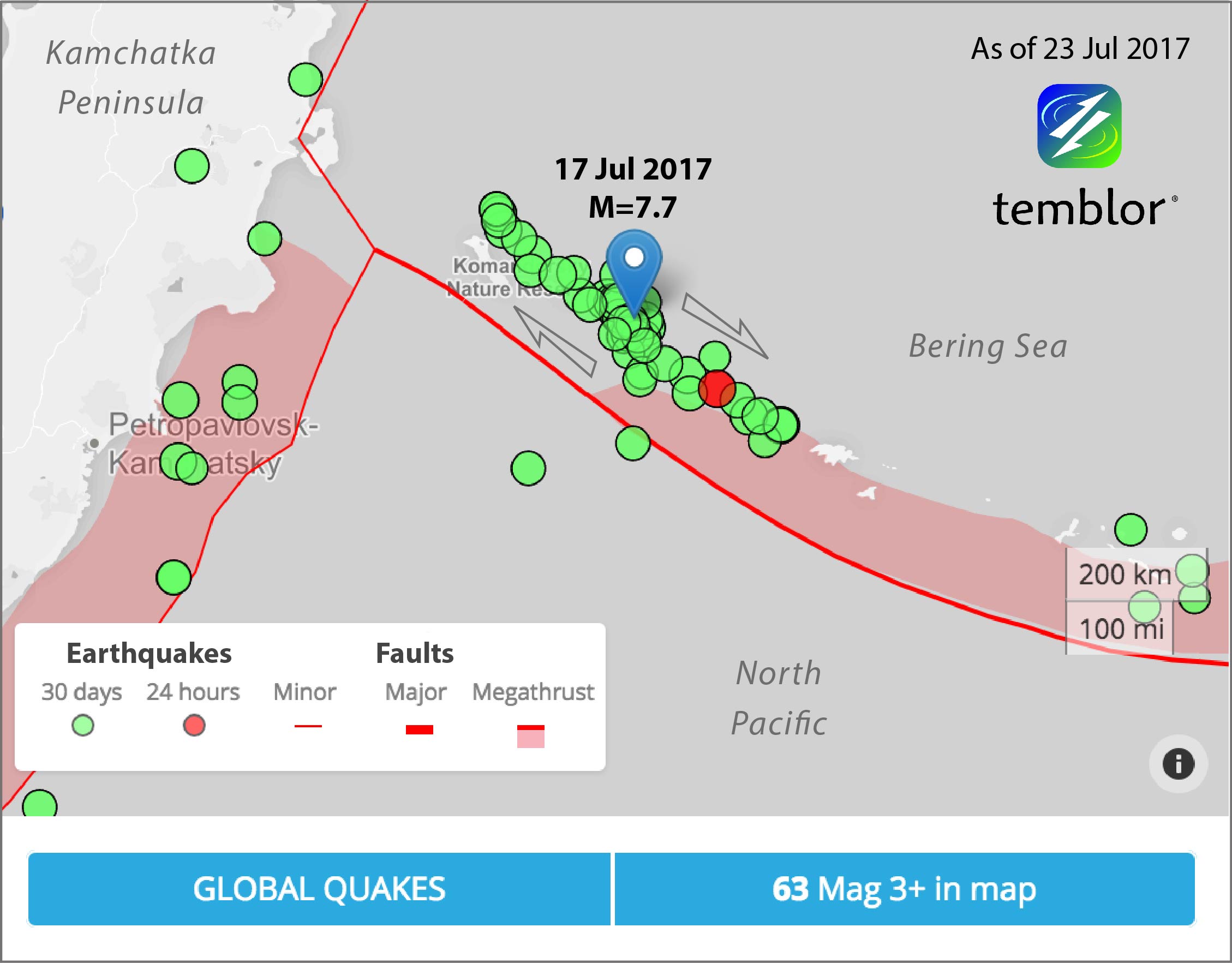
In the week since the mainshock, there have been 46 M=4+ aftershocks, the largest of which was a M=5.3, stretching for a distance of over 600 km. While the aftershock sequence from the Kos-Bodrum earthquake just became more dense, along the Commander Islands, it not only became more dense but lengthened by about 10-15%. This suggests very strong end lobes of stress. Gavin Hayes of the USGS is also producing an updated Finite Fault model today, and when that comes out we will know more about this earthquake and will update this post.
Citation:Jacobson D.S., Stein R.S., Sevilgen V., 2017, Which fault ruptured in the M=6.6 Kos-Bodrum earthquake?, Temblor, http://doi.org/10.32858/temblor.007
References
European-Mediterranean Seismological Centre (EMSC)
USGS
Christoph Gaedicke, Boris Baranov, Nokolay Seliverstov, Dmitry Alexeiev, Nikolay Tsukanov, and Ralf Freitag, Structure of an active arc-continent collision area: the Aleutian-Kamchatka junction, Tectonophysics 325 (2000) 63-85
Huseyin Tur, Cenk Yaltırak, Irem Elitez, Kerim Tuncer Sarıkavak, Pliocene-Quaternary tectonic evolution of the Gulf of Gokova, southwest Turkey, Tectonophysics 638 (2015) 158-176
- Earthquake science illuminates landslide behavior - June 13, 2025
- Destruction and Transformation: Lessons learned from the 2015 Gorkha, Nepal, earthquake - April 25, 2025
- Knock, knock, knocking on your door – the Julian earthquake in southern California issues reminder to be prepared - April 24, 2025