By David Jacobson, Temblor
See earthquakes in British Columbia

This morning, British Columbia and southeastern Alaska, 200 km northwest of the capital city of Juneau, was struck by M=6.2 and M=6.3 earthquakes within two hours of each another. The first quake hit at just past 4:30 a.m., while the M=6.3 aftershock occurred at 6:18 a.m, 11 km away. Both of these earthquakes were shallow, 2 km and 10 km respectively, and were widely felt throughout the area. Close to the epicenter, very strong shaking was recorded. Fortunately, the region is not densely populated as the nearest city, Whitehorse, Canada (Pop: 23,000), is 150 km away. The USGS estimates that economic losses should remain minimal and casualties are unlikely. However, reports are still coming.
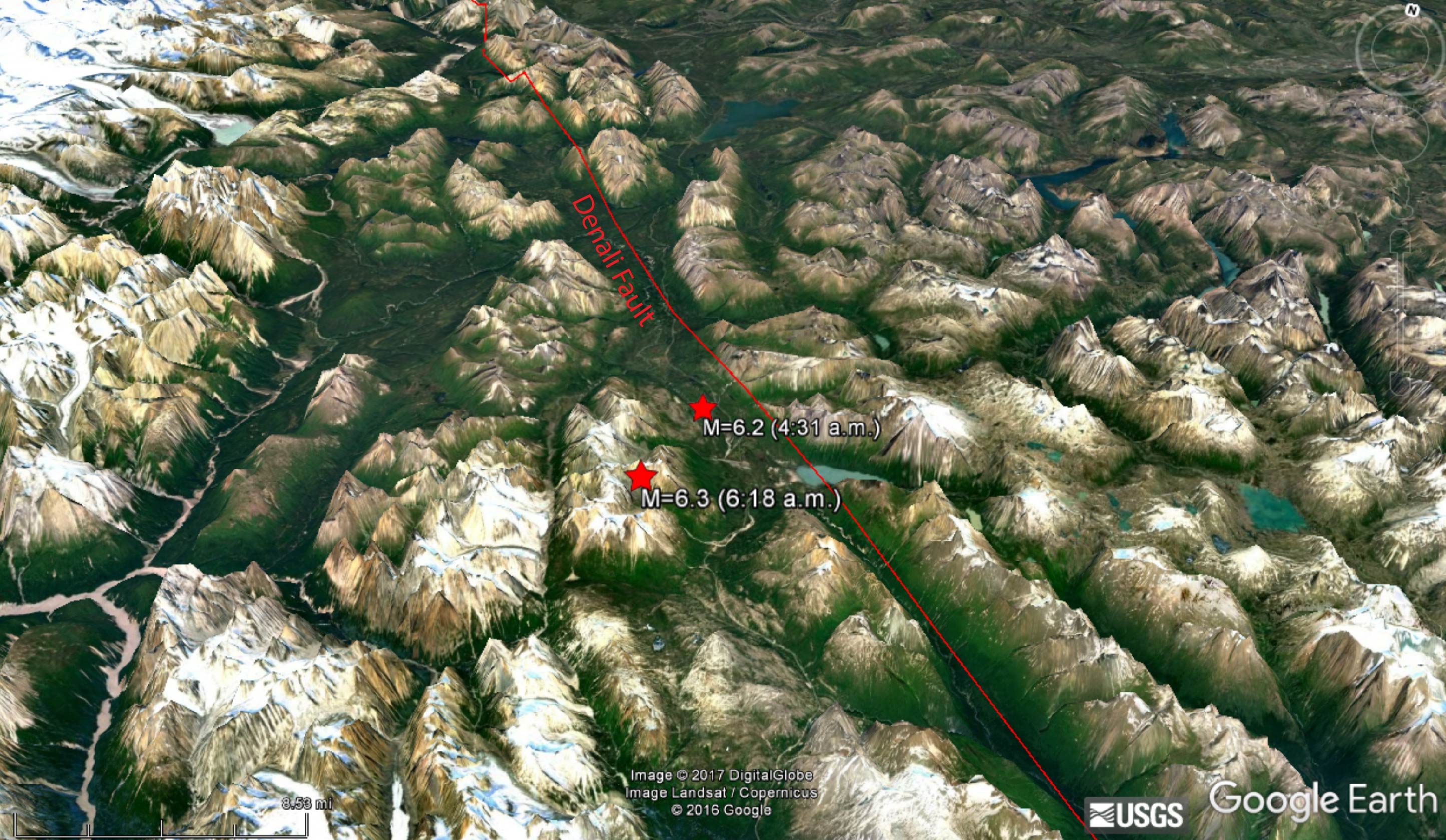
When most people think of earthquakes in Alaska and British Columbia they think of large subduction zone quakes like the M=9.2 1964 Good Friday earthquake that caused over $300 million in damage, triggered a deadly tsunami, and killed 139 people. However, based on data so far, as well as the location of today’s earthquakes, these were likely associated with the Denali Fault, where slip is approximately 2 mm/yr (Wesson et al., 1999). Having said that, neither of the focal mechanisms show slip parallel to the fault, suggesting these quakes occurred on secondary structures.
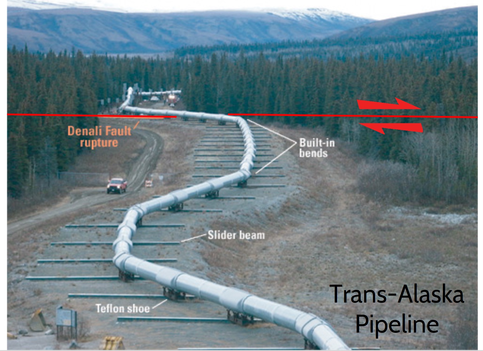
The Denali Fault is a major right-lateral strike-slip fault that extends from northwestern British Columbia in Canada to central Alaska. Prior to 2002, the Denali Fault had been relatively inactive, averaging four M=3 earthquakes per year. However, on November 3, a M=7.9 earthquake ruptured a 340 km segment of both the Denali and Totschunda faults to the northwest of today’s events. To date, this is the largest earthquake in Alaska’s interior.
Even though the earthquake was significant in magnitude, and similar to San Francisco’s 1906 earthquake, because most of Alaska is sparsely populated, the quake caused no fatalities and little damage. One of the more famous aspects of the 2002 Denali fault earthquake is that the rupture area crossed the Trans-Alaska Pipeline, which carries 17% of the U.S. domestic oil supply. Even though fault offset underneath the pipeline reached 14 ft horizontally and 2.5 feet vertically, no oil was spilled as the pipeline is built on sliders, and capable of withstanding large fault movement. The fact that not a single drop was spilled is a triumph in earth science and engineering, as an environmental disaster would have resulted had the pipeline ruptured.
While today’s two large magnitude earthquakes will likely only cause minor disruption in the form of power outages and nervous residents, it is still important to address these quakes and look at how likely they were. By using the Global Earthquake Activity Rate (GEAR) model in Temblor, we can see that these quakes should not be viewed as surprising. This model uses global strain rates and seismicity since 1977 to estimate the likely earthquake magnitude anywhere on earth in your lifetime. In the map below, it can be seen that M=6.0+ quakes are likely. To view the model, click here. Even though M=6.0+ earthquakes are likely in your lifetime, by looking at the USGS earthquake catalog, none have occurred recently, as the majority of the quakes occur closer to the subduction zone to the west. Nonetheless, it was a literal wake up call, for people in British Columbia and southeastern Alaska.

Reference
USGS
Robert L. Wesson, Arthur D. Frankel, Charles S. Mueller, and Stephen C. Harmsen, Probabilistic Seismic Hazard – Maps of Alaska, 1999, Open-File Report 99-36.
- Earthquake science illuminates landslide behavior - June 13, 2025
- Destruction and Transformation: Lessons learned from the 2015 Gorkha, Nepal, earthquake - April 25, 2025
- Knock, knock, knocking on your door – the Julian earthquake in southern California issues reminder to be prepared - April 24, 2025