By David Jacobson, Temblor
Check your seismic hazard rank

The San Francisco Seawall was a key factor in turning San Francisco into the prosperous city it is today. Its construction, which took place from 1879-1916 allowed for tidal marshlands to be turned into the Embarcadero, and over 500 acres of downtown San Francisco. However, the Seawall is at risk from a serious threat, earthquakes.
Last July, in a joint venture by GHD and GTC, two engineering consultants, a report on the Seawall’s earthquake vulnerability was prepared for the Port of San Francisco. In it, they highlighted the “greater than expected risk to the Seawall,” and strategies which could be taken to seismically retrofit it. This report, and more, was further highlighted at the 14th Annual Northern California Earthquake Hazards Workshop at NASA this last Tuesday and Wednesday.

According to the USGS, there is a 72% chance that a M=6.7 earthquake will hit the Bay Area by 2043, with the majority of the hazard coming from the San Andreas, Hayward, and Calaveras faults. In the event of a large earthquake, shaking will likely be severe, which could result in significant damage to the Seawall and the infrastructure it stabilizes.
Of primary concern to the engineers and Port of San Francisco, is the potential for liquefaction and lateral spreading underneath and around the Seawall. Liquefaction is a process whereby saturated soil behaves like a liquid under intense shaking. Lateral spreading is when the ground slides down shallow slopes during earthquakes, often causing large cracks to form. These phenomena are possible as the soil in the area is either artificial fill or young bay mud, both of which are highly susceptible to ground failure. Additionally, they are known to have occurred along the waterfront during the 1906 M=7.8 San Francisco earthquake.

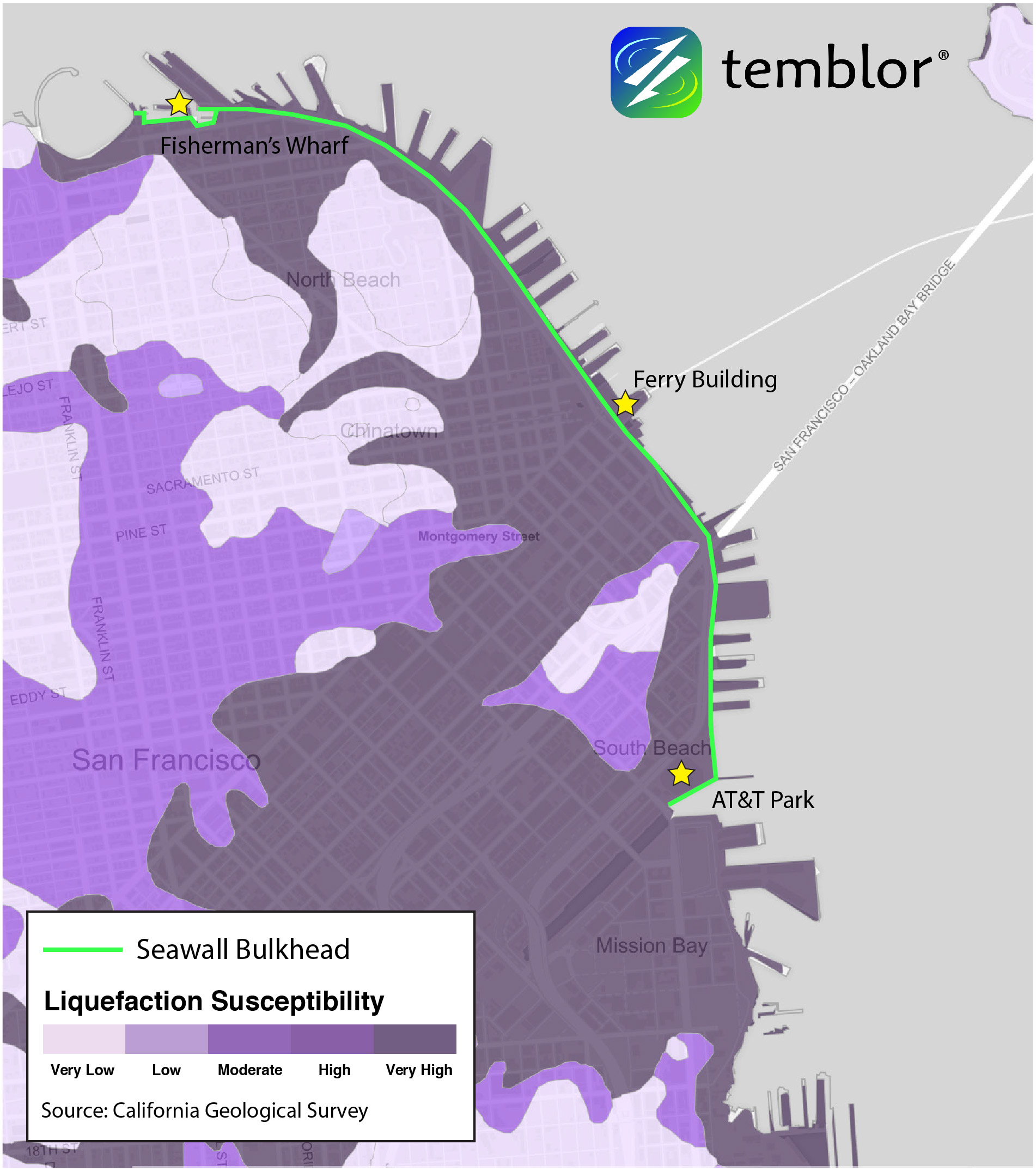
If liquefaction or lateral spreading do occur in a large Bay Area earthquake, various things could happen. First, the Seawall could slide Bayward, resulting in damage or collapse of wharf structures. Additionally, the bulkhead wall, which caps the rock Seawall, could undergo damage or failure. Such failure to the Seawall, which is over 100 years old , would have devastating impacts to San Francisco.
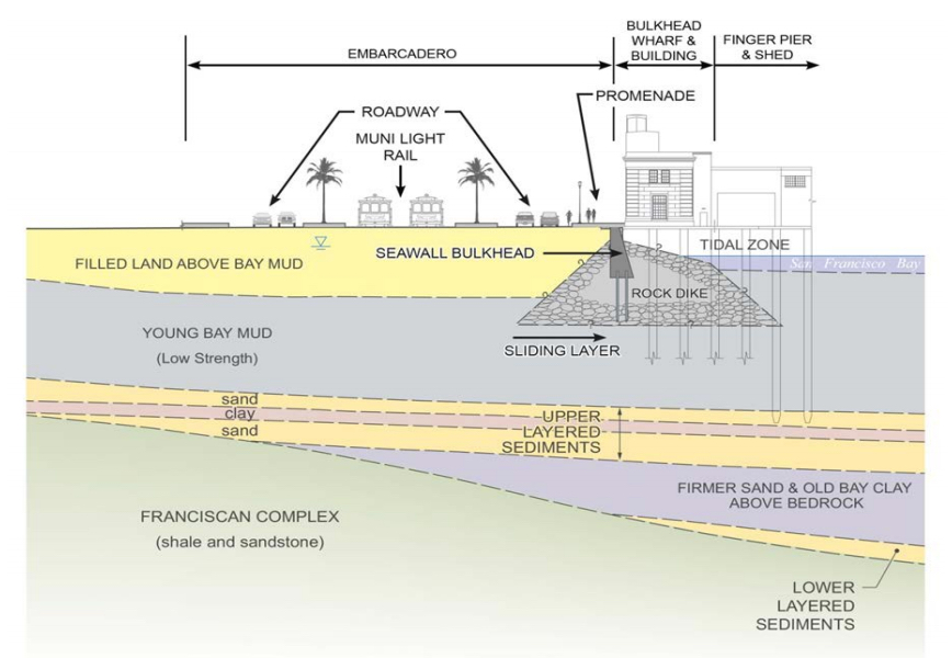
The Seawall currently stabilizes the Ferry Building and Terminal, finger piers, historic bulkhead wharf structures, the Embarcadero, and so much more. The loss of one or all of these would cause extreme disruption, leading to significant economic losses. This area, through business and tourism, generates billions of dollars of revenue for the city each year. Additionally, transportation lines and utilities services would likely be lost for the waterfront and large parts of the city. Because of these huge impacts, mitigation methods have been proposed.

Because of the scale of this project, all mitigation methods are substantial, which in turn makes them very costly. At the Northern California Earthquake Hazards Workshop, Steven Reel, a Project Engineer at the Port of San Francisco highlighted four options. Option 1: Liquefaction remediation of fill. This option focuses on improving the stability of the soil behind the seawall in an attempt to decrease liquefaction effects. Option 2: Ground improvements under the Seawall. A technique known as jet grouting would be used to strengthen the young bay mud. Option 3: Ground improvements landside of the Seawall, combined with bulkhead retrofits. This is similar to Option 1, but more extensive. Option 4: New Bayward Seawall. This project would involve building an entirely new Seawall farther out in the Bay.
While these options may seem extreme, the loss of functionality of a large portion of the waterfront would be devastating to San Francisco. It should also be mentioned that these retrofits would also attempt to combat global sea level rise, which could be 12-24 inches by 2050.
Costs for all these projects vary significantly. To only address immediate life safety upgrades will cost an estimated $500 million. However, this would not address the larger problems, and a full-scale retrofit is estimated at $2-5 billion. The city has already gotten behind a Seawall resilience project, and in 2018, San Francisco residents will vote on a bond which would allow for $350 million to be spent on the first round of upgrades.
As this story progresses, we at Temblor will be sure to provide any necessary updates.
Sources
GHD-GTC Seawall Earthquake Vulnerability Study
Steven Reel’s slides on “The Northern Waterfront Seawall History and Earthquake Performance”
Steven Reel’s talk at the 14th Annual Northern California Earthquake Hazards Workshop (January 24, 2017)
Port of San Francisco
USGS
SFGate
- Earthquake science illuminates landslide behavior - June 13, 2025
- Destruction and Transformation: Lessons learned from the 2015 Gorkha, Nepal, earthquake - April 25, 2025
- Knock, knock, knocking on your door – the Julian earthquake in southern California issues reminder to be prepared - April 24, 2025