By David Jacobson and Ross Stein, Temblor
Citation: Jacobson D., Stein R.S., 2016, 14 November 2016 Mw=7.8 New Zealand earthquake shows an uncanny resemblance to the 2015 Nepal shock, Temblor, http://doi.org/10.32858/temblor.004
At 12:02 a.m. local time on November 14, a Mw=7.8 (per USGS), Mw=7.5 (per GNS Science, NZ) earthquake struck New Zealand’s South Island, and caused tsunami warnings to be issued for all of New Zealand’s east coast. Even though the epicenter was on land, tsunami warnings were issued, according to GNS Scientist Bill Fry, because the fault projected offshore, and the earthquake source involved thrust motion, which can lift or drop the sea floor. So far, the largest recorded waves were 2 m (6 ft) high.
Today’s earthquake, which was centered approximately 100 km (60 miles) north of Christchurch, near the small town of Culverdon, was widely felt over both the North and South Islands. So far, only two fatalities are confirmed, but there was significant damage, and vast areas remain without power.
Widespread Damage
The majority of damage from this quake appears to be centered around and to the north of the epicenter, including in the capital city of Wellington. Landslides, rockfalls, building collapses and large surface cracks have been reported near the epicenter, while in Wellington, the ferry terminal collapsed, building facades came down, and broken glass littered the street.

This earthquake struck on the Marlborough Fault System, which occupies much of the northeastern portion of New Zealand’s South Island. The area is being both compressed and sheared, and contains many active northeast-southwest trending faults that link up with the Alpine Fault, the master fault demarking the Pacific-Australian plate boundary in New Zealand, much as the San Andreas is the master fault of the Pacific-North America plate boundary on the other side of the Pacific.
Did the quake nucleate on a blind thrust fault?
Determining which fault slipped was not initially clear. Scientists first looked to the Hope Fault, the most active fault in the region, which last ruptured in 1888 (M=7.0 – 7.3). However, according to Pennsylvania State University geophysicist Kevin Furlong, the earthquake is incompatible with the Hope Fault. The preliminary rupture model released by Gavin Hayes at the USGS in Golden, CO, places the majority of slip near the Kekerengu Fault, 120 km northeast of the epicenter. In fact, there appears to be very little slip near the epicenter.

Now however, scientists at GNS Science have been able to examine the fault rupture more carefully, and have determined key aspects about the earthquake. Their most important discovery is that it was not one fault that ruptured, but four, including a newly identified fault in Waipapa Bay (See figure below). Displacement along the Kekerengu Fault was the most significant, in some places reaching 10 m (33 ft). For at least one house, this displacement completely ripped it off its foundations. Multi-fault ruptures such as the one yesterday are common in New Zealand. In 2010, the M=7.1 Darfield Earthquake jumped multiple segments in a single earthquake that caused significant damage.


Additionally, Shinji Toda at Tohoku University graciously provided coulomb analysis showing areas of increased and decreased stress throughout New Zealand following the 14 November 2016 M=7.8 earthquake. His analysis shows that the Wellington and Wairarapa faults on New Zealand’s North Island may be closer to failure. You can follow aftershocks in New Zealand on Temblor.

New Zealand and Nepal quakes: Twins in every respect but lives lost

In terms of its rupture, the New Zealand earthquake is a ‘deja vu’ experience with the 25 April 2016 Mw=7.8 Nepal earthquake. Both show almost no fault slip at their epicenters, with the seismic waves traveling at about 5,000 mile per hour for about 50-100 km before the fault began to unzip. In the case of the Nepal quake, this placed much of the strong shaking beneath densely-populated and poorly-constructed Kathmandu, taking 9,000 lives. The New Zealand shock ruptured away from Christchurch, toward Wellington, but in a lightly populated part of the country, sparing lives—but putting Wellington on notice.
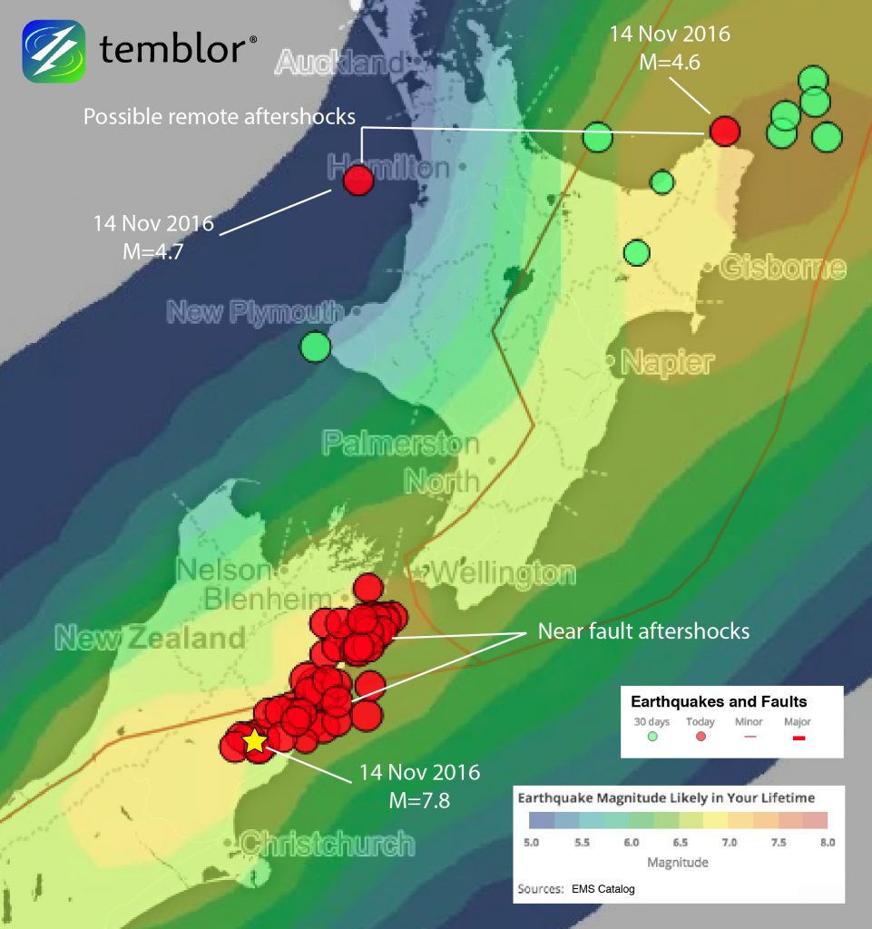
There are two candidates for aftershocks remotely triggered by the dynamic stresses carried by the seismic waves of today’s mainshock. These M=4.6 and M=4.7 shocks lie 600-800 km (250-500 mi) to the north and northwest of the mainshock. However, there is no smoking gun, as they did not strike when the waves arrived, but were delayed by 2-4 hours. This also occurred in Nepal shock, with remote aftershocks continuing over several weeks.
Nepal was unlucky enough to sustain the strongest shaking in the country’s capital, whereas New Zealand’s capital escaped today’s event. But just as dramatic are their different building construction standards and materials: New Zealand is one of the safest earthquake-prone countries in the world, whereas Nepal remains extremely vulnerable.
If we ever needed motivation to build better, this is it.
Check your hazard rank in Temblor
Updated: 15 November 2016 at 3 p.m.
Citation: Jacobson D., Stein R.S., 2016, 14 November 2016 Mw=7.8 New Zealand earthquake shows an uncanny resemblance to the 2015 Nepal shock, Temblor, http://doi.org/10.32858/temblor.004
References:
Stuff.co.nz
New York Times
GNS Science
GeoNet
USGS
Newshub.co.nz
Jean-Philippe Avouac, Lingsen Meng, Shengji Wei, Teng Wang & Jean-Paul Ampuero (2015), Lower edge of locked Main Himalayan Thrust unzipped by the 2015 Gorkha earthquake, Nature Geoscience 8, 708–711, doi:10.1038/ngeo2518
- Earthquake science illuminates landslide behavior - June 13, 2025
- Destruction and Transformation: Lessons learned from the 2015 Gorkha, Nepal, earthquake - April 25, 2025
- Knock, knock, knocking on your door – the Julian earthquake in southern California issues reminder to be prepared - April 24, 2025