By Tiegan Hobbs, Ph.D., Postdoctoral Seismic Risk Scientist, Temblor (@THobbsGeo)
Shinji Toda, Ph.D., IRIDeS, Tohoku University
A magnitude 6.5 earthquake hit a remote region of Idaho on March 31. Despite being in the same state, fears of Yellowstone reawakening are unfounded.
Citation: Hobbs, Tiegan, and Toda, Shinji, 2020, Significant Idaho earthquake unlikely to cause unrest in Yellowstone, Temblor, http://doi.org/10.32858/temblor.081
Article augmented (bottom) on April 1st, 2020, at 19:00 Eastern Standard Time to reflect most recent seismicity in Yellowstone.
Magnitude 6.5 quake strikes Idaho
A significant earthquake has struck a remote region of central Idaho, about 80 miles (130 kilometers) northeast of Boise. Although the magnitude 6.5 quake was widely felt in the western states and Canada, no damage has been reported other than rocks on the highway. No fatalities are expected. Despite being near Yellowstone, researchers at the Yellowstone Volcano Observatory have repeatedly confirmed that earthquakes like these are unlikely to trigger an eruption. Aftershocks, however, will continue over the coming days and weeks. For a typical magnitude 6.5 earthquake, the largest aftershock will have a magnitude of roughly 5.5.
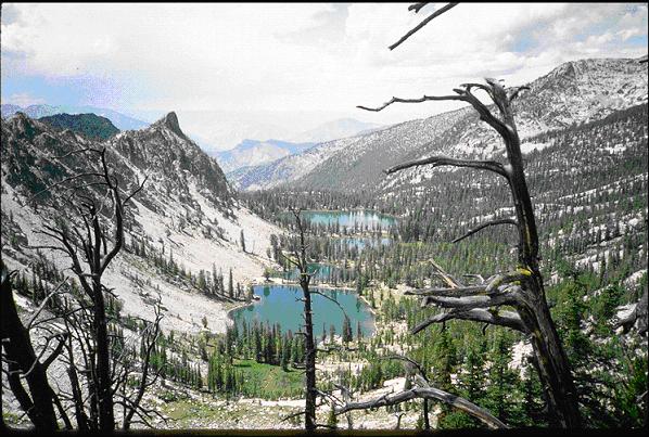
The earthquake, which occurred in the Challis National Forest, was 13.5 kilometers (8.5 miles) deep according to the United States Geological Survey (USGS). While a shallow event like this would usually cause significant damage to nearby towns, the remote location of the earthquake means that damage is expected to be low and no fatalities are expected.
Aftershocks and potential triggering on the nearby Sawtooth Fault
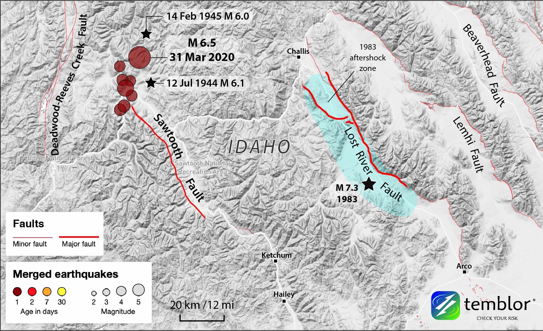
According to the USGS, there is a 4% chance of a larger earthquake occurring as a result of today’s event. Within half an hour of the mainshock, a magnitude 4.6 aftershock was recorded roughly 15 kilometers (10 miles) south. Aftershocks will continue for weeks, although their frequency and magnitude will decay with time.
So far, aftershocks extend southward from the mainshock, towards the nearby Sawtooth Fault. Stress modeling shows that the magnitude 6.5 earthquake has increased the stress on the Sawtooth, pushing it closer to an earthquake. The Sawtooth fault is thought to have ruptured twice in the last 11,700 years, with the most recent event being about 4,000 years ago.

To catch an aftershock
Scientists are working hard to collect information about the earthquake and its aftershocks, despite tremendous challenges in access. Problems with rapid data collection following this event are due to the ruggedness and remoteness of the epicenter within the Sawtooth Mountains, the more than a foot of fresh snow that continues to fall, and the ongoing COVID-19 pandemic, according to Drs. Claudio Berti and Zach Lifton of the Idaho Geological Survey.
The nearby mountain town of Stanley, which doesn’t have a hospital, has urged visitors to stay away in order to protect its 65 full time residents from potential coronavirus exposure. Therefore, it is untenable to send large contingents of scientists into these hills. Even without COVD-19, the main highway into the area, Highway 21, has been blocked by several rockfalls, according to Lifton. Crews are working to clear these as well as at least one avalanche, which may have resulted from the earthquake or simply from the vast accumulation of snow in the last day.
Despite these limitations, Berti is hopeful that a small team of collaborators at Boise State University may be able to install a handful of instruments in the area tomorrow. There is also the possibility of an aerial reconnaissance mission, which would allow the National Guard and the Geological Survey to assess the damage.
Complex earthquake near Yellowstone
USGS focal mechanism for M6.5 Idaho earthquake indicates strike-slip faulting, but has a large non double couple component (50%), so this might be a complex event. Borah Peak sequence to the East was normal faulting. https://t.co/wbFnmG2BKX pic.twitter.com/zaDLJosd4m
— Jascha Polet (@CPPGeophysics) April 1, 2020
Preliminary reports suggest that the earthquake is “complex”. What does this mean? In most earthquakes, the two sides of a fault slide past one another either vertically or horizontally. When a seismometer records non-earthquake sources, like very large bombs or volcanic eruptions, the signal looks different due to the explosive nature of the source. Tonight’s earthquake had a combination of earthquake-type and non-earthquake-type signals, according to Dr. Jascha Polet, professor of geophysics at California State Polytechnic University. We won’t know more until we collect more data, but Lifton says there’s no volcanism in the area of the earthquake that could be contributing to the signal.
The Idaho quake is not Yellowstone. It is over 200 miles away. Eruptions only happen when the magma moves from a chamber to the surface – and the small shaking from a quake that far away doesn't suddenly set all the magma moving.
— Dr. Lucy Jones (@DrLucyJones) April 1, 2020
However, the question remains on many minds: Could the earthquake in Idaho trigger an eruption at Yellowstone Supervolcano? The answer is a resounding “no”. Berti, State Geologist for Idaho, confirms “It has nothing to do with Yellowstone”. Although he describes Yellowstone as “persistently active”, Dr. Ramón Arrowsmith, a professor of geology at Arizona State University, emphasizes that Yellowstone is too far away to be affected by tonight’s quake and isn’t likely to have another cataclysmic eruption. He points out that both the 1983 magnitude 6.9 Borah Peak earthquake and the 1959 magnitude 7.2 Hebgen Lake earthquake were larger and closer to Yellowstone, despite failing to prompt any volcanic crisis.
For any concerns on any impacts of the #IdahoEarthquake on Yellowstone please refer to the Yellowstone Volcano Observatory and this video with Mike Poland on this exact topic.https://t.co/20aeLCYyAD https://t.co/2pvBMGPLDX
— Dr Janine Krippner (@janinekrippner) April 1, 2020
A rare Idaho earthquake?
Although the magnitude 6.5 earthquake was a surprise, according to Berti, there have been several significant earthquakes here in the past. Earthquakes in central Idaho are generally caused by slow and steady pulling apart (extension) of the Basin and Range province — the same mechanism that caused the unrelated March 18th magnitude 5.7 earthquake near Salt Lake City, Utah.

The most recent large event was the 1983 magnitude 6.9 Borah Peak event to the southeast, which ruptured the nearby Lost River Fault resulting in the fatalities of two school children from falling masonry. Borah Peak was a “classic” Basin and Range earthquake, says Arrowsmith, in that it had extensive surface rupture along a purely extensional, northwest-trending fault. Because of this event and the history of extensional ruptures, Lifton says he “would have definitely expected an [extensional] fault” for the earthquake on March 31st.
Even closer to today’s epicenter were the magnitude 6.1 and 6.0 Seafoam earthquakes of 1944 and 1945, respectively (Dewey, 1987). In fact, this most recent earthquake appears to have ruptured the space between them. This indicates that while there may not be a mapped fault in this location, there is clearly something driving these magnitude 6+ earthquakes. Previous reports identified this region as part of the Trans-Challis shear zone, which runs northeast through central Idaho (Kiilsgaard et al., 1989). It was thought, however, that the Trans-Challis might be an ancient, and therefore inactive, fault zone. Given that the Sawtooth and Lost River faults are extensional faults, the strike slip Trans-Challis fault system is a more likely contender for today’s event.
Understanding seismic hazard in the remote wilderness of Idaho
With the attention being paid to the magnitude 6.5 earthquake, State Geologist Berti hopes that the information collected will help improve future seismic hazard maps for Idaho. About 900,000 people felt today’s quake, in a state where seismic building code varies significantly across jurisdictions and most of the state is only mapped at a relatively coarse scale. To create informed, centralized policies about seismic hazard, however, requires a lot of evidence. Unfortunately, it’s no easy feat to properly understand where faults are located and how they might impact people. If the snow holds off, perhaps the data obtained in the coming weeks may help scientists understand how stress is stored, and ultimately released, in the rugged Sawtooth mountains.
Watch the snow fall off the trees at Redfish Lake after this evenings #earthquake #idwx pic.twitter.com/OTXMXRyfzG
— NWS Pocatello (@NWSPocatello) April 1, 2020
Update (1 April 2020 at 19:00 Eastern Standard Time):
While there is no cause to fear a Yellowstone eruption as a result of yesterday’s magnitude 6.5, earthquakes can sometimes trigger swarms of smaller earthquakes as the mainshock waves pass through. This is particularly true in areas with hydrothermal systems, such as those that exist throughout Yellowstone Park (Husen et al., 2004), as they are more sensitive to changes in stress. However, an analysis of earthquakes in the 15 hours before and after the magnitude 6.5 event in Central Idaho shows no change in either the magnitude or frequency of quakes. While we wait to hear about any small changes to the geyser systems, this preliminary evidence suggests that there has been no impact from the Idaho quake on Yellowstone Volcano.

Additionally, Yellowstone Volcano Observatory Scientist-in-Charge Dr. Michael Poland shared a video on Facebook stating explicitly that there is no link between the forces driving volcanism at Yellowstone and earthquakes in Utah or Idaho.
Works Cited
Breckenridge, R.M., Lewis, R.S., Adema, G.W., and Weisz, D.W., 2003, Miocene and younger Faults in Idaho: Idaho Geological Survey Maps 8, scale 1:1,000,000.
Dewey, J. W. (1987). Instrumental seismicity of central Idaho. Bulletin of the Seismological Society of America, 77(3), 819-836.
Husen, S., Taylor, R., Smith, R. B., & Healser, H. (2004). Changes in geyser eruption behavior and remotely triggered seismicity in Yellowstone National Park produced by the 2002 M 7.9 Denali fault earthquake, Alaska. Geology, 32(6), 537-540.
Kiilsgaard, T. H., Fisher, F. S., & Bennett, E. H. (1989). Gold-silver deposits associated with the Trans-Challis fault system, Idaho. US Geological Survey Bulletin 1857, B22-B44.
- Dual disaster planning, communication and reason for hope: a discussion with professor Sam Montano - April 14, 2020
- Significant Idaho earthquake unlikely to cause unrest in Yellowstone - March 31, 2020
- Earthquake strikes Utah amid COVID-19 pandemic - March 18, 2020