By David Jacobson, Temblor

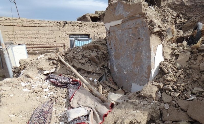
Over the weekend, a M=5.8 earthquake struck the North Khorasan province in northeast Iran, near the border with Turkmenistan, leaving at least three people dead, and hundreds more injured. The quake hit at 10:31 p.m. local time on Saturday (13 May), and shaking caused extensive damage in several villages close to the epicenter. Based on data from the USGS, the quake occurred at a depth of 12.5 km, and resulted in very strong shaking in the immediate vicinity of the epicenter. While this level of ground shaking is strong enough to result in damage, because the majority of structures in this region of Iran are masonry and not capable of withstanding strong shaking, many buildings collapsed. According to the head of the local rescue and relief organization, 14 villages experienced up to 70% damage.
Even though the USGS does not have a focal mechanism, based on the regional tectonics and surrounding geology, this quake likely originated on a strike-slip or thrust fault. It is unlikely to be a normal faulting event as this would require an extensional environment, which is not in line with plate motion vectors. Much of the compression in this portion of the Middle East is due to the slow movement of the Arabian Peninsula northward. Across all of Iran, compression has resulted in the formation of the Zagros Mountains in the south, and fold and thrust belts in the north.

Unfortunately, in the region around Saturday’s quake there are no surface faults in the area. However, the spectacularly-dipping bedding, which is clearly visible in the Google Earth image above further illustrates the region’s compressional regime. The bedding, which in this image dips to the south was initially horizontal. However, due to massive amounts of compression, the bedding has been tilted to the point where it is now nearly vertical.
Based on the Global Earthquake Activity Rate (GEAR) model, which is available in Temblor, we can see if the earthquake over the weekend was surprising or not. This model uses global strain rates and seismicity to forecast the likely earthquake magnitude in your lifetime anywhere on earth. In the figure below, we can see that in the region around Saturday’s earthquake, a M=6.25+ event is possible. Such a quake would likely cause significant damage, especially given how many buildings were destroyed in the weekend’s event.

References
USGS
Al Jazeera
Tehran Times
- Earthquake science illuminates landslide behavior - June 13, 2025
- Destruction and Transformation: Lessons learned from the 2015 Gorkha, Nepal, earthquake - April 25, 2025
- Knock, knock, knocking on your door – the Julian earthquake in southern California issues reminder to be prepared - April 24, 2025