By David Jacobson, Temblor
Check if you are in a liquefaction zone in Temblor
New satellite imagery reveals sinking Millennium Tower

While most high-rise buildings in modern cities are symbols of prosperity, strength, and transformation, the Millennium Tower represents a headache. New findings by an independent contractor discovered that since the building’s completion in 2009, it has sunk 16 inches and tilted two inches to the northwest. While this is alarming and exceeded expectations of builders, it is not necessarily unexpected, given the building’s location. One of the possible factors, in addition to normal settlement, which could have influenced the building’s subsidence, is the soil itself and the liquefaction susceptibility of the area.

The Millennium Tower (blue pin in the Temblor map above) is in an area of ‘Very High’ liquefaction susceptibility. This category is often reserved for man-made fill, which is what the Millennium Tower rests on. Man-made fill is highly susceptible to liquefaction because it is unconsolidated, young, and in the case of San Francisco, was placed in areas that were once submerged bay floor. This means the area could be saturated the majority of the time. Furthermore, highly liquefiable soil can become unstable if it experiences changes in loading, such as when a large building is erected.
According to reports in the San Francisco Chronicle, to cut costs, the Millennium Tower was anchored using a concrete slab and 80 foot piles into dense sand, rather than into bedrock 200 feet deep. Additionally, the Millennium Tower is made of concrete, which is very heavy. Combine this with the man-made fill surrounding the building and you have a potential problem.
If you put a very heavy object on soil that is potentially saturated and isn’t consolidated, it will move due to a loss of shear strength. However, anchor it to a fixed object, and it is likely that very little to no subsidence or tilting will occur. Because of these factors, it is not necessarily surprising that the building has sunk more than builders expected. Additionally, even though the Millennium Tower was awarded the Structural Engineering Project of the Year in California in 2008, and an award of merit in structural engineering in 2009, the situation illustrates the challenges associated with living and building on unstable ground.
The sinking and tilting occurring at the Millennium Tower also provides a parallel to the effects of liquefaction during an earthquake. Thousands of buildings in Christchurch suffered this fate in 2011 and had to be torn down. Using Temblor, you can check the liquefaction susceptibility at your home or office to see what your risks are.
Why does the ground liquefy?
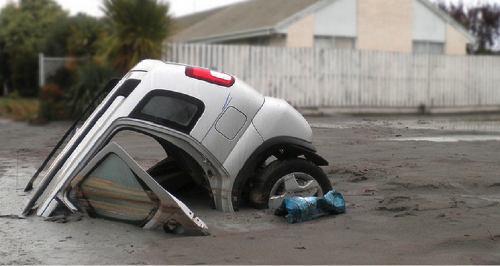
Most people tend to focus on the obvious effects of liquefaction following an earthquake. This is understandable as they can be widespread and, as the photo below shows, quite dramatic. However, it is also important to understand why, when an earthquake happens, the ground can turn into a slurry.

The first questions to ask is, when does liquefaction occur? While the straightforward answer is, during earthquakes, this is far too simplistic, as it could imply liquefaction takes place in all earthquakes. Fortunately, it does not, which means more explanation must be given.
For liquefaction to occur, a certain level of ground shaking must be reached. This measurement, termed peak ground acceleration (PGA), is recorded as a percentage of gravitational acceleration. While triggering thresholds vary around the world, in Christchurch, a PGA of 10-20% was needed to cause liquefaction. To produce these levels of shaking, earthquake magnitudes exceeding 5.2 were necessary. (In the February 22, 2011 M=6.3 earthquake, PGA readings reached 220%, the second highest ever recorded).

While this information helps explain when liquefaction occurs, it does not shed light on how it happens. When a fault ruptures, seismic waves travel through the ground. These waves not only influence the shaking we feel, but the properties of the ground we stand on. In water-saturated sediment, seismic waves result in increased water pressure, causing individual grains of sediment to lose contact with one another. When this happens, the sediment loses strength and behaves like a liquid.
What are the effects of liquefaction?
When a liquefiable layer loses cohesion, and behaves like a liquid, the effects can be dramatic. Some of the more common effects include:
Lateral Spreading: The ground can slide down shallow slopes, often due to a non-liquefiable sediment layer resting on top of a liquefiable layer. When this happens, large cracks can open up as the non-liquefiable layer is torn apart.

Sand Blows: A buried liquefiable layer can be forced upward due to pressure, causing it to erupt at the surface.

Subsidence : In some areas, liquefaction can cause the ground to sink permanently. This effect can be localized or even regional.

Can liquefaction happen everywhere?
A final question to ask is where does liquefaction happen? For sediment to liquefy, it needs to be saturated, loose, and granular. Some of the sediments that meet these criteria are man-made land, as well as sandy beach and stream deposits. For sediments to be loose, they must be “young,” a term that to geologists means less than 11,000 years old. While this age is not a requirement, younger sediments are more susceptible to experiencing liquefaction, as they are likely less consolidated.
When all of this is put together, it’s clear that liquefaction is extremely site-specific. If not all of the criteria are met, liquefaction will not occur. However, even if all criteria are met, it does not mean that liquefaction will definitely happen. Therefore, certain areas are more susceptible. Experts can determine liquefaction susceptibility by analyzing the surface geology, geomorphology, and depth to groundwater (which influences the likelihood that sediment will be saturated). This type of information is what is displayed in Temblor liquefaction maps .
Sources
Bastin, S., Bassett, K., Quigley, M., Maurer, B., Green, R.A., Bradley, B., Jacobson, D., (2016) Late Holocene liquefaction at sites of contemporary liquefaction during the 2010-2011 Canterbury Earthquake Sequence, New Zealand, Bulletin of the Seismological Society of America, doi: BSSA-D-15-00166.
Bastin, S., Quigley, M.C., Bassett, K. (2015) Comparison of liquefaction-induced land damage and geomorphic variability in Avonside, New Zealand, 6th International Conference on Earthquake Geotechnical Engineering, 1-4 November 2015, Christchurch, New Zealand.
Bastin, S., Quigley, M., and Bassett, K. (2015) Paleoliquefaction in Christchurch, New Zealand, GSA Bulletin, B31174-1.
Hughes, M., Quigley, M., van Ballegooy, S., Deam, B., Bradley, B, Hart, D., Measures, R. (2015) The sinking city: Earthquakes increase flood hazard in Christchurch, New Zealand, GSA Today 25, 3, 4-10.
Knudsen, Keith J., Sowers, Janet M., Witter, Robert C., Wentworth, Carl M., Helley, Edward J. (2000) Preliminary Maps of Quaternary Deposits and Liquefaction Susceptibility, Nine-County San Francisco Bay Region, California: A Digital Database, U.S. Geological Survey.
Quigley, M., Bastin, S., and Bradley, B., (2013) Recurrent liquefaction in Christchurch, New Zealand during the Canterbury earthquake sequence, Geology 41 (4) p. 419-422.
http://www.sfchronicle.com/bayarea/article/SF-s-landmark-tower-for-rich-and-famous-is-8896563.php
http://sf.curbed.com/2016/8/1/12341914/millennium-tower-sinking
http://www.de-simone.com/projects/project/millennium-tower/
http://www.handelarchitects.com/projects/project-main/millennium-tower-main.html
Check if you are in a liquefaction zone in Temblor
Related Blog
New satellite imagery reveals sinking Millennium Tower

- Deep earthquake beneath Taiwan reveals the hidden power of the Ryukyu Subduction Zone - January 7, 2026
- Magnitude 7 Yukon-Alaska earthquake strikes on the recently discovered Connector Fault - December 8, 2025
- Upgrading Tsunami Warning Systems for Faster and More Accurate Alerts - September 26, 2025
