By David Jacobson, Temblor

It’s now been a little over four days since Mexico’s Chiapas region was struck by a deadly M=8.1 earthquake. As the region begins the cleanup from the largest earthquake to hit the country in over a century, we can now take a closer look at the dynamics of this event, and address that while it was extremely destructive, it could have been much worse.

Earthquake dynamics
As we reported immediately after the earthquake, despite the fact that the epicenter of the quake was close to the Middle America Trench, where the Cocos Plate subducts beneath the North American Plate, this was not a megathrust (compressional) event. Instead, the USGS focal mechanism shows it as extensional. Furthermore, the earthquake on Thursday is what is known as a intraplate event, meaning it did not occur on a plate boundary. We know this both because of the focal mechanism, and because of the earthquake’s depth. At 70 km depth, this earthquake ruptured approximately 40 km below the subduction zone surface, based on the Slab 1.0 model produced by Dr. Gavin Hayes at the USGS. The cross section below, provided by Dr. Hayes, shows the location of Thursday’s earthquake relative to the subducting surface.

Even though this earthquake did not occur on the subduction zone, it has not been completely quiet according to Dr. Hayes. He said that because “some of the aftershocks are thrusts (compressional), presumably the mainshock has triggered at least some megathrust activity. What happens next is of interest, of course.” One of the reasons for this is because this quake occurred near the Tehuantepec Gap, a region that has been seismically inactive for the last century. While it is not yet known if this quake relieved stress in the area, it does deserve close attention. Furthermore, this subduction zone is of great interest and concern because had a similar earthquake occurred along the megathrust, the consequences likely would have been much greater. In short, 40 km could have saved many lives and infrastructure.
It could have been worse
Because the M=8.1 earthquake on Thursday occurred at a depth of 70 km, rather than at 30 km along the subduction zone surface, the seismic waves had to travel a greater distance before reaching the surface. In the process, they would have lost a significant amount of energy. Therefore, even though violent shaking was experienced offshore close to the epicenter, no one on land was exposed to these levels. This likely would not have been the case with a shallower quake, which could have triggered more landslides and building collapse, both of which can greatly contribute to loss of life. In addition to the fact that a different depth could have resulted in greater losses, it is also important to point out that had this quake occurred northwest or southeast, results could have been catastrophic as then the cities of Mexico City and Guatemala City would have been exposed to much more serious shaking.

While any loss of life is too much in a natural disaster, immediately following the earthquake, the prognosis looked grim. The USGS PAGER system, an automated system that produces earthquake impact estimates, upgraded its initial assessment of “orange,” suggesting there will likely be 100-1,000 fatalities, to “red” (1,000-10,000). Furthermore, estimated economic losses were significantly increased. Dr. Kristin Marano at the USGS, who is involved with the PAGER system said that this “shift in PAGER loss estimates between version 1 and 2 were due to a large increase in the population exposed to higher ground motions as estimated by ShakeMap using the updated origin information.” In the figure below, the original and current ShakeMaps are shown, with the most notable difference being warmer colors along the coast.
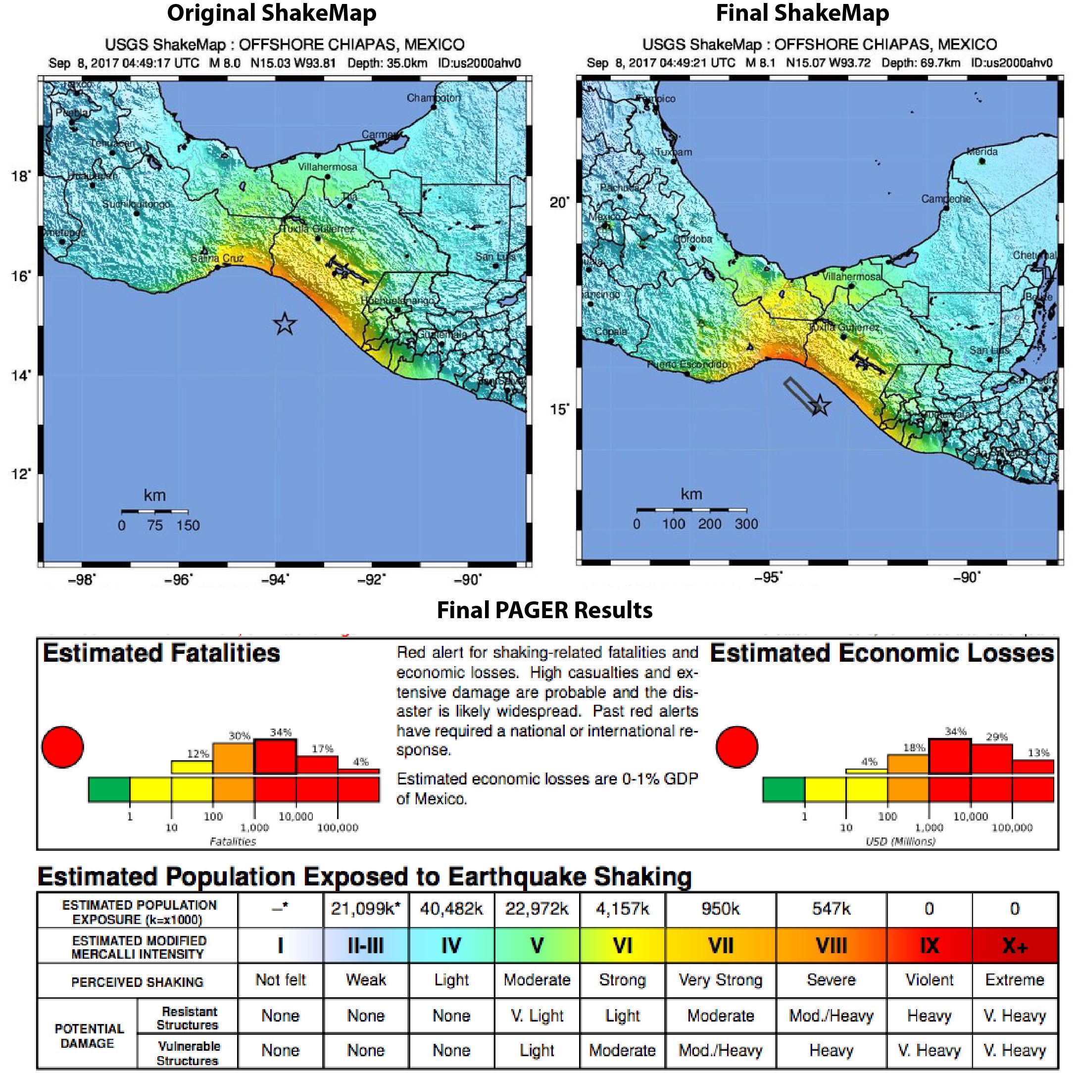
Fortunately, in this earthquake, there were far fewer fatalities than what was projected. As of today, there are fewer than 100 fatalities, most of which were in small communities along the coast where the greatest shaking was experienced. While this number will likely rise a bit, as more people are found, one could potentially say that Mexico dodged a bullet in terms of what could have happened.
References
USGS
European-Mediterranean Seismological Centre (EMSC)
Personal Communication with Dr. Gavin Hayes (USGS)
Personal Communication with Dr. Kristin Marano (USGS)
- Earthquake science illuminates landslide behavior - June 13, 2025
- Destruction and Transformation: Lessons learned from the 2015 Gorkha, Nepal, earthquake - April 25, 2025
- Knock, knock, knocking on your door – the Julian earthquake in southern California issues reminder to be prepared - April 24, 2025