By David Jacobson, Temblor

Over the last two days, a series of earthquakes has struck the Aleutian Islands in Alaska near Adak Island. Approximately 8 hours ago, there was a M=5.9, and two days ago, a M=6.4 struck. While almost no one lives along this portion of the archipelago, the recent swarm highlights a zone where the plate boundary transitions from pure subduction to strike-slip motion. What this means is that in the area of the recent earthquakes, there is oblique subduction and earthquakes with varying focal mechanisms can occur.
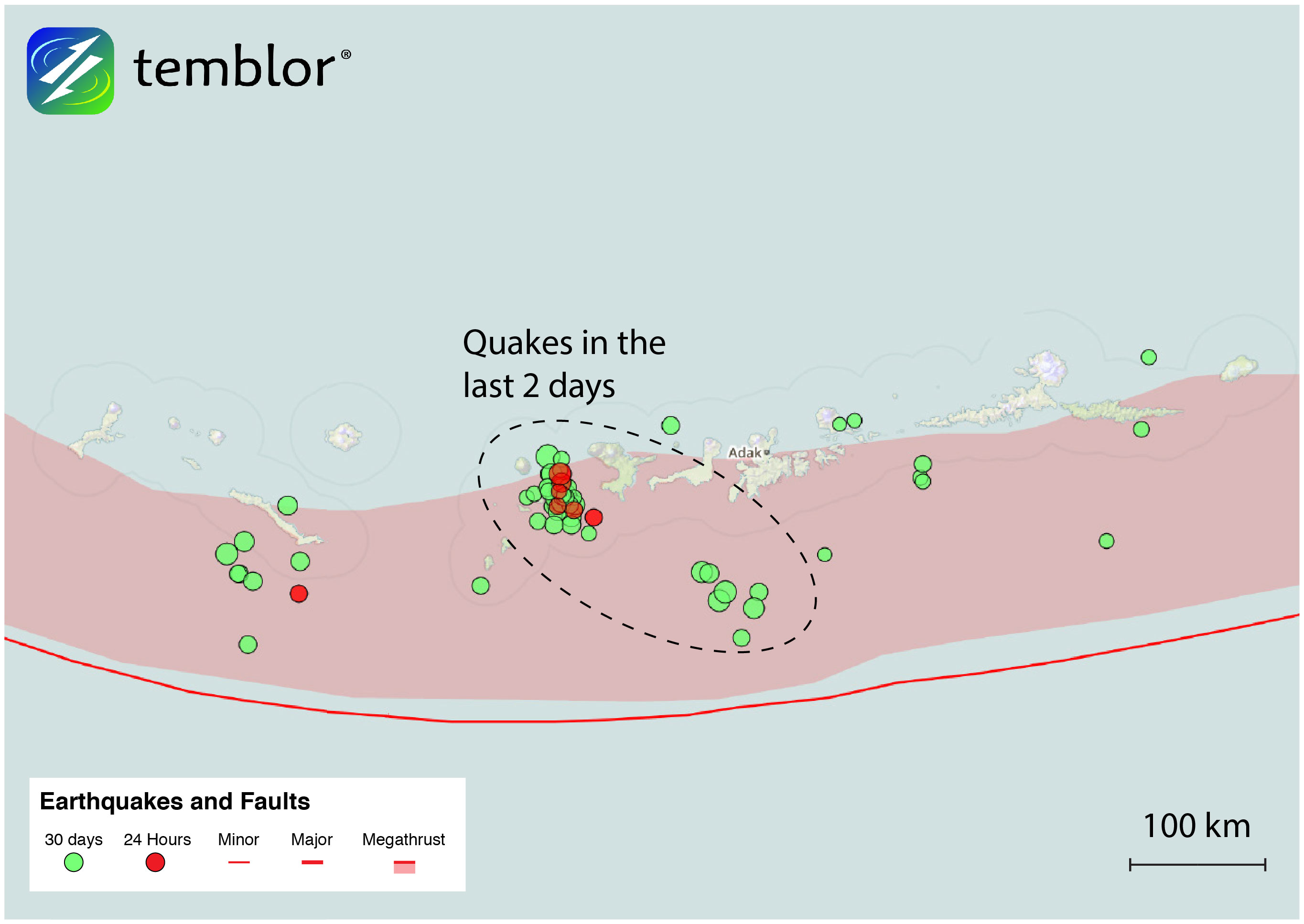
The Aleutian arc stretches for over 3,000 km from the Gulf of Alaska to the Kamchatka Peninsula in Russia. The arc formed as a result of subduction of the Pacific plate beneath the North American plate. In addition to large earthquakes along the Aleutian Trench, volcanism is extremely common, including eruptions this year. Because of the distance the Aleutians cover, and how the curvature of the arc influences tectonic activity, it is broken up into three regions (west, central, and east). Moving from east to west, plate convergence increases from around 60 mm/yr to nearly 80 mm/yr. The recent earthquakes occurred in the central region, which we will give greater focus to.
Within the central Aleutians, plate convergence is approximately 73 mm/yr. As is evident from the map below, subduction is taking place at an oblique angle. Compare this to the areas west and east where motion is nearly pure strike-slip and subduction respectively. This has profound effects on the type of earthquakes that can occur. Based on other earthquakes with the same depth in the surrounding area, today’s earthquake likely had a strike-slip focal mechanism. However, 100 km to the southeast, earthquakes have a nearly pure thrust focal mechanism, illustrating the dynamic tectonic environment of the central Aleutians, where both subduction zone and shallow crustal earthquakes can occur.
While the earthquakes in recent days have not been large enough to cause damage or disruption, this part of the Aleutians is no stranger to large earthquakes. In 1957, the M=8.7 Andreanof Islands earthquake to the southeast of Adak Island resulted in $5 million in damages to the island, and a local tsunami. In fact, the earthquakes in the last two days, have taken place in the aftershock zone of the 1957 quake, according to the USGS.

Because of the significant strain built up from oblique subduction, this part of Alaska is susceptible to larger earthquakes than anywhere else in the state. Based on the Global Earthquake Activity Rate (GEAR) model, which is available in Temblor, the central Aleutians is likely to see a M=7.5+ earthquake in your lifetime. Additionally, based on the slip deficit in the region, an event similar to the M=8.6 in 1957 is possible. Therefore, while the recent earthquake should not be seen as surprising, they definitely need to be monitored. To view the GEAR model, click here.
Reference
USGS
- Earthquake science illuminates landslide behavior - June 13, 2025
- Destruction and Transformation: Lessons learned from the 2015 Gorkha, Nepal, earthquake - April 25, 2025
- Knock, knock, knocking on your door – the Julian earthquake in southern California issues reminder to be prepared - April 24, 2025