By David Jacobson, Temblor
Updated: 22 March 2017 (10 a.m.)

Almost three weeks ago, a seismic swarm just west of the city of Seattle, Washington, and southwest of Bainbridge Island started. It began with a M=3.3, which was followed a week later by a M=3.4 and a M=3.5. In total, the USGS has recorded 91 earthquakes in the area over the last 2.5 weeks. While the swarm is not as active as it was a couple weeks ago, only two earthquakes in the last day, we thought we’d take a look at the activity and the regional tectonics, with help from the people at the Pacific Northwest Seismic Network.

The city of Seattle sits right on top of the Seattle Fault zone, an east-west-striking system of reverse faults within the Puget Lowland. While active, the Seattle Fault Zone is largely concealed as it lies at the southern end of the Seattle Basin, which is covered by surface deposits, water and dense vegetation. Nonetheless, by using LiDAR (light detection and ranging) the faults can be clearly seen (See image below). This complex system of reverse faults formed due to regional compression on the order of 0.5 cm/yr.

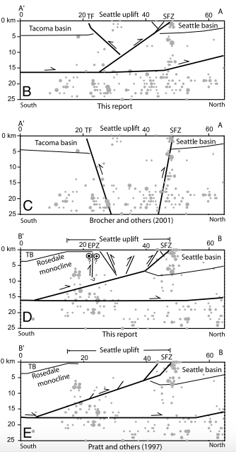
While based exclusively on location, the recent swarm appears to have occurred on the Seattle Fault Zone, there are several characteristics suggesting otherwise. First, while the Seattle Fault Zone is oriented almost perfectly east-west, the swarm trends northeast-southwest, suggesting an alternative structure. Additionally, Renate Hartog, a research scientist at the Pacific Northwest Seismic Network, pointed out in a blog post that the quakes may be occurring beneath the Seattle Fault Zone. The figure below shows schematic maps of how the Seattle Fault Zone may behave at depth. With the exception of diagram ‘C,’ all diagrams show the fault not reaching depths below 17 km. Nearly all the earthquakes in the recent swarm occurred at depths greater than this, and focal mechanisms show dips shallower than that depicted in diagram ‘C.’ It should also be pointed out that the focal mechanisms show that these quakes are thrust events consistent with north-south compression. What all of this suggests is that the recent swarm likely took place beneath the Seattle Fault Zone. However, it is possible that the quakes occurred on structures associated with the Seattle Fault Zone.
In addition to looking at the earthquakes spatially, we can also look at a time series to see how the swarm is behaving. In the graph below, produced by the Pacific Northwest Seismic Network, earthquakes from the beginning of the swarm through yesterday (21 May 2017) are shown. In a typical mainshock-aftershock sequence, the frequency (not magnitude) of aftershock occurrence rapidly decreases. However, in this sequence, the frequency is roughly the same, which is why it is considered a swarm. It should be pointed out that swarms can last for varying amounts of time (in some cases years) and do not necessarily indicate that larger earthquakes will happen. However, in some cases they can preclude greater magnitude events. Therefore, they are and should be carefully monitored.

Even though these quakes likely did not occur on the Seattle Fault Zone, because of the threat it poses to the city of Seattle it merits greater discussion. Based on research by Robert Bucknam, Gordon Jacoby, Brian Atwater, and others, the Seattle Fault is responsible for a M=7.0 earthquake approximately 1,100 years ago, This quake caused uplift, landslides, and even a local tsunami in Puget Sound. While 1,100 years ago is a long time ago, based on the amount of strain which could have accumulated, a M=6.8 is possible. Such an event would have extreme effects on the area, with many people citing the devastating 2011 M=6.3 Christchurch, New Zealand earthquake as an example of what things could be like the next time the Seattle Fault ruptures. Further suggesting a Christchuch-like earthquake is possible in the Seattle area is that the Global Earthquake Activity Rate (GEAR) model, which is available in Temblor, shows that the area within 50 km of the recent swarm is likely to experience a M=6.25+ earthquake in your lifetime. This model does not take faults into account and only considers global strain and historical seismicity. What all of this shows is that there is a significant seismic threat to the region and it must be acknowledged and understood.

References
Renate Hartog (Pacific Northwest Seismic Network) Blog titled “Earthquake swarm NE of Bremerton” – Link
Pacific Northwest Sewismic Network
USGS
Samuel Y. Johnson, Richard J. Blakely, William J. Stephenson, Shawn V. Dadisman, and Michael A. Fisher, Active shortening of the Cascadia forearc and implications for seismic hazards of the Puget Lowland, TECTONICS, VOL. 23, TC1011, doi:10.1029/2003TC001507, 2004
Richard J. Blakely, Ray E. Wells, Craig S. Weaver, Samuel Y. Johnson, Location, structure, and seismicity of the Seattle fault zone, Washington: Evidence from aeromagnetic anomalies, geologic mapping, and seismic-reflection data, GSA Bulletin; January 2002; v. 114; no. 1; p. 169–177.
- Earthquake science illuminates landslide behavior - June 13, 2025
- Destruction and Transformation: Lessons learned from the 2015 Gorkha, Nepal, earthquake - April 25, 2025
- Knock, knock, knocking on your door – the Julian earthquake in southern California issues reminder to be prepared - April 24, 2025