Despite being deeply seated, a magnitude 7.0 earthquake beneath Taiwan was widely felt. Like other previous strong, deep earthquakes in the region, which caused damage at the surface, this event demonstrates that even deep quakes can produce severe surface impacts, underscoring the persistent seismic hazard associated with the Ryukyu Subduction Zone.
By Chung-Han Chan, Earthquake-Disaster & Risk Evaluation and Management (E-DREaM) Center, National Central University, Taoyuan, Taiwan
Citation: Chan, C.-H., 2026, Deep earthquake beneath Taiwan reveals the hidden power of the Ryukyu Subduction Zone, Temblor, http://doi.org/10.32858/temblor.371
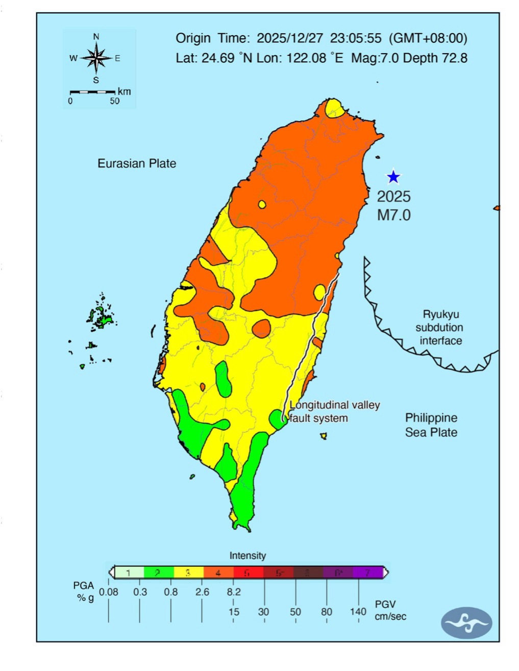
On December 27, 2025, a magnitude 7.0 earthquake struck about 32 kilometers offshore eastern Taiwan, generating widespread shaking across much of the island. Although the epicenter was located nearly 70 kilometers beneath the surface, the earthquake was felt broadly, underscoring that some of Taiwan’s most impactful seismic events originate deep within the subducting plate rather than at shallow crustal depths. Fortunately, there was minimal damage and no reported deaths.
This event occurred within the Ryukyu subduction system, where the Philippine Sea Plate dives beneath the Eurasian Plate. Unlike shallow crustal earthquakes, which often cause localized but intense damage, deep earthquakes in subduction zones can transmit seismic energy over long distances, producing widespread shaking even when the epicenter is far offshore.
A deep earthquake with far-reaching effects
According to the Central Weather Administration, Taiwan’s official agency for earthquake monitoring, the earthquake occurred at a depth of approximately 73 kilometers (about 45 miles), placing it within the subducting Philippine Sea Plate. Earthquakes at this depth are classified as intraslab events and typically do not rupture the Earth’s surface. Nevertheless, they can produce widespread and sometimes intense ground shaking, because seismic waves propagate efficiently through the cold, high-velocity slab (Chen et al., 2013).
Instrumental records across Taiwan (Figure 1) confirmed this behavior. Despite the epicenter being offshore, ground motions were widely recorded across northern and central Taiwan. This pattern reflects a well-known phenomenon in the Ryukyu Subduction Zone: Seismic energy becomes channeled along the descending plate, producing elongated zones of strong shaking rather than the more circular, bullseye-shaped patterns typically observed in shallow crustal earthquakes, centered on the epicenter. The descending plate functions as a waveguide as it channelizes the seismic waves, which means that the waves are efficiently transported with minimal attenuation.
Why the Ryukyu Subduction Zone matters
The Ryukyu subduction system, extending from southwestern Japan to northeastern Taiwan, is one of the most seismically active plate boundaries in the western Pacific. Historical and instrumental records show that this region has repeatedly generated deep and damaging earthquakes, including the 1909 Taipei earthquake (M ~7.3), which despite being 75 km deep, caused widespread destruction in northern Taiwan and remains one of the most significant seismic events in the region’s recorded history (Kanamori et al., 2012; Liao et al., 2016). Together, these observations underscore the persistent seismic hazard associated with the Ryukyu Subduction Zone and highlight the importance of continued monitoring, improved hazard modeling, and sustained international collaboration to better understand and mitigate earthquake risks in this tectonically active region.
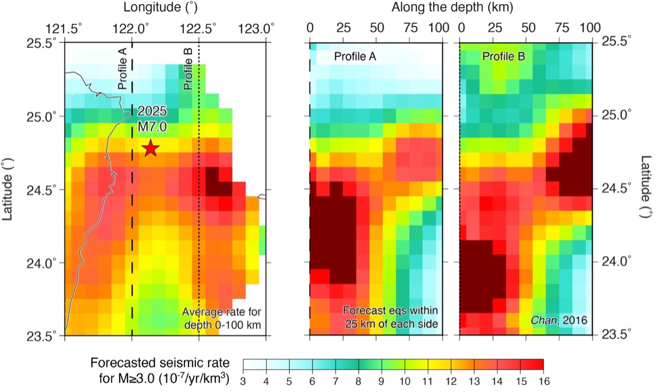
Recent three-dimensional seismicity models and comprehensive earthquake catalogs indicate that the 2025 earthquake’s location within the subducting slab is particularly efficient at generating seismic energy (Chan, 2016). The pronounced ground shaking observed in Taiwan during subduction intraslab events is partly attributed to waveguide effects within the subducting slab.
What seismic hazard models tell us
Recent updates to the Taiwan Earthquake Model (TEM) and related probabilistic seismic hazard assessments (Gao et al., 2025) show that this region has one of the highest rates of intermediate-depth seismicity in the western Pacific (Figure 3). The b-value describes the relative proportion of small to large earthquakes; a b-value of 0.87 for the Ryukyu subduction system indicates a comparatively higher likelihood of larger-magnitude events than typically observed in global subduction zones. The a-values, assigned to individual along-strike and depth-dependent segments of a fault, quantify seismic productivity and reveal pronounced spatial heterogeneity in earthquake occurrence rates across intraslab sources. According to the latest modeling:
• Earthquakes of magnitude ~7 in this segment have recurrence intervals on the order of 10 to 20 years.
• Larger events approaching magnitude 7.5 remain plausible on longer timescales.
• Hazard maps consistently highlight northeastern Taiwan as a zone of elevated shaking potential, even for events originating offshore.

Why this matters for Taiwan
Although deep earthquakes rarely produce surface rupture, their ability to generate widespread and sometimes intense ground shaking poses significant challenges for infrastructure, emergency response, and public preparedness. Critical facilities—including densely populated urban areas and high-tech or precision industries—can be affected even when the epicenter lies far offshore. Accurately assessing these risks requires high-quality earthquake catalogs and well-constrained subduction-zone models that capture the geometry, seismicity, and recurrence behavior of deep plate-boundary systems.
The need to obtain a high-quality earthquake database highlights the importance of sustained cross-border scientific collaboration. Because the Ryukyu Subduction Zone lies largely offshore of Taiwan, earthquake catalogs compiled solely by the Central Weather Administration may be incomplete, particularly with respect to offshore seismicity. The research discussed here is supported by the Japan-Taiwan Exchange Association, which serves as Japan’s de facto embassy in Taiwan and plays a vital role in enabling bilateral scientific cooperation. Through the Japan-Taiwan Exchange Association, researchers from Taiwan and Japan have worked together to integrate earthquake catalogs, harmonize seismic observations, and refine seismic hazard models for the Ryukyu subduction system. Such collaboration is essential for improving the quality of subduction-zone databases, advancing seismic hazard assessments, and ultimately strengthening regional resilience to future large earthquakes.
Looking ahead
This earthquake is a reminder that seismic hazard in Taiwan is not confined to shallow crustal faults. The Earth’s deeper structure plays an equally important role in shaping the island’s seismic risk. Ongoing research — combining dense seismic observations, improved hazard modeling, and international collaboration — will be crucial for refining forecasts and strengthening disaster preparedness.
As scientists continue to unravel the complex behavior of the Ryukyu subduction system, events like the December earthquake provide valuable data, helping transform each earthquake into a better understanding of the next one.
References
Chen, K. H., Kennett, B. L., & Furumura, T. 2013. High‐frequency waves guided by the subducted plates underneath Taiwan and their association with seismic intensity anomalies. Journal of Geophysical Research: Solid Earth, 118(2), 665-680. https://agupubs.onlinelibrary.wiley.com/doi/full/10.1002/jgrb.50071.
Gao, J. C., Kao, J. C., Chan, C. H., Chuang, R. Y., Chen, C. H., Shyu, J. B. H., … & Ma, K. F. 2025. Probabilistic Seismic Hazard Assessment for Taiwan: Updates and Improvements in TEM PSHA2025. Preprint available at SSRN: http://dx.doi.org/10.2139/ssrn.5736969.
Kanamori, H., Lee, W. H., & Ma, K. F. 2012. The 1909 Taipei earthquake—implication for seismic hazard in Taipei. Geophysical Journal International, 191(1), 126-146. https://onlinelibrary.wiley.com/doi/abs/10.1111/j.1365-246X.2012.05589.x.
Liao, Y. W., Yen, Y. T., Lee, S. J., & Ma, K. F. 2016. 1909 Taipei earthquake ground motion simulation. Terr. Atmos. Ocean. Sci., 27, 415, 430. https://scholars.ncu.edu.tw/zh/publications/1909-taipei-earthquake-ground-motion-simulation/.
Copyright
Text © 2026 Temblor. CC BY-NC-ND 4.0
We publish our work — articles and maps made by Temblor — under a Creative Commons Attribution-NonCommercial-NoDerivatives 4.0 International (CC BY-NC-ND 4.0) license.
For more information, please see our Republishing Guidelines or reach out to news@temblor.net with any questions.
- When Tokyo’s next big earthquake hits, could global markets crash? - March 20, 2026
- The Earthquake that Shook the South - February 26, 2026
- Introducing Coulomb 4.0: Enhanced stress interaction and deformation software for research and teaching - February 20, 2026