Temblor Insight|Mar 29, 2016
The M=4.2 shock, and a M=4.1 aftershock 5 hr 26 min later, struck just 45 miles north of Oklahoma City, between the West Lawrie and Sooner Trend oil fields. The M=4.2 shock was felt in Oklahoma City, Tulsa, and Wichita, Kansas. The earthquake depths are shallow, but currently uncertain (4-5 km depth with an uncertainty of about the same extent). The quake location and depth are consistent with being induced by deep reinjection of ‘produced water’ or oil and gas field waste water.

The sense of motion (‘focal mechanism’) of the M=4.2 quake suggests either left-lateral slip on the 25-mile (40-km) long east-west fault, or right lateral motion on the north-south fault, with the former more likely based on the earthquake locations (their uncertainty is about ±0.6 mi or 1.1 km). The Oklahoma fault map comes from the Oklahoma Geological Survey (2015); it’s an extension of Holland (2013) and is based on focal mechanisms, which are less certain than a map based on surface mapping. Nevertheless, the inferred 25-mi long east-west fault means there is a possibility of a larger rupture, up to M~6.2. The north-south fault is considerably longer, and cuts through Oklahoma City.
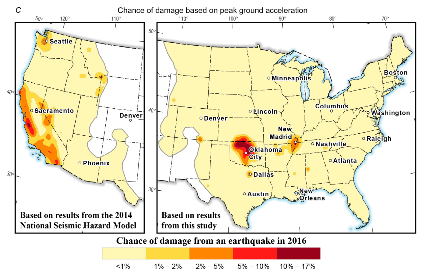
Mark Petersen et al. have just published the first USGS seismic hazard assessment of the ‘oil patch,’ the areas of Oklahoma, Kansas, Texas, Arkansas, and Colorado where induced earthquakes have become common over the past decade. Unlike natural or ‘tectonic’ quakes, the rates of induced earthquakes are highly sensitive to the reinjection volumes and pressures, and so cannot be accurately forecast without knowledge of the realtime injection well activity. So, instead the USGS assessment uses the past 1-2 years of seismicity to make a one-year forecast for 2016. To assess the hazard, one also has to assume an upper earthquake magnitude, which is of course quite uncertain because the record of induced quakes is only about 15 years long. Peterson et al. used M-max = 7.1, which strikes us as reasonable and prudent. The results show the dramatic impact of induced seismicity on hazard and the potential of damage.
Central Oklahoma surpasses California in the annual chance of damage, and has a large region with more than a 1 in 10 chance of damage. Oklahoma City and Dallas also stand out as particularly vulnerable to seismic damage, followed by greater Los Angeles, the San Francisco Bay area, and Seattle in the West, and by New Madrid in the central US, site of several enigmatic M~7 tectonic quakes in 1811-1812 and a high rate of small shocks today.
We will now work to incorporate the new USGS hazard assessment into the Temblor seismic hazard rank and damage estimates, so that people in the oil patch can assess their seismic risk and consider ways to reduce it, including retrofit and insurance.
Ross Stein and Volkan Sevilgen, Temblor
Data from USGS; Oklahoma Geological Survey; and Mark D. Petersen, Charles S. Mueller, Morgan P. Moschetti, Susan M. Hoover, Andrea L. Llenos, William L. Ellsworth, Andrew J. Michael, Justin L. Rubinstein, Arthur F. McGarr, and Kenneth S. Rukstales, 2016 One-Year Seismic Hazard Forecast for the Central and Eastern United States from Induced and Natural Earthquakes, U.S. Geol. Surv. Open-File Rep. 2016–1035; and McNamara, D.E., HM Benz, R.B. Herrmann, E.A. Bergman, P. Earle, A. Holland, R. Baldwin, and A. Gassner (2015), Earthquake hypocenters and focal mechanisms in central Oklahoma reveal a complex system of reactivated subsurface strike-slip faulting. Geophys. Res. Lett., 42, 2742–2749. doi: 10.1002/2014GL062730; Austin A. Holland (2013) Optimal fault orientations within Oklahoma, Seismol. Res. Lett., 84, 876-890, doi: 10.1785/0220120153.
- Earthquake science illuminates landslide behavior - June 13, 2025
- Destruction and Transformation: Lessons learned from the 2015 Gorkha, Nepal, earthquake - April 25, 2025
- Knock, knock, knocking on your door – the Julian earthquake in southern California issues reminder to be prepared - April 24, 2025