by Gabriel Lotto and Ross Stein, Temblor
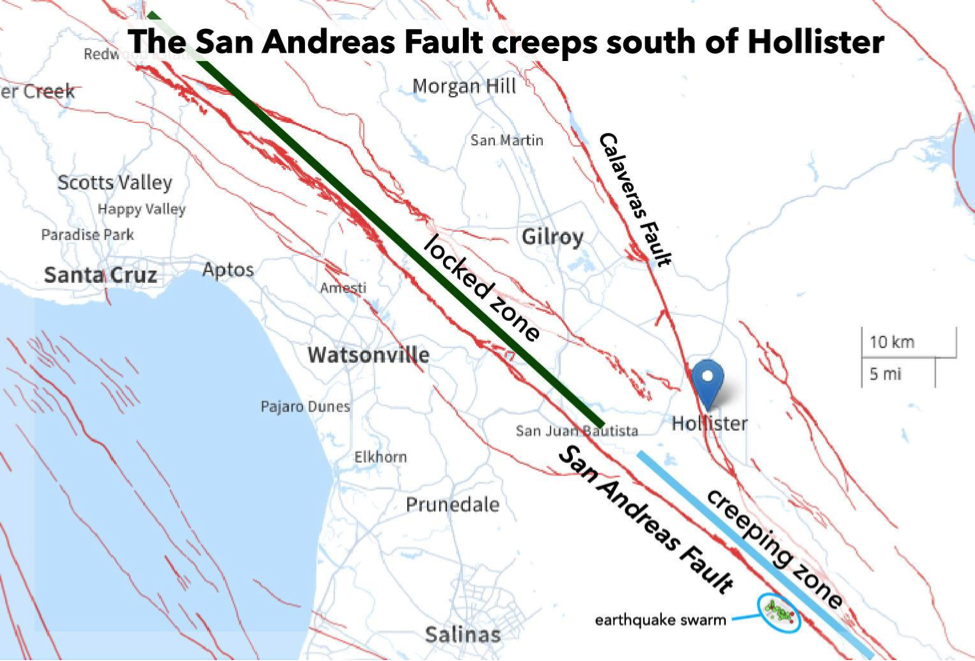
Does the name “Hollister” conjure up visions of surf-lifestyle clothing for landlocked teenagers? If so, it’s time to forget everything you know about Hollister. The real Hollister, CA, is a small city 65 km southeast of San Jose that sits atop the Calaveras Fault and only a few kilometers from the San Andreas Fault, a good place to surf seismic waves. But Hollister has been in the news recently because of an earthquake swarm that started on July 17.

What is an earthquake swarm?
An earthquake swarm is a series of small earthquakes that occur roughly in the same place and same time. This swarm, 25 km (15 mi) south of Hollister, lasted for just a couple of days and extended over a 3-km-long linear region. One question you might ask: why isn’t this earthquake swarm located on the San Andreas Fault? Actually, it probably is, because the San Andreas is inclined slightly to the southwest. The largest event in the earthquake swarm, a M=4.2 temblor, caused mild shaking for thousands of people from San Jose to Salinas.

What does the earthquake swarm tell us about Hollister’s risk?
The earthquake swarm occurred where the San Andreas Fault transitions from a zone to the north that is fully ‘locked,’ and a zone to the south that is fully ‘creeping.’ The locked zone, extending north from San Juan Bautista, builds up stress over decades and releases that stress in large earthquakes like the 1906 event that demolished San Francisco. The creeping zone, extending from just south of San Juan Bautista to Parkfield in central California, is a better place to be: Creeping faults continuously slide against each other at a speed of millimeters per year, often accompanied by a staccato chattering of small shocks. The creeping section does not accumulate stress and so cannot host large earthquakes. Instead, the fault here is lubricated by slippery minerals like serpentinite and talc, the same mineral that makes your armpit slippery when you use talcum powder.
Why, then, did these small earthquakes take place on an ostensibly creeping section of the San Andreas? The stress on faults has many spikes and saddles. Little quakes happen all the time, knocking down the spikes and filling in the saddles. So, there is no reason to believe that the area south of Hollister is at any increased risk of a large earthquake. Still, Hollister and nearby San Juan Bautista are located in the armpit (no, this is not a technical term, but we like it anyway) of the San Andreas Fault and the Calaveras Fault, both of which can host moderate and large earthquakes. So, the level of seismic hazard from nearby quakes is, and always has been, significant.
Bonus: A stream channel reveals the awesome power of the San Andreas
In our investigation into the Hollister earthquake swarm, we noticed a cool feature familiar to geology students everywhere: an offset stream.

The San Andreas is a ‘right-lateral’ fault, which means that if you’re standing on one side of the fault, the other side moves to the right. You can see how motion on the San Andreas Fault shifted the natural path of this stream hundreds of meters over thousands of years, through successive quakes and creep. Geologists use offset streams like these to estimate fault slip rates, which are about 25 mm/yr here.
Data from Northern California Seismic System: UC Berkeley, USGS Menlo Park, and Partners, California Geological Survey, and exchanges with USGS seismologists Lind Gee and David Shelley and Tohoku University paleoseismologist Shinji Toda.
- Earthquake science illuminates landslide behavior - June 13, 2025
- Destruction and Transformation: Lessons learned from the 2015 Gorkha, Nepal, earthquake - April 25, 2025
- Knock, knock, knocking on your door – the Julian earthquake in southern California issues reminder to be prepared - April 24, 2025