


A new method of automatically detecting and locating earthquakes utilizes artificial intelligence. The system successfully located recent Taiwan earthquakes and could help scientists monitor ongoing events.
By Hao Kuo-Chen, Ph.D., Wei-Fang Sun, Chun-Ming Huang, and Sheng-Yan Pan, National Taiwan University
Citation: Kuo-Chen, H., Sun, W., Huang, C., Pan, S., 2022, Near real-time seismic data processing helps scientist understand aftershocks, Temblor, http://doi.org/10.32858/temblor.276
This article is also available in Traditional Chinese.
A magnitude-6.5 earthquake occurred in eastern Taiwan on Saturday, Sept. 17. Just 17 hours later, a magnitude-6.9 mainshock struck, rupturing the surface. The mainshock damaged buildings, roads and bridges along the southern Longitudinal Valley, the boundary between the Eurasian and Philippine Sea tectonic plates.
Numerous aftershocks followed. Though the larger mainshock and foreshock are important for understanding seismic hazard in the region, these smaller earthquakes, which are common after a large event, provide valuable information about the rupture process.
When an earthquake strikes, scientists analyze seismograms — plots of earthquake waves recorded at stations scattered in the landscape. Accurately determining when primary (P) and secondary (S) seismic waves arrive at a station is critical for locating an earthquake. However, the conventional methods for picking out the arrival of P and S waves in a sea of seismic data are time consuming, especially for aftershock sequences, when a tremendous number of small earthquakes occur over a relatively short time.
Being able to quickly assess the distribution of aftershocks can help scientists keep track of seismic hazard following large earthquakes and into the future, which is crucial for seismic hazard management.
We have recently developed artificial intelligence (AI) technology for wave picking and, since 2021, have deployed five seismic stations in eastern Taiwan equipped with such capabilities. Fortunately, this network of stations was well positioned to record the latest earthquake sequence to strike eastern Taiwan. We were able to successfully monitor the entire event, from foreshock to aftershocks, in near-real time as our AI system, called SeisBlue, automatically detected incoming waves. SeisBlue is a deep-learning data processing platform for building either off-line or near real-time earthquake catalogs.


A near real-time earthquake catalog
Within 39 hours of the magnitude-6.5 foreshock, SeisBlue detected 6,104 earthquakes and located 1,223 of them. Most of the aftershocks were triggered along a 20-kilometer (12-mile) stretch of the southern Longitudinal Valley. After one week, the aftershocks extended 90 kilometers (55 miles). According to residents’ recollections, construction damage was mostly caused by the main shock, which is consistent with our detection results.
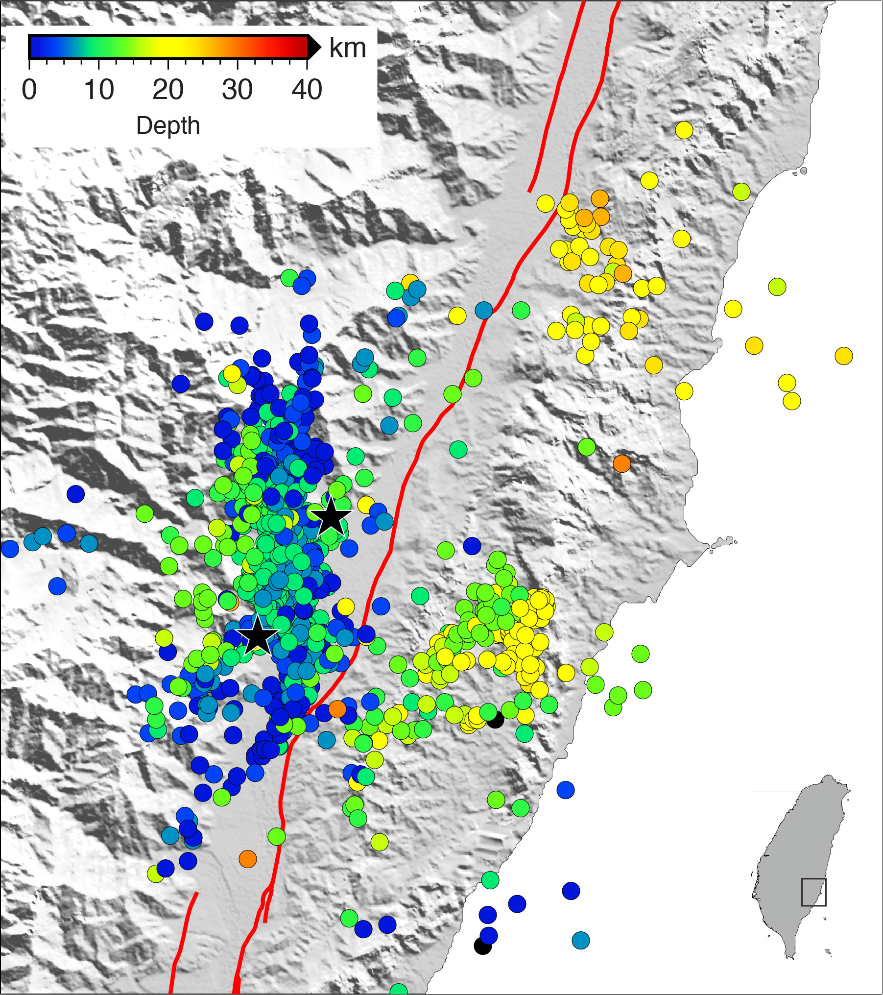

Within two days of the magnitude-6.5 foreshock, a catalog of earthquakes from the event, detected by SeisBlue, was presented to the public. Such a catalog of earthquakes assembled by conventional methods would have taken more than six months to create. The catalog will be used by seismologists and community planners for hazard assessment and disaster relief and by the research community to identify potential locations of surface ruptures.
References
https://github.com/SeisBlue/SeisBlue
Mousavi, S. M., Ellsworth, W. L., Zhu, W., Chuang, L. Y., & Beroza, G. C. (2020). Earthquake transformer—an attentive deep-learning model for simultaneous earthquake detection and phase picking. Nature communications, 11(1), 1-12.