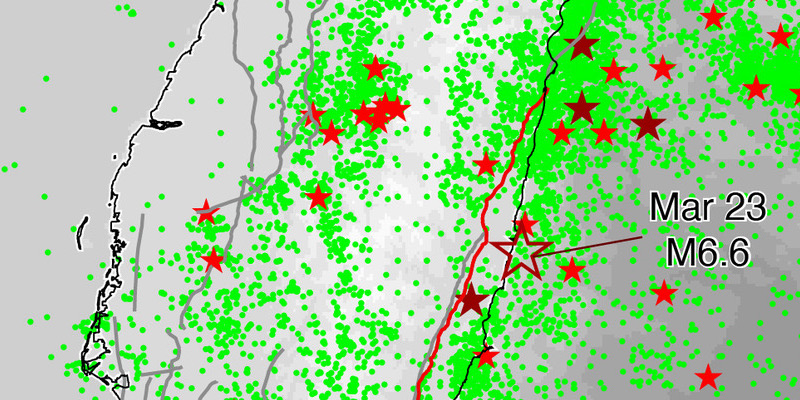
The pattern of recent earthquakes in the area indicated this event was likely, and an even larger quake is possible in the future.
By Wei-An Chen, B.S., Jo-Chen Kao, and Chung-Han Chan, Ph.D., Earthquake Disaster & Risk Evaluation and Management Center (E-DREaM)
Citation: Chen, W., Kao J., Chan C., 2022, Magnitude-6.6 earthquake warns east-central Taiwan of shaking potential, Temblor, http://doi.org/10.32858/temblor.248
This article is also available in Traditional Chinese.
A magnitude-6.6 earthquake struck off Taiwan’s central Pacific coast, 15 kilometers (9 miles) east of Changbin at 1:41 am on Wednesday (March 23). Ground shaking reached intensities of up to 5+ to 6- in southern Hualien and northern Taitung counties, respectively.
The Public Warning System in Taiwan automatically issued an earthquake early warning to cell phones in areas, where shaking was expected to be strong (intensity higher than 3 in Taipei and higher than 4 elsewhere). Several strong aftershocks up to magnitude-6.1, followed the magnitiude-6.6 mainshock, likely keeping some people up all night.
Wednesday’s earthquake — named after the nearby township of Yuli — struck in a seismically active area, so the event is not unexpected. The mainshock occurred near the central Huadong Valley, and could be associated with the Longitudinal Valley Fault System, which is the boundary between the Eurasian and Philippine Sea Plates. A great number of earthquakes have taken place in the vicinity, including a series of magnitude-7.0 and larger events in 1951, which is attributed to rupture along the Longitudinal Valley Fault System.
In 2020 a team of geologists, seismologists and historians evaluated available earthquake data, historical records and studies of active faults in the country and created the Taiwan Earthquake Model (TEM). Seismically active areas generally remain active and the TEM includes an earthquake forecasting map, representing a plausible seismicity rate in the future. In the northern and southern regions of the Longitudinal Valley, a magnitude-6 or greater earthquake is expected every 10 and 16 years, respectively.
The rupture probability of a fault can be quantified based on a time-dependent rupture model, which assumes that earthquake probability is expected to increase as more time elapses since the previous earthquake. The last magnitude-7.0 or greater earthquake on the Longitudinal Valley Fault happened 71 years ago, in 1951. The rupture recurrence interval for that fault — obtained from paleo-seismic records — is 189 years. The model suggests its rupture probability in the coming 50 years is 22%.
Finding precursor phenomenon is an alternative way to assess the possibility of a large earthquake striking in the future. Earthquake frequency depends, in part, on magnitude; smaller earthquakes strike more often than larger ones. The relative number of small and large earthquakes follows a predictable relationship and by calculating the ratio between the two — the b-value — we can determine the likelihood of a large earthquake in the future. A low b-value for a region over a given period means more moderate events (magnitude 3-5) struck than smaller ones and implies a fault could be accumulating stress for the next large earthquake.
We evaluated b-values over the last year up to just prior to Wednesday’s Yuli earthquake. Compared to the overall average of 0.88 in Taiwan, the significantly low b-value of 0.55 near the Yuli epicenter suggests a strong precursory signal prior to the event. In addition, this signal became more significant with time. We evaluated earthquake activity within 30 kilometers (20 miles) of the epicenter for different years and found a decreasing trend of b-values with time, suggesting that stress was accumulating prior to the Yuli earthquake. This case highlights how monitoring b-value evolution could help seismologists track stress in the crust.
Unfortunately, the occurrence of the Yuli earthquake doesn’t mean the potential for future larger earthquakes has decreased. The magnitude of this event did not reach the presumed maximum magnitude for earthquakes on the Longitudinal Valley Fault — magnitude-7.5 — suggesting that the stress on the fault system has not been totally released. Additionally, the Longitudinal Valley Fault could alternatively rupture in a segmented way, as was the case of the 1951 earthquake sequence. As a result, the probability of a magnitude-7.0 to 7.5 rupture is 28% within 50 years. Moreover, other faults in the vicinity, including the Milun fault to the North and the Central Range structure, Luyeh fault and Taimali Coastline structure to the South are active. Their summed rupture potential is 95%, 59% and 37% in 50 years for magnitudes 6.5, 6.7 and 7.0 respectively, indicating high hazard potential in eastern Taiwan.
As a plate boundary, the Longitudinal Valley Fault is one of the major threats to Taiwan. An event could result in severe ground shaking along the eastern coast and even in metropolitan areas in western Taiwan. Thus, it is of the utmost importance to build up a seismic-resilience society before the next big one.
References
Chen, W. S., Yen, I. C., Fengler, K. P., Rubin, C. M., Yang, C. C., Yang, H. C., … & Lin, Y. H. (2007). Late Holocene paleoearthquake activity in the middle part of the Longitudinal Valley fault, eastern Taiwan. Earth and Planetary Science Letters, 264(3-4), 420-437.

