

A pair of 2025 magnitude 6.1 earthquakes on the Sındırgı segment of Western Türkiye’s strike-slip Simav fault zone appear to have ruptured new normal faults.
By Haluk Eyidoğan, Emeritus Professor, İstanbul Technical University, Department of Geophysics, Sarıyer, İstanbul, Türkiye
Citation: Eyidoğan, H., 2026, Is a doublet signaling the formation of a new basin in Sındırgı, Western Türkiye?, Temblor, http://doi.org/10.32858/temblor.380
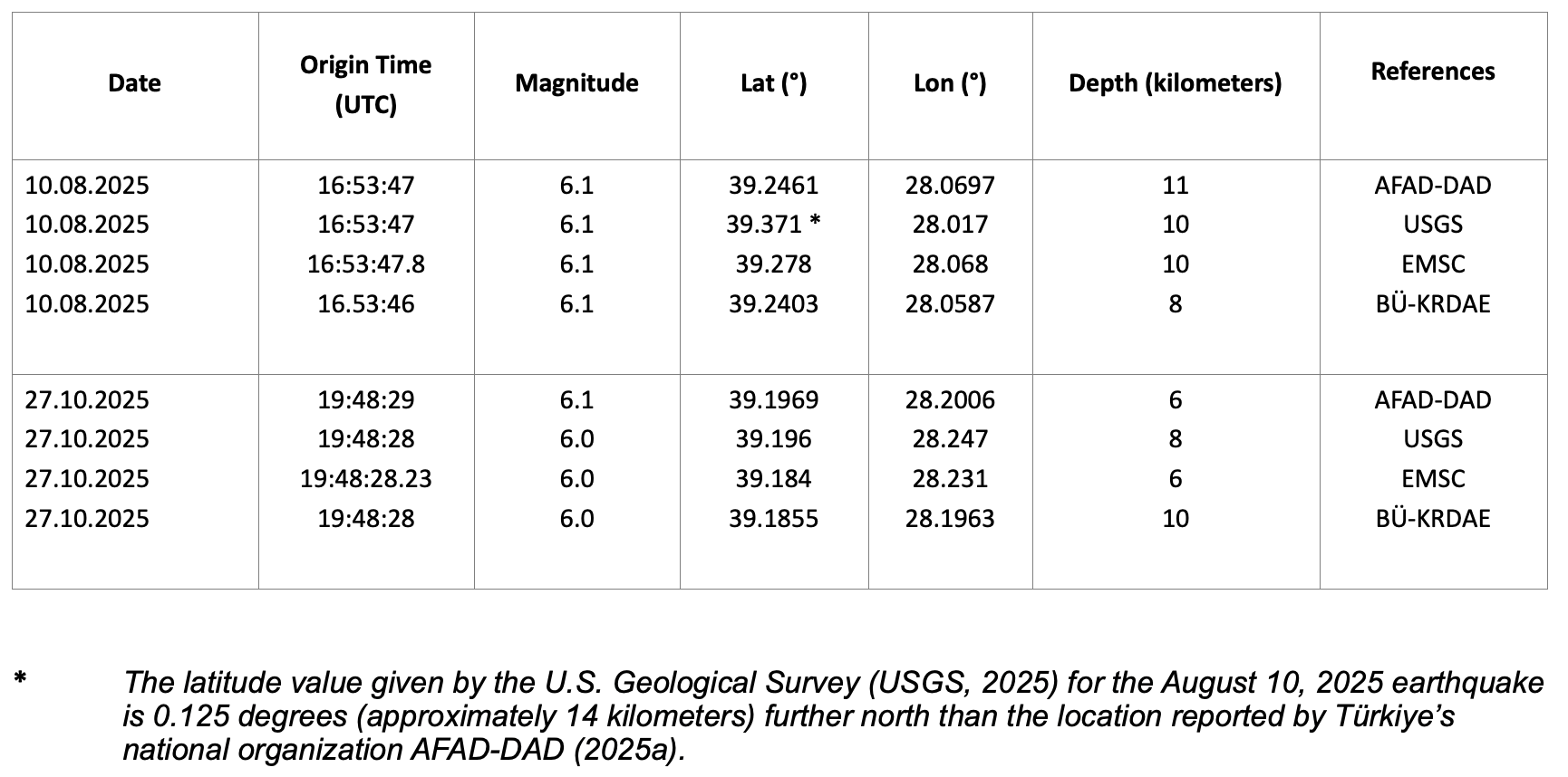
On August 10, 2025, a magnitude 6.1 earthquake occurred 11 kilometers south of the Sındırgı district of Balıkesir Province in western Türkiye at a depth of 11 kilometers (Table 1). In the villages of the Sındırgı district, a total of 1,036 residences were severely damaged or destroyed. According to AFAD-DAD (2025a) report, one person perished.
On October 27, 2025, a second earthquake of magnitude 6.1 occurred, 78 days after the first and 15 kilometers to the southeast. The second shock ruptured at a depth of 6 kilometers (Table 1), and damaged 607 residences and 93 workplaces (Hürriyet, 2025; ÇŞİB, 2025).
These two earthquakes present an interesting example of a doublet — two similarly-sized mainshocks that occur near one another both spatially and temporally. Doublet earthquakes can occur as a result of movement along the same fault, on conjugate faults, or on different sections of neighboring faults.
In this article, I explore the fault responsible for this doublet; the seismicity that preceded and succeeded the mainshocks; the significance of the change in location of the earthquake sequence over time; and the style of faulting. In particular, I use this information to argue for the development of a new basin controlled by normal faulting.
The Simav fault zone
The major fault associated with these events is the Sındırgı Fault, which is the westernmost branch of the Simav fault zone (Figure 1). According to the AFAD-DAD (2025b) earthquake catalog, the only major earthquake that may have been associated with the Sındırgı Fault between January 1, 1900 and August 9, 2025 occurred on October 28, 1942. The event had a surface wave magnitude of 5.4., and ruptured just north of the Sındırgı Fault (Figure 1).
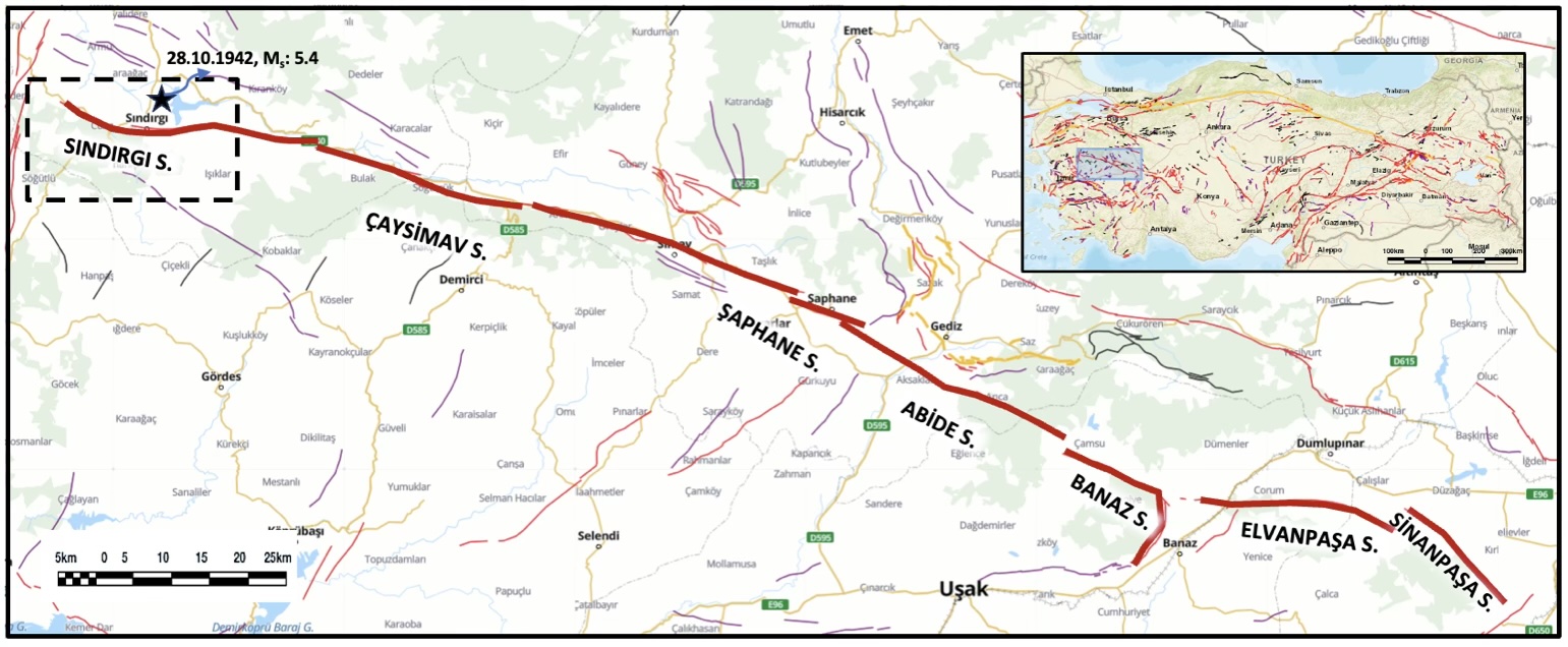
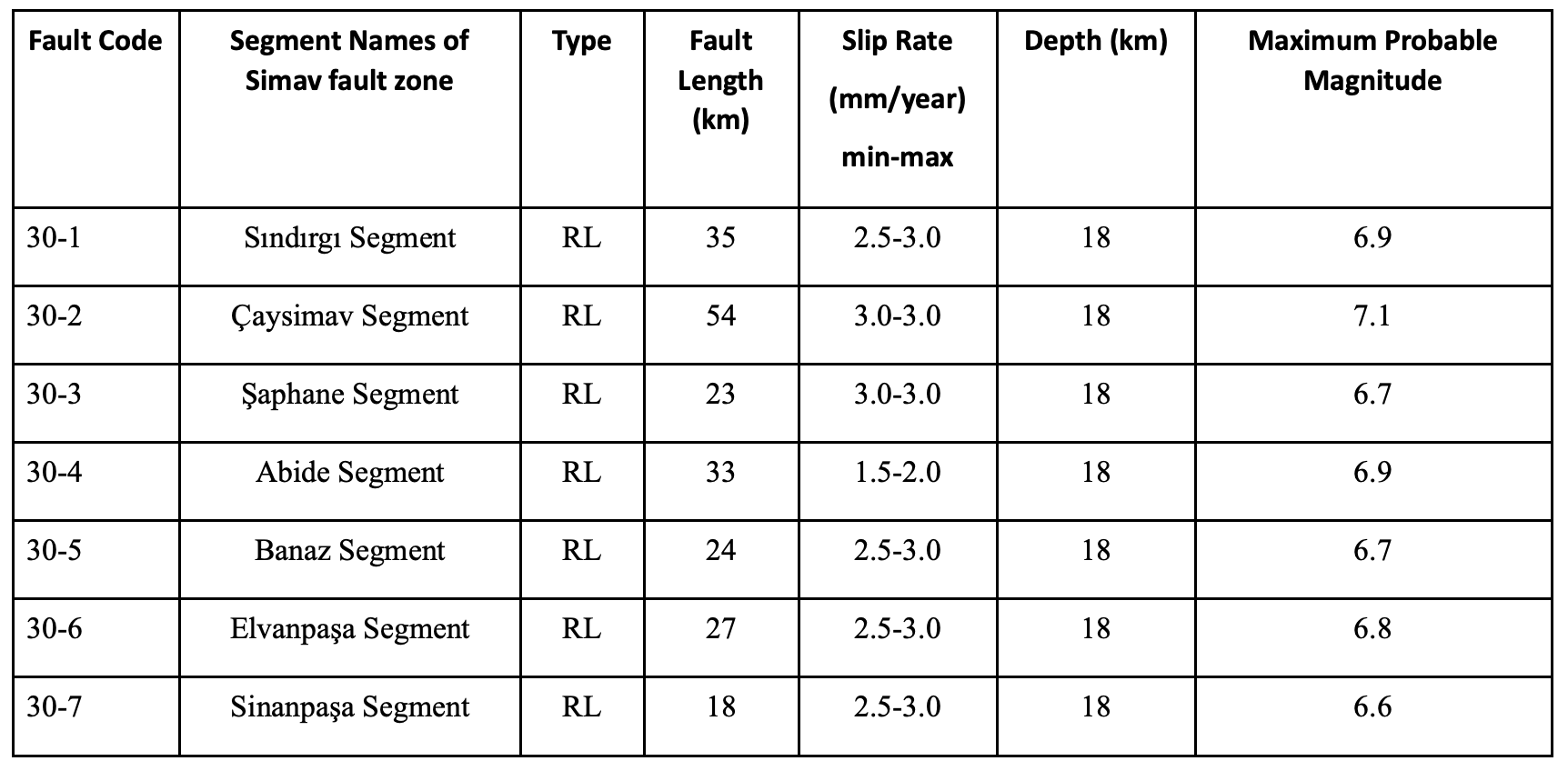
The right-lateral strike-slip Simav fault zone is 205 kilometers long (Emre et al., 2018; MTA, 2025) and is classified as an active fault with significant earthquake potential. The Simav fault zone comprises seven active fault segments with right-lateral strike-slip movement. From west to east, they are: Sındırgı, Çaysimav, Şaphane, Abide, Banaz, Elvanpaşa and Sinanpaşa (Figure 1 and Table 2). According to Emre et al. (2018), basins located along the length of the fault formed as a result of releasing bends caused by changes in the orientation of the fault. In such a scenario, the continued overall right-lateral motion of the fault zone results in normal motion at these bends.
The Simav fault zone has attracted the attention of many Earth scientists and has been studied using geological, geophysical and seismological methods (Arpat and Bingöl, 1969; Seyitoğlu, et al., 1992; Doğan and Emre, 2006; Toker, 2014; Kartal and Kadirioğlu, 2015; Toker et al., 2018). It was initially defined as a normal fault by Seyitoğlu (1997). More recently, Gündoğdu et al. (2020) suggested that the Simav fault zone behaved as a strike-slip fault in the Early Miocene, but today acts as a normal fault. What can the doublet and its aftershocks tell us about this apparent discrepancy regarding the sense of motion of this major fault zone?
Spatial and temporal variation of seismicity
This research uses the AFAD-DAD (2025b) database of earthquakes with magnitude 1.0 and greater. For the numerous earthquakes with magnitudes of 4.0 and less, the database reports the local magnitude, or ML. To homogenize all magnitudes to a single scale, local magnitudes are converted to moment magnitude (known as Mw) using the following equations from Goertz‐Allmann et al. (2011):
Mw = 0.594*ML+0.985 (ML<2)
Mw = 1.327+0.253*ML+0.085*ML2 (2≤ML≤4)
Mw = ML-0.3 (ML>4)
Hereafter, all magnitudes are reported as moment magnitude unless otherwise stated.
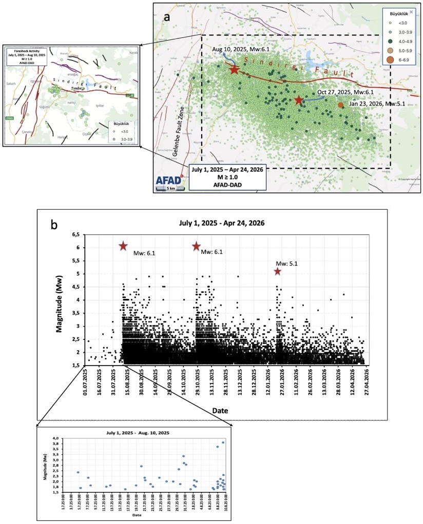
Between July 1, 2025 and April 24, 2026, a total of 23,385 earthquakes with magnitudes 1.0 or greater occurred in the region around the Sındırgı segment (Figure 2a, b). Prior to August 10, 2025, the date of the initial mainshock, a remarkable burst of microseismic activity occurred here. Because of the location and frequency of seismic activity, I consider these events foreshocks.
Migration of Sındırgı seismicity
The most striking feature of the Sındırgı earthquake sequence is the migration of seismicity from west to east in a southeast direction from the western end of the Sındırgı Fault (Figure 3).
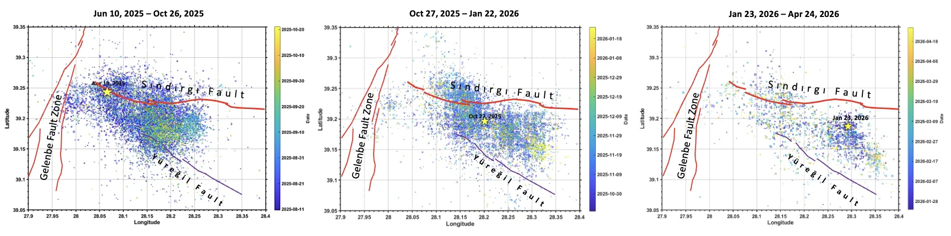
The aftershocks of the first magnitude 6.1 earthquake migrated southeastward (Figure 3a, seismic activity in blue and yellow), extending from the western end of the Sındırgı Fault. The epicenter of the second magnitude 6.1 earthquake, which occurred on October 27, 2025, was located southeast of the previous mainshock, where aftershocks were concentrated (Figure 3b). On January 23, 2026, a large aftershock of magnitude 5.1 occurred east of the October 27 earthquake (Figure 3c).
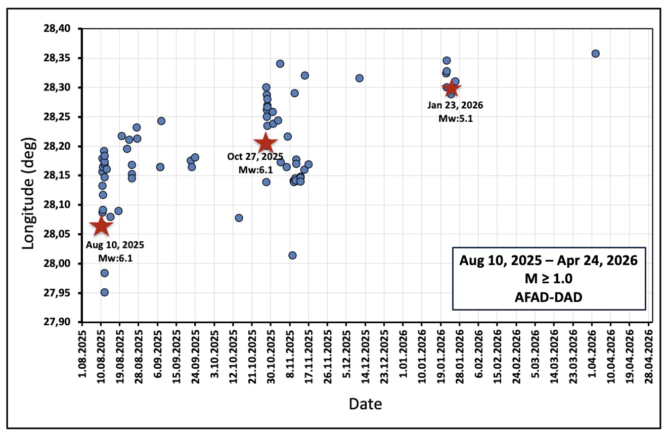
Figure 4 shows the graph of the longitudes of the epicenter of earthquakes with magnitude 4.0 or greater changing over time. In Figure 4, we see the southeastward migration of the doublet earthquakes and their aftershocks.
Focal mechanism solutions of the Sındırgı doublet
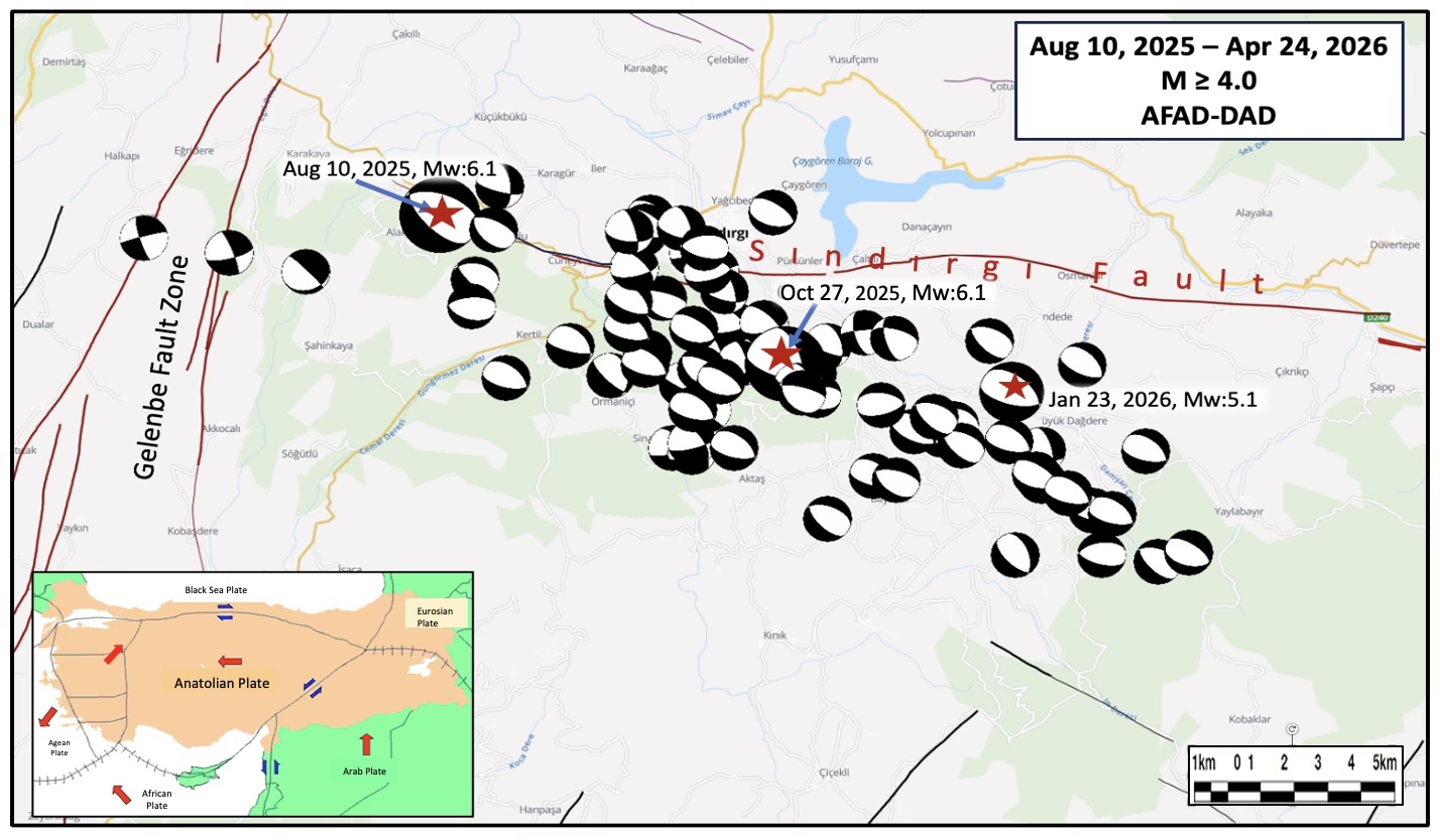
The locations of 75 focal mechanism solutions (AFAD-DAD, 2025c) — those of the three major earthquakes of magnitude 6.1, 6.1 and 5.1, and 72 aftershocks of magnitude 4.0 and above — are plotted on a map in Figure 5. The focal mechanisms (beachball diagrams) indicate that northwest-southeast trending normal faults ruptured progressively southeast of the Sındırgı Fault during the earthquake sequence. Taken together, the focal mechanism solutions and spatial distributions of aftershocks suggest that normal faults are developing in the shallow parts of Earth’s crust south of the Sındırgı Fault.
Because focal mechanism solutions provide two fault planes according to the double-couple rule, it is difficult to determine which plane hosted the normal fault movement without finding a visible fault trace in the field. In other words, do the fault planes dip to the southwest or the northeast?
Additional observations
Several studies have been published recently on the topic of these earthquakes. Their results sometimes conflict.
By integrating field-based geology, seismology and InSAR data, Sözbilir et al. (2026) determined that the initial earthquake and aftershocks were related to newly mapped secondary faults of the Emendere Fault Zone. Coulomb stress transfer modeling in that work showed that the stress from the August 10, 2025 earthquake was transferred southeast, triggering the October 27, 2025 earthquake and potentially loading neighboring faults. The authors suggested that the characteristics of Sındırgı earthquake activity differ from typical dip-slip normal faulting events in Western Anatolia.
Using InSAR and stress inversion methods, Kutoğlu et al. (2026) found that the Sındırgı seismic activity that began on August 10, 2025 does not coincide with a single fault plane, but rather belongs to a tectonic structure composed of previously unmapped fault segments. The authors suggested that the switch from normal faulting during the first mainshock to oblique faulting with strike-slip motion during the second main shock may be related to stress transfer occurring within a complex fault system. The researchers noted that their field investigations in the earthquake zone revealed new surface cracks and fault traces. These observations provide evidence of shallow deformation, but the authors were unable to determine the dip direction.
In other work, Seyitoğlu (2025) argued that the initial mainshock behaved as a low-angle normal (listric) fault, similar to examples found elsewhere in western Anatolia (Eyidoğan and Jackson, 1985), and that this fault extended northward at an angle of 34°. However, using Sentinel-1 InSAR observations and Coulomb stress modeling, Eski and Tepe (2026) determined that a normal fault dipping 41° to the northeast hosted the initial rupture. This finding does not confirm a low-angle listric faulting model. Eski and Tepe (2026) noted that their observations could be explained by a transtensional environment rather than a simple normal fault.
On the other hand, based on the combination of geological, geodetic (GNSS) and seismological data, Tiryakioğlu et al. (2026), stated that the initial mainshock occurred along a northwest-southeast trending normal fault dipping to the southwest — opposite the dip direction reported by Seyitoğlu (2025) and Eski and Tepe (2026).
Outstanding questions
The Simav fault zone classified as a right-lateral strike-slip fault according to Türkiye’s officially published Active Fault Map (MTA, 2025). The oblique normal fault plane solution for the second mainshock, the October 27, 2025 magnitude 6.1 event, indicates a different stress field than the initial mainshock, which had a pure normal fault solution.
The fault plane solutions of 75 aftershocks with a magnitude of 4.0 and above between August 10, 2025, and April 24, 2026, predominantly exhibit normal fault movement. This complex tectonic scenario, described as a “hybrid mechanism” by Sözbilir et al. (2026) necessitates an investigation into whether a northeast-southwest extensional regime is developing in the northwestern region of the strike-slip Simav Fault Zone.
These many normal faults raise the question: Is a new basin being formed and controlled by developing normal faults? If a new basin is developing, what seismotectonic “hybrid mechanism,” or process, determines its formation?
According to the studies conducted after the earthquake, it is clear that the earthquakes occurred on a northwest-southeast trending zone with normal motion, but the direction of fault dip is still debated. Of the studies conducted to date, only Eski and Tepe (2026) indicate that the initial mainshock dipped northeast.
Conclusion
In examining the temporal and spatial distribution of earthquakes near the Sındırgı Fault, starting with the magnitude 6.1 mainshock on August 10, 2025, the magnitude 6.1 mainshock 78 days later, I’ve shown how seismic activity migrated southeastward. Other studies show this same behavior via InSAR (Sözbilir et al, 2026; Kutoğlu et al, 2026; Qiao et al, 2026; Eski and Tepe, 2026).
These earthquakes occurred at the northwestern end of the Simav Fault Zone, officially classified as a right-lateral strike-slip fault. The earthquakes indicate an extensional tectonic regime developing along the characteristic northwest-southeast trend of Western Anatolia. However, the dip direction of the faults that hosted the 2025-2026 events remains debated. Additional geological, seismological, and geodetic investigations would help definitively determine dip direction. Furthermore, additional examination of stress transfer (Das and Scholz, 1981; Stein, 1999; King and Cocco, 2001; Riga and Balocchi, 2018) would contribute to a better understanding of the seismotectonics of the region.
Reviewer: Dr. Yu Jiang, Ph.D.
Science Editor: Dr. Alka Tripathy-Lang, Ph.D.
References
AFAD-DAD, 2025a, 10 Ağustos 2025 Sındırgı (Balıkesir) Mw6.1 depremi raporu, Afet ve Acil Durum Yönetimi Başkanlığı, Deprem Dairesi Başkanlığı, Ankara, 22 p.
AFAD-DAD, 2025b, Afet ve Acil Durum Yönetimi Başkanlığı, Deprem Araştırma Dairesi Başkanlığı, Ankara, https://deprem.afad.gov.tr/event-catalog.
AFAD-DAD, 2025c, Afet ve Acil Durum Yönetimi Başkanlığı, Deprem Araştırma Dairesi Başkanlığı, Ankara, https://deprem.afad.gov.tr/event-focal-mechanism.
BÜ-KRDAE, 2025, Boğaziçi Üniversitesi, Kandilli Rasathanesi ve Deprem Araştırma Enstitüsü, http://www.koeri.boun.edu.tr/sismo/2/tr/.
ÇŞİDB, 2025, Çevre, Şehircilik ve İklim Değişikliği Bakanlığı, Türkiye, https://www.csb.gov.tr/sindirgi-da-hasar-tespit-calismalari-tamamlandi-bakanlik-faaliyetleri-42895.
Das, S. and Scholz, C. H., 1981, Theory of time-dependent rupture in the Earth, Journal of Geophysical Research, 86, 6039–6051.
Doğan, A. and Emre, Ö., 2006, Ege graben sisteminin kuzey sınırı: Sındırgı-Sincanlı Fay Zonu, 59. Türkiye Jeoloji Kurultayı, Ankara, Türkiye, Bildiriler Kitabı, 20–24 March 2006, 83–84.
Emre, Ö., Duman, T. Y., Özalp, S., Saroğlu, F., Olgun, S., Elmacı, H., and Can, T., 2018, Active fault database of Turkey, Bulletin of Earthquake Engineering, 16, 3229–3275.
EMSC, 2025, Euro-Mediterranean Seismological Centre, https://www.emsc-csem.org.
Eski, S. and Tepe, Ç., 2026, Interacting normal and strike-slip fault systems in Western Anatolia: InSAR-constrained rupture and aftershock migration of the 2025 Sındırgı earthquake, Türkiye, Journal of Asian Earth Sciences, 107171, https://doi.org/10.1016/j.jseaes.2026.107171.
Eyidoğan, H. and Jackson, J., 1985, A seismological study of normal faulting in the Demirci, Alaşehir and Gediz earthquakes of 1969–70 in western Turkey: implications for the nature and geometry of deformation in the continental crust, Geophysical Journal of the Royal Astronomical Society, 81, 569–607.
Goertz-Allmann, B. P., Goertz, A. and Wiemer, S., 2011, Stress-drop variations of induced earthquakes at the Basel geothermal site, Geophysical Research Letters, 38(9), L09308, 1–5.
Gündoğdu, E., Özden, S. and Tolga, T., 2020, Kinematic and seismotectonic properties of Sındırgı Fault and Düvertepe Fault Zone surroundings: West Anatolia (Türkiye), Çanakkale Onsekiz Mart University, Journal of Advanced Research in Natural and Applied Sciences, 6(2), 378–395, https://doi.org/10.28979/jarnas.844958.
Hürriyet Gazetesi, 2025, https://bigpara.hurriyet.com.tr/haberler/genel-haberler/bakan-kurum-balikesirde-729-binadaki-1036-bagimsiz-bolum-agir-hasarli-veya-yikik_ID1616579/.
King, G. C. P. and Cocco, M., 2001, Fault interaction by elastic stress changes: New clues from earthquake sequences, in Advances in Geophysics, 44, 1–VIII.
Kutoğlu, Ş. H., Softa, M., Akgün, E., Nas, M. and Topal, S., 2026, Analyzing fault reactivation behavior using InSAR, stress inversion, and field observations during the 2025 Sındırgı earthquake sequence, Simav Fault Zone, Western Türkiye, Sensors, 26, 760, https://doi.org/10.3390/s26030760.
MATLAB, 2025, MATLAB-R2024b, https://ch.mathworks.com/products/new_products/release2024b.html.
MTA, 2025, T.C. Maden Tetkik ve Arama Genel Müdürlüğü, Türkiye Aktif Fay Haritası, https://www.mta.gov.tr/v3.0/hizmetler/yenilenmis-diri-fay-haritalari.
Perinçek, D., 2025, Sındırgı depremleri magma sokulumu ile ilgili olabilir mi? Kuzeydoğu güneybatı doğrultulu fayların Sındırgı depremlerindeki rolü, https://www.researchgate.net/publication/395939567.
Qiao, X., Gao, H. Z., Zhao, D. Z. and Yan, S. Y., 2026, Coseismic deformation and fault slip distribution of the 2025 Mw6.2 Sındırgı earthquake (western Turkey) revealed by InSAR, Chinese Journal of Geophysics (in Chinese), http://en.dzkx.org/article/doi/10.6038/cjg2026T0655.
Riga, G. and Balocchi, P., 2018, Double earthquakes classification and seismic precursors, Open Journal of Earthquake Research, 7, 1–27, https://doi.org/10.4236/ojer.2018.71001.
Seyitoğlu, G., 1997, The Simav Graben: An example of young E-W trending structures in the Late Cenozoic extensional system of western Turkey, Turkish Journal of Earth Sciences, 6, 135–141.
Seyitoğlu, G., 2025, Sındırgı ve Simav depremleri ışığında Simav Fay Zonu: 2025.10.27 (Mw 6.1) Sındırgı depreminin tektonik anlamı, Preprint, ResearchGate, https://doi.org/10.13140/RG.2.2.19448.30728.
Seyitoğlu, G., Scott, B. C. and Rundle, C. C., 1992, Timing of Cenozoic extensional tectonics in west Turkey, Journal of the Geological Society, 149(4), 533–538, https://doi.org/10.1144/gsjgs.149.4.0533.
Sözbilir, H., Eytemiz, C., Bayık, Ç., Arca, D., Utku, M., Füzün, S. Ö., Bakak, Ö., Özdağ, Ö. C., Aksaz, M., Tatar, O., Türkoğlu, M., Kılıçarslan, Ö. and Kaplan, M., 2026, Seismic source analysis of the 10 August 2025 6.1 Sındırgı and the 27 October 2025 6.1 Sındırgı earthquakes (Western Anatolia Extensional Province, Türkiye) based on geological, seismological, and InSAR data, Seismological Research Letters, https://doi.org/10.1785/0220250346.
Stein, R. S., 1999, The role of stress transfer in earthquake occurrence, Nature, 402, 605–609.
Tiryakioğlu, İ., Gezgin, C., Aktuğ, B. et al., 2026, Revealing the source mechanism of the August 10, 2025 Sındırgı Earthquake (Mw 6.3) with geological and geodetic evidence, Advances in Space Research, https://doi.org/10.1016/j.asr.2026.04.047.
Toker, C. E., Ulugergerli, E. U. and Kılıç, A. R., 2018, The Naşa intrusion (Western Anatolia) and its tectonic implication: A joint analysis of gravity and earthquake catalog data, Bulletin of the Mineral Research and Exploration, 156, 247–258.
USGS, 2025, United States Geological Survey, https://earthquake.usgs.gov/earthquakes/search/.
Wiemer, S., 2001, A software package to analyze seismicity: ZMAP, Seismological Research Letters, 72(3), 373–382.
Copyright
Text © 2026 Temblor. CC BY-NC-ND 4.0
We publish our work — articles and maps made by Temblor — under a Creative Commons Attribution-NonCommercial-NoDerivatives 4.0 International (CC BY-NC-ND 4.0) license.
For more information, please see our Republishing Guidelines or reach out to news@temblor.net with any questions.