By Lester Lubetkin

One recent night we were quietly reading in our living room in Hope Alaska, when I heard some low, groaning sounds. I thought it must be the wind. But then we felt gentle, rapid shaking and then a sharp jolt – I looked at my wife and we both recognized it as an earthquake. Would it keep going and get more violent, or was this the end? We both sat there without moving, unsure of what to expect. In our case, there was only a short period of gentle motion, although we heard the standing lamps and hanging fixtures continue to rattle and groan for several seconds. However, we were both hit with the realization that another, stronger earthquake could come at any moment. Or should we expect a tsunami. What should our response be?
Realizing it was an earthquake, and that the power was still on, we immediately went to some web sites to try to learn where the earthquake was, how large it was, and try to understand what our risk was in the immediate future. We went to Temblor, the University of Alaska at Fairbanks Earthquake website, and the USGS Earthquake website. What did we find? A number of small earthquakes, including a 1.7 magnitude earthquake near Chignik, AK, another earthquake near Nikiski, and one not too far from Talkeetna. But surely what we felt was greater than magnitude 1.7!
Hope, Alaska sits in southcentral Alaska, about 20 miles southeast of Anchorage, on the Turnagain Arm of the Cook Inlet, and at the northern end of the Kenai Peninsula. The mountains around Hope and the Turnagain Arm rocket up 2,500 to 3,500 feet with steep flanks and rugged peaks. The evidence of recent uplift, with the landscape being sculpted by ice and glaciers is clearly obvious. In fact, the Turnagain Arm is a fjord that has been filling in with silt from the glaciers still filling some of the valleys surrounding this embayment. The town of Hope, along with Anchorage and the other communities along the Turnagain Arm were heavily damaged by the 1964 Alaska earthquake (magnitude 9.2), during which the land sank 6 to 9 feet.

75 percent of all of the earthquakes of magnitude 5 or greater that occur in the United States happen in Alaska (yes, Alaska is a part of the United States). In fact, across the United States, 4 out of 5 magnitude 2 or greater earthquakes happen in Alaska. Alaska sits just north of a long arcuate subduction zone, where the Pacific Plate is moving northwestward and going under Alaska. This is part of the “ring of fire” surrounding the Pacific Ocean, where earthquakes and volcanoes are concentrated along tectonic plate boundaries. Subduction zones are the source of nearly all of the great earthquakes that occur, and this is no exception in Alaska. The tectonic forces in Alaska are not just limited to the area along the subduction zone, but rather extend well into the State all the way to the Arctic Ocean. But the subduction zone that follows along the southern coast of Alaska and all along the Aleutian Island chain is the biggest generator of seismic activity. And since Hope sits just above this subducting plate, we knew that one earthquake could lead to another!
The University of Alaska at Fairbanks (UAF) has a very active earthquake center with lots of good information and is a great place to look for current earthquake information. When I went to the UAF Earthquake Center website right after the shaking, I didn’t see any earthquakes listed that seemed to match what we felt. So I went to the USGS website and still didn’t see any earthquakes listed of significant size and in the general vicinity.
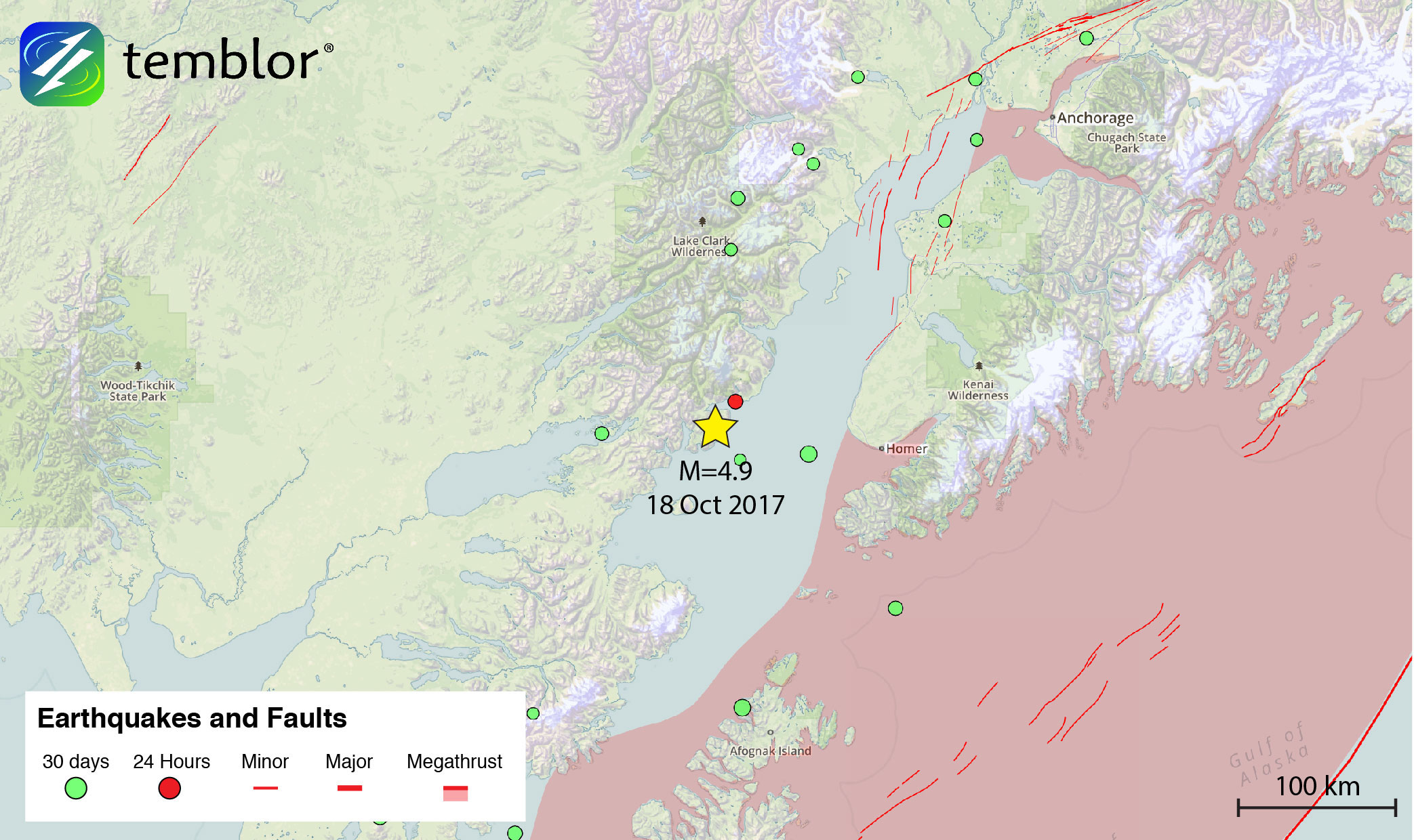
Finally, the earthquake we felt started to show up on the websites. The earthquake was initially reported as a magnitude 4.8 but was later changed to 4.9. It occurred on the west side of the Cook Inlet, about 20 miles from Iliamna Volcano and about 150 miles southwest of Hope. This volcano is part of the active island arc volcanic chain that includes the Aleutian Island chain and lies to the north of the subduction zone. This location suggests the earthquake resulted from motion of the subducting plate. The epicenter was 62 miles deep, also consistent with an earthquake resulting from sliding of a subducting oceanic plate beneath a continental plate. The motion tensor (beach ball) diagram seemed also to fit an earthquake occurring along a subduction zone.
Since that night, we have not felt any more earthquakes, but in looking at the USGS, UAF and Temblor websites, we see that there have been many smaller earthquakes still occurring in this part of the world. So, we way to see when (not if) the big one hits.
-
ډیری عوامل افغاني ټولنې د زلزلې پر وړاندې زیانمنوي
- August 11, 2022 - What’s happening this week in Humboldt County, California: The squeeze - February 6, 2019
- Finding of the unexpected tsunami due to the strike-slip fault at central Sulawesi, Indonesia on 28 September 2018, from the preliminary field survey at Palu - October 15, 2018